
22Jun
Aeromapper Talon successfully completes BVLOS mission over 30Km away
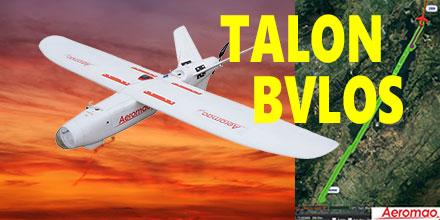 Recently, Aeromao's Aeromapper Talon successfully completed an autonomous mission to a target located 30km away.
The Talon maintained strong communications and its control link throughout the entire mission.
This mission successfully demonstrated the potential for Beyond Visual Line of Sight (BVLOS) operations for the Talon.
The Aeromapper Talon costs only a fraction compared to systems with similar capabilities.
Recently, Aeromao's Aeromapper Talon successfully completed an autonomous mission to a target located 30km away.
The Talon maintained strong communications and its control link throughout the entire mission.
This mission successfully demonstrated the potential for Beyond Visual Line of Sight (BVLOS) operations for the Talon.
The Aeromapper Talon costs only a fraction compared to systems with similar capabilities.
Aeromapper Talon Demonstrates BVLOS
The Aeromapper team carried out the mission in the Andes Mountains of South America. The location of the flight was situated at 2,800m above sea level. The flight had a cruise altitude of 250m agl. Fifty percent of the flight traversed a body of water. The Talon traveled a total distance of 60km in its one hour flight. With a flight endurance of 2-hours, the Talon had enough flight time left to travel an additional 30km. However, the operators decided to bring the UAV back due to peaks in excess of 3,500 m above sea level in the flight path. Currently, the team is planning a future mission to demonstrate 50km reach capabilities. Aeromao's Aeromapper 300 also uses the same long range communication system as the Talon. The demand for BVLOS missions continues to grow throughout the industry. Applications for such missions include: power line and pipeline monitoring, roadways survey, surveillance and wildlife control, as well as long linear missions.Powerful solution for linear mission challenges
"We receive many requests from clients who need to fly linear missions sometimes to survey thousands of kilometers of pipelines, power lines or roadways," said Mauricio Ortiz of Aeromao. "We ourselves have completed hundreds of kilometers of linear projects, and know very well the challenges of these types of operations." The Aeromapper Talon is proving a solid solution given the specific capabilities demanded for these applications. Aeromapper Talon performs well in all:- Ability to operate in difficult terrain and with a mobile GCS with reliable and strong communications.
- Quick deployment and easy operation: the Aeromapper Talon is flight ready in 15 minutes. It is one of the easiest UAVs to operate.
- Several cycles of takeoff and landings per day from different locations: here the hand-launch and parachute landing are pretty much a MUST have. A large area survey needs the flexibility of operating from virtually anywhere.
- Reliable and easy to repair in the field, as well as affordable with interchangeable spare parts.
Complete UAV solution, multiple fronts
Additionally, the Aeromapper Talon is also a multi-mission payload complete solution. It is a great choice for various applications, such as agriculture, centimeter accurate surveys, surveillance, and monitoring. Payloads available include:- 24 Mp RGB + with Parrot Sequoia simultaneously: complete full surveys at high resolution and get vegetation data in a single flight.
- 24 Mp RG + Thermal Infrared: Ideal for pipeline or wildlife monitoring.
- Forward looking day / night payload: An affordable surveillance and observation platform with long range video streaming. All systems are easily swappable.
- Micasense RedEdge: A swappable payload option with serious agriculture power.
- GNSS PPK: Eliminates GCPs and achieves up to 3 cm of accuracy for engineering projects. Also available as a swappable payload.
- Pix4DMapper Aeromao Edition: serious post processing power with the most exhaustive power available. In an affordable bundle package with the complete UAV system.
- Agisfot Photoscan Pro: Affordable and flexible post processing software to become a post-processing Ninja.
 Pollinating Drones: Could Miniature UAVs save the World from Falling Bee Numbers? A number of scientists and drone developers are considering just that scenario.
For several years, scientist around the world have sounded the alarm over falling bee population numbers. Given their importance in the pollination of plants and crops, this is a cause for concern.
Scientists speculate that factors such as human activity and climate change have contributed to the steady decrease in pollinators.
But now researchers are proposing a radical new concept to tackle the troubling issue; tiny miniature drones as pollinators. Most of the world’s food supply comes from plants that require pollination. So, artificial pollinators may turn out to be an innovative and very important solution to securing it.
Pollinating Drones: Could Miniature UAVs save the World from Falling Bee Numbers? A number of scientists and drone developers are considering just that scenario.
For several years, scientist around the world have sounded the alarm over falling bee population numbers. Given their importance in the pollination of plants and crops, this is a cause for concern.
Scientists speculate that factors such as human activity and climate change have contributed to the steady decrease in pollinators.
But now researchers are proposing a radical new concept to tackle the troubling issue; tiny miniature drones as pollinators. Most of the world’s food supply comes from plants that require pollination. So, artificial pollinators may turn out to be an innovative and very important solution to securing it.
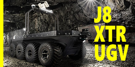 ARGO’s Space, Robotics and Defense Division recently announced the release of the ARGO J8 Atlas XTR (Xtreme Terrain Robot).
This UGV (Unmanned Ground Vehicle) is designed for defense, disaster relief missions and rescue operations.
Today, UGVs are playing an increasingly important role in hazardous and extreme environment operations.
ARGO developed the electric 8-wheeled amphibious, all-terrain mobile robot to help protect the lives of soldiers and keep humans out of harm’s way.
ARGO’s Space, Robotics and Defense Division recently announced the release of the ARGO J8 Atlas XTR (Xtreme Terrain Robot).
This UGV (Unmanned Ground Vehicle) is designed for defense, disaster relief missions and rescue operations.
Today, UGVs are playing an increasingly important role in hazardous and extreme environment operations.
ARGO developed the electric 8-wheeled amphibious, all-terrain mobile robot to help protect the lives of soldiers and keep humans out of harm’s way.
 Affordable, high-end drones coupled with easy-to-use mission-planning tools, created the perfect environment for drones to flourish.
No longer the preserve of specialists, applications using drones have ventured into survey, inspection and volume analysis.
The impact of drones is little short of revolutionary.
But, in the air, the stakes are higher. When things go wrong, the consequences are invariably much more serious than for a ground-based application. One of the biggest threats to drone safety is GNSS interference.
At the very least, disruptions to satellite signals can degrade position quality. When this occurs it causes fall-backs from high-precision RTK and PPP modes to less-precise modes. In the most extreme cases, interference can result in complete loss of signal tracking and positioning.
Affordable, high-end drones coupled with easy-to-use mission-planning tools, created the perfect environment for drones to flourish.
No longer the preserve of specialists, applications using drones have ventured into survey, inspection and volume analysis.
The impact of drones is little short of revolutionary.
But, in the air, the stakes are higher. When things go wrong, the consequences are invariably much more serious than for a ground-based application. One of the biggest threats to drone safety is GNSS interference.
At the very least, disruptions to satellite signals can degrade position quality. When this occurs it causes fall-backs from high-precision RTK and PPP modes to less-precise modes. In the most extreme cases, interference can result in complete loss of signal tracking and positioning.
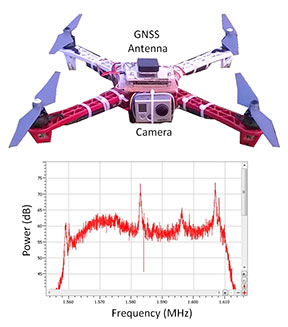 Figure 1 shows what happened to the GPS L1-band spectrum when a GoPro camera was installed on a quadcopter close to the GNSS antenna without sufficient shielding. The three peaks are exactly 24 MHz apart. This points to their being harmonics of a 24 MHz signal: the typical frequency for a MMC/SD logging interface.
An AsteRx4 receiver, which includes the AIM+ system, was selected for this setup. As well as mitigating the effects of interference, AIM+ includes a spectrum plot to view the RF input from the antenna in both time and frequency domains.
At the installation stage, the ability to view the RF spectrum is an invaluable tool for identifying the source of interference. Plus, it helps with determining the effectiveness of measures such as modifying the setup or adding shielding.
For the quadcopter installation in this example, the loss of RTK was readily diagnosed. The problem was solved by placing the camera in a shielded case. All this while the quadcopter was still in the workshop.
Figure 1 shows what happened to the GPS L1-band spectrum when a GoPro camera was installed on a quadcopter close to the GNSS antenna without sufficient shielding. The three peaks are exactly 24 MHz apart. This points to their being harmonics of a 24 MHz signal: the typical frequency for a MMC/SD logging interface.
An AsteRx4 receiver, which includes the AIM+ system, was selected for this setup. As well as mitigating the effects of interference, AIM+ includes a spectrum plot to view the RF input from the antenna in both time and frequency domains.
At the installation stage, the ability to view the RF spectrum is an invaluable tool for identifying the source of interference. Plus, it helps with determining the effectiveness of measures such as modifying the setup or adding shielding.
For the quadcopter installation in this example, the loss of RTK was readily diagnosed. The problem was solved by placing the camera in a shielded case. All this while the quadcopter was still in the workshop.
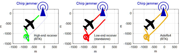 Figure 2 shows how a 10mW chirp jammer can knock out RTK positioning over more than 1 km in a high-end receiver.
Even a low-end consumer-grade L1 receiver, being less accurate and thus less sensitive, loses stand-alone positioning over several hundred meters.
With AIM+ activated, the AsteRx4 is able to maintain an RTK fix throughout the simulated flight. It also shows no degradation to its position variance.
Figure 2 shows how a 10mW chirp jammer can knock out RTK positioning over more than 1 km in a high-end receiver.
Even a low-end consumer-grade L1 receiver, being less accurate and thus less sensitive, loses stand-alone positioning over several hundred meters.
With AIM+ activated, the AsteRx4 is able to maintain an RTK fix throughout the simulated flight. It also shows no degradation to its position variance.
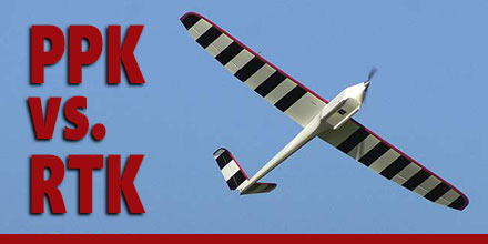 UAS vendors targeting markets from commercial survey to agriculture are fielding systems with real-time kinematic GNSS (RTK) capability.
In principle, RTK promises accuracies at the 1-3cm level. The main purpose is to minimize or eliminate the need for ground control points, thereby reducing cost.
Altavian uses GNSS receivers upgradeable to RTK operation, but favors another approach for this level of accuracy: post-processed kinematic (PPK). There are a couple of reasons why:
UAS vendors targeting markets from commercial survey to agriculture are fielding systems with real-time kinematic GNSS (RTK) capability.
In principle, RTK promises accuracies at the 1-3cm level. The main purpose is to minimize or eliminate the need for ground control points, thereby reducing cost.
Altavian uses GNSS receivers upgradeable to RTK operation, but favors another approach for this level of accuracy: post-processed kinematic (PPK). There are a couple of reasons why:
 Hemisphere GNSS recently announced the