UAS vendors targeting markets from commercial survey to agriculture are fielding systems with real-time kinematic GNSS (RTK) capability.
In principle, RTK promises accuracies at the 1-3cm level. The main purpose is to minimize or eliminate the need for ground control points, thereby reducing cost.
Altavian uses GNSS receivers upgradeable to RTK operation, but favors another approach for this level of accuracy: post-processed kinematic (PPK). There are a couple of reasons why:
RTK requires a GNSS base station equipped with a transmitter with a reliable link to a fairly dynamic moving platform.
The rover (on the UAS) itself requires a dedicated receiver for the corrections.
These primary reasons carry some further implications for the cost of deployment, especially when considered against PPK.
PPK vs.RTK
RTK operations not only require a stationary base station, but it must be located at a known control point. Provided the base station is deployed for long enough periods of time, this is not too much of a problem.
The base station’s precise location can be determined post-mission if no control points are already present. In this case, a global shift of the aircraft’s trajectory must be done once the position of the base station is determined, taking away some of the benefits of a ‘real-time’ solution.
PPK requires a base station as well. But in many cases, at least in the Eastern US, the public CORS network may be dense enough to provide a base station reasonably close to your project. But, it’s likely you will need a base station of your own. This represents slightly less investment in an over-the-air link to the rover. However, it comes with the possibility of loss-of-lock.
Losing Lock
In both RTK and PPK, when the rover loses lock, a new integer ambiguity resolution procedure must be initiated.
The advantage of PPK is that the search can proceed from previous and future data relative to that instant. Additionally, forward and reverse solutions in PPK are optimally combined and give an estimate of a solution’s consistency.
RTK solutions cannot use data that has not yet been recorded. If you want to eliminate ground control points and you chose an RTK system, there is no external information for basing accuracy estimates.
Finally, it is worth noting that antennas light enough to be mounted on a small UAS are not geodetic-grade and are not likely calibrated for phase-center variation (PCV), let alone the actual location of the phase center. This means that you might get a reported solution accuracy of 2cm, but it could easily be very misleading.
With a PPK solution, at least you can see if the forward and reverse solutions agree within certain bounds (and we acknowledge this is a very limited vote of confidence for any kinematic solution, but it’s better than nothing).
Conclusion
Ultimately, there is no replacement for real ground truth, especially if your data product must be certified to a specific level of accuracy. However, strategies to minimize the requirements on GCPs can vary widely in their effectiveness, depending on your needs.
If positional accuracies of a few decimeters are acceptable, real-time L-band corrections through a subscription service such as TerraStar-D are very attractive alternatives that require no base stations at all.
You can find and shop Altavian's line of solutions at Unmanned Systems Source.
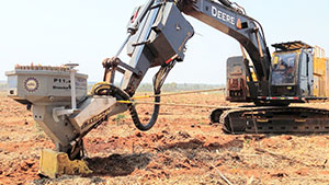
Looking for a GPS receiver for moving earth, mining or construction? Consider the following...
GPS receivers can assist operators in making better decisions by providing precise position information (indicate-only mode). Or the GPS receiver, as part of a guidance system, can take over the operation of the machine’s implement itself (fully-automatic mode) to follow a preloaded design.
In fully-automatic mode, the RTK centimeter-level precision of the GPS guidance system is far more accurate and consistent than relying on the operator’s skill alone.
Trenches are dug to exact depths, tractors are steered in perfect rows, piling rigs know the precise location for planting piles and surfaces are fine graded the first time. Work is completed quicker, more cheaply and to a higher specification when the need to carry out frequent measurements and surveys is not needed.
Compared to a Total Station, a GPS RTK system setup is quick and doesn’t require any of the elements to be in line of sight. A single reference base station can furnish all rover machines on-site continuously with RTK differential corrections. The status of the project and location of every machine on-site is updated in real-time giving site managers a full overview of progress.
GPS Receivers
Machine control applications are among the most challenging for GPS receivers. The physical and radio environments can be difficult enough but operators will always try to push their equipment to its limits. So what GPS receiver capabilities are needed for consideration as a suitable candidate for machine control? There are six prime considerations.
AsteRX4 GPS receiver at work helping plant trees
1) Position precision in difficult conditions
In RTK mode, using a base station that’s not too far away, high-end GPS receivers calculate position with a precision of less than 1 centimeter (0.4 inch). Difficult conditions can degrade the position precision and can even result in wrong position fixes.
Construction sites present their own set of challenges. Large structures and other machines nearby can cause multi-path. Foliage can be particularly problematic for GPS signal quality. And operators can’t always be assured of a clear view of the sky.
Any GPS receiver worth its salt should be adeptly manage the typical conditions on a building site. The consequences of a wrong position fix can be costly and time consuming. A piling operator needs the exact position and orientation of the rig to plant a pile. After all, there are far better ways to spend time than extracting wrongly-placed piles.
2) Low latency and high data output rate
Latency is the time it takes for the receiver to calculate and output a position. Lower latencies and higher position update rates provide more responsive machines that operate at higher speeds without loss of performance.
The highest performing GPS receivers today can output data at upwards of 50 Hz with latencies of less than 20 ms.
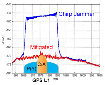
AsteRx-U spectrum analyser in the presence of a chirp jammer both before (blue) and after (red) activation of AIM+
3) Interference mitigation
A delivery vehicle arriving on-site with a chirp jammer can knock out RTK and bring operations to a standstill. The prevalence of such devices, as well as interference from other non-intentional sources continues to increase. Interference mitigation is now an essential tool for a machine control receiver.
Today's highest performing GPS receivers can mitigate against simple continuous narrow-band and pulsed interferers as well as more complex wide-band transmitters such as chirp jammers and other PPDs (Personal Privacy Devices).
4) Heading
Machines such as excavators have a platform that rotates independently of the undercarriage. To know the position of the bucket, the operators must also know the orientation (or heading) of the platform. Depending on placement, two antennas allow the GPS receiver to calculate the heading of the platform as well as either the pitch or the roll.
5) Robust against heavy vibrations and bumps
Rough terrain can play havoc with GPS signal tracking. Without an adaptive-bandwidth tracking-loop mechanism, the receiver may lose tracking during periods of heavy vibration.
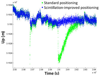
Calculated antenna height with (blue) and without (green) ionospheric scintil-lations mitigation (IONO+) activated
6) Resistance to ionospheric disturbance
We’re currently winding down from the last solar-activity peak in 2014. However, ionospheric disturbance of GPS signals are still problematic around the equator and at higher latitudes. Ionospheric scintillation mitigation ensures GPS output remains predictable and that RTK positioning is maintained.
More than shifting earth
Today, a wide variety of applications use GPS receivers. From seismic monitoring and timing to on-board dredgers and drones, GPS receivers provide high-precision positioning or timing when needed.
If your applications requires this level of precision, make sure you check out Septentrio's line of solutions at Unmanned Systems Source.

 UAS vendors targeting markets from commercial survey to agriculture are fielding systems with real-time kinematic GNSS (RTK) capability.
In principle, RTK promises accuracies at the 1-3cm level. The main purpose is to minimize or eliminate the need for ground control points, thereby reducing cost.
Altavian uses GNSS receivers upgradeable to RTK operation, but favors another approach for this level of accuracy: post-processed kinematic (PPK). There are a couple of reasons why:
UAS vendors targeting markets from commercial survey to agriculture are fielding systems with real-time kinematic GNSS (RTK) capability.
In principle, RTK promises accuracies at the 1-3cm level. The main purpose is to minimize or eliminate the need for ground control points, thereby reducing cost.
Altavian uses GNSS receivers upgradeable to RTK operation, but favors another approach for this level of accuracy: post-processed kinematic (PPK). There are a couple of reasons why:
 GPS receivers can assist operators in making better decisions by providing precise position information (indicate-only mode). Or the GPS receiver, as part of a guidance system, can take over the operation of the machine’s implement itself (fully-automatic mode) to follow a preloaded design.
In fully-automatic mode, the RTK centimeter-level precision of the GPS guidance system is far more accurate and consistent than relying on the operator’s skill alone.
Trenches are dug to exact depths, tractors are steered in perfect rows, piling rigs know the precise location for planting piles and surfaces are fine graded the first time. Work is completed quicker, more cheaply and to a higher specification when the need to carry out frequent measurements and surveys is not needed.
Compared to a Total Station, a GPS RTK system setup is quick and doesn’t require any of the elements to be in line of sight. A single reference base station can furnish all rover machines on-site continuously with RTK differential corrections. The status of the project and location of every machine on-site is updated in real-time giving site managers a full overview of progress.
GPS receivers can assist operators in making better decisions by providing precise position information (indicate-only mode). Or the GPS receiver, as part of a guidance system, can take over the operation of the machine’s implement itself (fully-automatic mode) to follow a preloaded design.
In fully-automatic mode, the RTK centimeter-level precision of the GPS guidance system is far more accurate and consistent than relying on the operator’s skill alone.
Trenches are dug to exact depths, tractors are steered in perfect rows, piling rigs know the precise location for planting piles and surfaces are fine graded the first time. Work is completed quicker, more cheaply and to a higher specification when the need to carry out frequent measurements and surveys is not needed.
Compared to a Total Station, a GPS RTK system setup is quick and doesn’t require any of the elements to be in line of sight. A single reference base station can furnish all rover machines on-site continuously with RTK differential corrections. The status of the project and location of every machine on-site is updated in real-time giving site managers a full overview of progress.