Tag - RTK

Inertial Labs Releases Affordable, Multi-GNSS Constellation, 1cm RTK Accuracy Dual-Antenna GPS-Aided INS

Inertial Labs, Inc., a developer and supplier of high performance Inertial Sensors and Systems, released an affordable, multi GNSS constellation, 1 cm RTK accuracy dual-antenna GPS-Aided Inertial Navigation System (INS).  

Affordable Dual-Antenna GPS-Aided INS

The INS-DL and the OEM version, INS-DL-OEM, are multi constellation -- GPS, GLONASS, GALILEO, Beidou -- GPS-Aided INS that achieve 1 cm Position and 0.05° Heading, Pitch & Roll accuracy. These high precision and high-accuracy INS are affordably priced at around $5,000 USD. The INS-DL and INS-DL-OEM are compact and deliver high performance. They are designed for developers of autonomous and unmanned systems; vehicles and small robots for precision agriculture; payloads for remote sensing and survey applications. The INS-DL is available as a classic INS or as an advanced, GPS-aided Motion Reference Unit (MRU). As a classic INS, it outputs Position, Orientation and IMU data for real-time and post-processing operation. As an advanced, GPS-Aided MRU, it outputs Position, Velocity, Heading, Pitch, Roll, Heave, Surge, Sway and Significant Wave Height data for survey, hydrography, bathymetry and motion control. "GPS-Aided INS-DL is a result of significant efforts of our R&D team. It is a market oriented solution, geared towards applications, requiring the best combination of high performance and in a same time low cost " said Jamie Marraccini, Inertial Labs’ CEO and President.  

About Inertial Labs

This year, Inertial Labs celebrate its 17th anniversary as a developer and supplier of high quality inertial sensor based solutions for  land, marine and aerospace applications. Since 2001, thousands of inertial systems, as well as those fused with other technologies like optical, laser, and GNSS systems, were successfully delivered to our customers for AGV, UAV, AUV, UUV, robots, land vehicles etc.  

Shop Inertial Labs line of solutions at Unmanned Systems Source.

PPK vs. RTK: When do you choose one over the other?

PPK vs. RTK
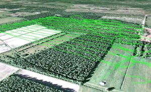
UAS vendors targeting markets from commercial survey to agriculture are fielding systems with real-time kinematic GNSS (RTK) capability. In principle, RTK promises accuracies at the 1-3cm level. The main purpose is to minimize or eliminate the need for ground control points, thereby reducing cost. 
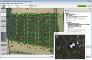
Altavian uses GNSS receivers upgradeable to RTK operation, but favors another approach for this level of accuracy: post-processed kinematic (PPK). There are a couple of reasons why:
  1. RTK requires a GNSS base station equipped with a transmitter with a reliable link to a fairly dynamic moving platform.
  2. The rover (on the UAS) itself requires a dedicated receiver for the corrections.
These primary reasons carry some further implications for the cost of deployment, especially when considered against PPK.  

PPK vs.RTK

RTK operations not only require a stationary base station, but it must be located at a known control point. Provided the base station is deployed for long enough periods of time, this is not too much of a problem. The base station’s precise location can be determined post-mission if no control points are already present. In this case, a global shift of the aircraft’s trajectory must be done once the position of the base station is determined, taking away some of the benefits of a ‘real-time’ solution. PPK requires a base station as well. But in many cases, at least in the Eastern US, the public CORS network may be dense enough to provide a base station reasonably close to your project. But, it’s likely you will need a base station of your own. This represents slightly less investment in an over-the-air link to the rover. However, it comes with the possibility of loss-of-lock.  

Losing Lock

In both RTK and PPK, when the rover loses lock, a new integer ambiguity resolution procedure must be initiated. The advantage of PPK is that the search can proceed from previous and future data relative to that instant. Additionally, forward and reverse solutions in PPK are optimally combined and give an estimate of a solution’s consistency. RTK solutions cannot use data that has not yet been recorded. If you want to eliminate ground control points and you chose an RTK system, there is no external information for basing accuracy estimates. Finally, it is worth noting that antennas light enough to be mounted on a small UAS are not geodetic-grade and are not likely calibrated for phase-center variation (PCV), let alone the actual location of the phase center. This means that you might get a reported solution accuracy of 2cm, but it could easily be very misleading. With a PPK solution, at least you can see if the forward and reverse solutions agree within certain bounds (and we acknowledge this is a very limited vote of confidence for any kinematic solution, but it’s better than nothing).  

Conclusion

Ultimately, there is no replacement for real ground truth, especially if your data product must be certified to a specific level of accuracy. However, strategies to minimize the requirements on GCPs can vary widely in their effectiveness, depending on your needs. If positional accuracies of a few decimeters are acceptable, real-time L-band corrections through a subscription service such as TerraStar-D are very attractive alternatives that require no base stations at all. You can find and shop Altavian's line of solutions at Unmanned Systems Source.

Hemisphere introduces the Vector Eclipse H328 a low-power, high-precision, position and heading OEM board

Hemisphere GNSS recently announced the Vector Eclipse H328, the next offering in the company’s line of new and refreshed, low-power, high-precision, positioning and heading OEM boards. The multi-frequency, multi-GNSS H328 is an all signals receiver board. It includes Hemisphere’s new hardware platform and integrates Atlas GNSS Global Correction Service.  

New hardware platform, higher performance

Designed with this new hardware platform, the overall size, weight, and power consumption of the H328 are reduced. It offers true scalability with centimeter-level accuracy in either single-frequency mode or full performance multi-frequency, multi-GNSS, Atlas-capable mode that supports fast RTK initialization times over long distances. The H328 offers fast accuracy heading of better than 0.17° at 0.5m antenna separation and aiding gyroscope and tilt sensors for temporary GNSS outages. The 60mm x 100mm module with 24-pin and 16-pin headers is a drop-in upgrade for existing designs using this industry standard form factor. The technology platform enables simultaneous tracking of all satellite signals including: GPS, GLONASS P-code, BeiDou, Galileo, and QZSS. This simultaneous tracking makes it robust and reliable. The updated power management system efficiently governs the processor, memory, and ASIC making it ideal for multiple integration applications. The H328 offers flexible and reliable connectivity. It supports Serial, USB (On-The-Go with future firmware upgrade), CAN, Ethernet,and SPI for ease-of-use and integration. It also supports optional output rates of up to 50 Hz.  

Vector Eclipse H328 accuracy

Powered by the Athena GNSS engine, the H328 provides centimeter-level RTK. Athena excels in virtually every environment where high-accuracy GNSS receivers are used. Environments include: open-sky environments, under heavy canopy, and in geographic locations experiencing significant scintillation. Together with SureFix, Hemisphere’s advanced processor, the H328 delivers high-fidelity RTK quality information that results in high precision and reliability. Integrated L-band adds support for Atlas GNSS global corrections for meter to sub decimeter-level accuracy while Tracer technology helps maintain position during correction signal outages. The H328 also uses Hemisphere’s aRTK technology, powered by Atlas. This feature allows the H328 to operate with RTK accuracies when RTK corrections fail. If the H328 is Atlas-subscribed, it will continue to operate at the subscribed service level until RTK is restored. The H328 is designed for robotics, autonomous vehicles, antenna pointing, marine survey, machine control, and any application where high-accuracy positioning and heading is required.   You can shop Hemisphere's line of products at Unmanned Systems Source.

Proven cm-level Precision Using UAVs

Septentrio_uavYour challenge, should you choose to accept it… You’ve been asked to survey some points on the ground with centimeter-level accuracy. Feeling confident? How about a few hundred points spread over 7.5 hectares (18.53 acres) and the job has to be done in one afternoon. Throw in the fact that the area you have to survey is in a quarry which has been closed off due to a recent landslide. Still feeling confident? You should and here’s why. Improvements in Unmanned Aerial Vehicle (UAV) technology combined with more compact high-end Global Navigation Satellite Systems (GNSS) receivers means that you no longer have to compromise on precision to measure in those hard-to-reach areas.  

Before the flight

image_uavUAVs have become more reliable and easier to work with: from programming flight paths to installing additional equipment on board, UAV applications are no longer confined to a limited group of specialists. 
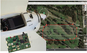
For a survey flight, your UAV will need to have installed: a high-resolution camera and a high-end GNSS receiver module. To fly the UAV through a pre-programmed flight plan, an autopilot flight controller is often included.    

The flight

The flight path shown below covered 7.5 hectares (18.53 acres) and was flown in 15 minutes. The 143 photographs taken during the flight were geotagged with GNSS standalone mode positions. Accuracies in standalone mode are typically around 1 to 4 meters (3.28 to 13.13 ft). If the on-board receiver receives correction information in real time from a nearby GNSS base station, it calculates positions using the more precise (centimeter-level) RTK mode. With the necessary data from a GNSS base station, RTK positioning can also be calculated ‘offline’ in the processing step using GeoTagZ as described below. Offline reprocessing using GeoTagZ removes the need for a real-time data connection between the UAV and base station which simplifies the hardware setup on the UAV and reduces the payload.   flight_path

Back in the office: Geotagging

The AsteRx-m UAS receiver recorded the times the photographs were taken by time-stamping a pulse signal from the camera shutter. It also recorded dual-frequency GNSS measurements during the flight. The GeoTagZ software uses the GNSS data recorded by the receiver and, combining it with the base station reference file, is able to calculate centimeter-level RTK positions for georeferencing the photographs.  The EXIF data of the photographs is then replaced with the more accurate RTK georeferences ready for image processing. In this example, GeoTagZ was able to match images with shutter events despite the receiver file covering a longer time period and so having more events than images.   With the photographs now stamped with a precise time and location, they can be processed. The blue crosses in the screenshot below are the ground locations of check points used to determine the final precision and accuracy. They play no part in the processing. This example details the use of Pix4D and PhotoScan however, other similar image processing tools could equally well have been used.   cropmap

What accuracy can you expect on the ground?

The photographs in this example were processed using two popular image processing software tools Pix4D and PhotoScan from Agisoft. The values highlighted below are the 3D-RMS values from their respective reports. These values are calculated from the sum of squared differences between each of the 20 check points’ surveyed positions and their positions as calculated using the image processing software. The 3D accuracies for both software tools are better than 3.5 cm, with the height (Z) being the largest contributor to the total error. This is the same accuracy that a human surveyor would typically reach when surveying each of the 20 points check points manually.

Pix4D


Agisoft PhotoScan

agisoft

GeoTagZ provides the missing link to centimeter-level ground mapping

The combination of high-resolution aerial photographs with GeoTagZ, for georeferencing with RTK positions from a compact high-end receiver module, provides the complete input for centimeter-level mapping precision on the ground. The same precision as manual survey can thus be achieved in a fraction of the time for all ground points within the surveyed area.