Industry News

BVLOS Demo Over Mobile Network

For the first time in the Baltic region, BVLOS conducted entirely on the mobile network

BVLOS Demo Over Mobile Network

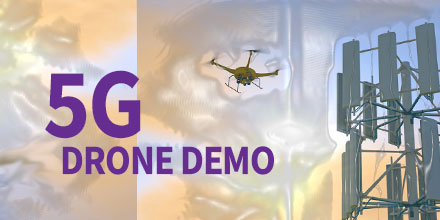
RIGA, LATVIA (EINPresswire.com) – Recently, 5G Techritory, the Baltic Sea Region 5G Ecosystem Forum, opened with a unique demonstration.

For the first time in the region, a BVLOS drone flight took place entirely via mobile network.

Throughout the demonstration, the drone seamlessly switched from one base station to another.

BVLOS Demo Over Mobile Network

The drone flight took place within the Adazi airport territory, 25 km away from the conference location.

Latvian Mobile Telephone (LMT) President Juris Binde and Prime Minister of the Republic of Latvia, Krišjānis Kariņš controlled the drone remotely.

Throughout the flight, LMT tested the strength of the mobile network.

The results showed that the network strength met 97.6% of the requirements for successful remote drone management.

“One of the most important issues was how to make 5G “fly” metaphorically speaking. It’s not a matter of building a network, that's the easy part,” said Binde. “What is not clear, however, is how to use this network for the needs and purposes of increasing competitiveness, productivity, for business and society.”

BVLOS Demo Over Mobile Network

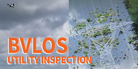
The industrial use of drone flights via mobile networks are varied.

A prime beneficiary of such technology is any infrastructure which requires frequent monitoring. This includes infrastructure, such as: gas and oil pipelines, power supply lines, seaports.

It is significantly cheaper and more effective to conduct these flights via mobile networks. Such inspections are possible with preset drone flights.

“When we decided to demonstrate a live flight approximately 20 km from here, many said we were crazy or brave,” said Binde. “To show something live is very risky. However, we are used to risk, because our mobile networks are live all the time.”

In order to ensure that the use cases are secure on a mobile network, the network must be tested for higher altitude data usage.

Repeatedly, LMT has demonstrated a strong mobile network. However, the challenge involved proving the network's strength above ground level.

The demonstration showed that safe, remote-controlled drone flights are possible.

In addition, LMT tested a tool which provides a prognosis of network coverage in the air.

The tool was a result of a collaboration with Austrian software developer, Dimetor. The tool provides an additional safety measure through drone flight path planning.

In support of the demonstration, SPH Engineering developed a pre-programmed and automated drone flight path.

SPH Engineering, also a Latvian company, developed the popular UgCS Mission Control Software.

The team tested the drone flight at various heights – ground level, 50m, and 120m in the air.

Demo Takeaways

There were several key takeaways as a result of the the demonstration.

For one, it reinforces the need to develop the infrastructure and laws necessary to make BVLOS drone flight a reality.

It also showed the safe and predictable flight of remote-controlled drones on automated flight paths.

The demonstration helps lay the foundation for additional research and expansion of use cases – first in industrial areas and, later, in smart city applications.

Future Possibilities

There is growing interest in autonomous BVLOS drone flight.

For example, LMT is collaborating with the Latvian State Forests, which must continually monitor their forests. To do so via drone means practically each flight path would be BVLOS.

Latvian State Forest has a variety of responsibilities, including: monitoring forest growth, illegal deforestation and looking out for wildfires. Additionally, they also monitor areas experiencing bark beetle infestations. In recent years, this infestation has led to significant losses in Europe’s forests.

LMT is no stranger to testing non-terrestrial mobile networks. In July of 2019, they set a record for the highest noted mobile network coverage, at 85,000 feet in the air (26 km).

As the strength of mobile networks increases, the applications are sure to follow suit.

Find out more and purchase UgCS Mission Planning Software at Unmanned Systems Source.

Sentaero v2VTOL Performs BVLOS Utility Inspection

Soaring Eagle Imaging Performs 51 Mile BVLOS Utility Inspection in 6 Hours Using Censys Technologies Sentaero v2VTOL

Sentaero v2VTOL Performs BVLOS Utility Inspection

Hurricane Barry made landfall in Louisiana on the afternoon of July 13, 2019. In the aftermath, critical infrastructure needed inspection, including power lines near Baton Rouge. With 25.5 miles of 500kV power lines as the target, it was imperative to expedite those inspections.

Growing Demand

Energy companies in the United States are under tremendous pressure to prepare for hurricanes. Every year, these companies spend hundreds of thousands of dollars to mitigate that risk. Even worse, with each threat it is never known if it is a false alarm or a natural disaster.

This past hurricane season, Soaring Eagle Imaging (SEI) served a major Louisiana energy provider. And, both parties reaped the benefits of their preparation.

SEI is a professional aviation organization and a partner/customer of Censys Technologies. The company utilizes unmanned technology for multiple inspection applications to serve a host of enterprise clients.

With 30,000+ manned aviation hours to accompany their 3,000+ UAS hours, SEI brings a strong safety culture to every operation. In total, SEI has been granted 17 emergency Beyond Visual Line of Sight (BVLOS) waivers.

“SEI is now positioned to safely perform BVLOS operations as a ‘normal’ daily mission," said CEO William Paden. “The experience gained proves SEI teams are exceptionally proficient in the tasks required to safely conduct these types of operations.”

Sentaero v2VTOL

SEI conducted BVLOS flights using a Censys Technologies Sentaero v2VTOL. Once determined that safe flights could be conducted, there were no remote visual observers.

In three missions, the single crew captured 51 miles worth of detailed information in 6 total hours of time in the field. This time included setup, tear-down, and transit.

The inspection helped quickly identify the scope of damage and corresponding locations. This vital data helped facilitate swift repairs.

“The level of professionalism from the entire Censys team is the reason our organization is able to continually set new standards in the UAV realm," said Paden. "The constant communication with the leadership and engineering team was instrumental in the aircraft performing to the level it did. Without Censys Technologies, SEI would not have been successful.”

BVLOS Demand

Currently, there are only 30 commercial entities with approved BVLOS waivers in the United States, making these flights rare.

“I’m ecstatic to see a great partner and customer of ours employ our technology with such an emphasis on safety to deliver exceptional value to energy asset owners. I could not be happier with the partnership we have in SEI, and I’m confident we’ll continue to set standards together," said Trevor Perrott, Censys CEO. "I’m grateful to the FAA for approving the operation without requiring remote visual observers. As the operation shows, the execution of BVLOS operations is both safe and economical.”

The entire line of Censys Technologies UAS and VTOL-hybrid solutions are now available at Unmanned Systems Source.

UKRSPEC Systems Integrates Veronte Autopilot onto PD-1 Platform

Embention is gaining a reputation among the UAV sector for providing robust autopilot solutions for both commercial and military applications.

Their flagship autopilot, Veronte, allows users to adapt and control the UAVs behavior in even the most demanding environments. Embention also provides efficient technical support for their customers.

Recently, UKRSPEC Systems collaborated with Embention. The collaboration focused on shared goals:  invest in innovation and efficiency and increase the use of UAV systems. The end result? Integration of the Veronte autopilot onto UKRSPEC’s PD-1 platform.

PD-1 Platform

The PD-1 platform is a unique UAV. It functions as a traditional fixed-wing but boasts VTOL capabilities, as well.

The PD-1 platform offers unique characteristics. Thanks to a fuel injection engine it offers high autonomy and robustness. Plus, its design enables users to quickly assemble the vehicle with minimal tools. It is a great solution for military environments and high-performance applications.

PD-1 is a highly reliable platform which fits well with Veronte autopilot. It achieves unique flight control, specific flight phases for each stage of the mission, as well as smooth transitions. There is even an option for advanced control of the payload.  

Veronte Autopilot

Manufactured and developed under rigid quality standards, the Veronte autopilot complies with DO-178C / ED-12 and DO-254 certification standards. Plus, IP67 standards. As such, it is the perfect complement for those developing total unmanned platforms.

Veronte allows advanced control of any kind of UAV VTOL hybrid aircraft. It facilitates fully-autonomous flight missions as well as adaptive control. The autopilot offers the reliability and robustness necessary for military operations.

Plus, a single Veronte Autopilot – either in its simple version or with triple redundancy – allows advanced and fully-automatic control of all phases of flight as well as a VTOLs vertical takeoff and landing.

Visit Unmanned Systems Source to learn more about Veronte Autopilots as well as the capabilities of the PD-1 Platform.

Successful BVLOS missions conducted by Aeromapper Talons

Recently, two units of amphibian Aeromapper Talons successfully conducted trials in beautiful Turneffe Atoll in Belize. The Zoological Society of London and the Turneffe Atoll Sustainability Association led the work.

The Turneffe Marine Protected Area (MPA) in Belieze was delineated in 2012. However, managing the MPA and protecting it from illegal fishing has proven difficult given its size and remote location. All of which contributed to high running costs.

Soaring costs

The current enforcement strategy on the Turneffe atoll involves patrols in small boats searching for illegal fishers. Unfortunately, systematic surveys for megafauna -- such as turtles, dolphins and sharks -- do not occur regularly. Instead, the conservation officers tend to document animals they happen across on their patrol.

Due to costs, patrols only cover a limited amount of territory. The drones proved to a be an exceptional low-cost solution to these challenges.  

Given the application, environment and desire to cut costs, the Aeromao's Talon Amphibious drone seemed a perfect solution. Capable of water-landing, the water-proof, long-range, fixed-wings came equipped with multi-cameras.

The mission involved monitoring and surveying marine megafuana, gathering evidence of illegal, unreported and unregulated fishing (IUU). Plus, conducting ecology research toward conservation efforts.

”The amphibious drone was able to fly to the site of interest at 110m altitude, gather intelligence and fly back very quickly. The images highlighted that indeed illegal building work had been occurring. Without the UAV the conservation officers would have no way of knowing this and they were very excited at this revelation”, states one of the conservation officers.

The conservation team found the front live-link HD camera an exceptional revelation. In one instance, it allowed them to spot a diving boat on the LCD screen -- something the team could barely see from land. The UAV can fly up to 90-minutes. That, in addition to flying at 62kph, means it travels considerable distance and area for surveillance.


BVLOS Operation

Additionally, the pair of drones repeatedly operated in Beyond Visual Line of Sight (BVLOS) scenarios. In total, the team conducted 24 sucessful BVLOS flights during the trials. The average length of 10.9km and with total transect lengths of 263km. 

The UAV reached a furthest point BVLOS of 11.3km. In a particular scenario, conservation officers wanted to scope out a development site several kilometers away. The team hoped to use the drones BVLOS capabilities to detect any infringement of their building contract.

The Talon amphibious drone was able to fly to the site of interest at 110m altitude, gather intelligence and fly back very quickly. The images and video showed that, indeed, illegal building work was occurring. Without the UAV the conservation officers would have no way of knowing this; they were very excited at this revelation.

“We now have the tool we need to see further and faster than before. No one will see us coming!” said Maurice, a conservation officer.

During flight, the 20mp nadir camera either captured 5 images per second, or stunning HD film. The front camera, which panned left to right, filmed and recorded a live stream. This allowed the conservation officers to monitor what was happening in real time.

Although the drones normally fly on pre-designed routes in auto mode, switching to “assisted mode” allows operators the flexibility to investigate something of interest.

For instance, if fishers are in an off-limits zone, operators can quickly re-route the drones. Operators can get additional pictures, loiter and provide continuous surveillance around the point of interest.

If images capture dolphins, the team can redirect the drones, capture additional pictures and use the images to estimate area population. Mapping of habitats, using the nadir camera was also possible. Some areas of coral reef and seagrass beds were mapped using Agisoft Metashape.  


Static-launch capability

Several static launches of the UAV from a small, moving skiff were also successfully performed. Such launches are unheard of for a fixed wing – long range amphibious unmanned aircraft. This is a tremendously important, and previously unknown ability of the UAV.

This capability allows conservation officers to steam to an area even when a beach for launching may not exist. Instead, operators can simply launch from the boat. Once the mission is over, the drone simply lands on the water besides the skiff for retrieval.


Mission success

During the surveys, the drones gathered impressive geo-referenced images of turtles, sharks, eagle rays, manatees, and birds. These images helped identify environmental issues such as plastic debris and sargassum seaweed which causes deoxygenation of the water and blocks out sunlight.

Using the data, the team built spatial pictures of how both fishers and fauna use the atoll. This information helps ecologists identify marine protected zones.

The scientists leading the expedition stated that having a UAV which can safely land on the ocean and quickly re-deploy in moments, is an exceptionally valuable tool.

Conservation officers in the Turneffe Atoll are adamant that a UAV like the ones trialed, will become an essential part of the patrol and enforcement strategy.

Read full report Case Study and Technical Report here: https://www.aeromao.com/2019/08/02/aeromapper-talon-amphibious-routinely-fly-bvlos-missions-over-marine-reserve-for-illegal-fishing-detection-and-biodiversity-research/

Shop the entire line of Aeromao's fixed-wing solutions at Unmanned Systems Source.

Aeromao Receives Compliant UAV Status with Transport Canada

Canadian company Aeromao recently announced that the Aeromapper line of commercial grade drones are now on the list of compliant UAV systems of Transport Canada. This distinction allows Canadian organizations using Aeromapper drones to apply for Compliant Operator status. The list includes Aeromao's four drone systems:
  • Aeromapper Talon
  • Aeromapper 300
  • Quad Mapper VTOL
  • Nano Mapper
The Quad Mapper VTOL and Nano Mapper represent new UAV systems from Aeromao and will soon release to market. The Quad Mapper VTOL is a fixed-wing system with Vertical Take-Off and Landing (VTOL) capabilities. The Nano Mapper is a sub 1Kg fixed-wing drone designed for agricultural applications. In addition, two more variants of the Aeromapper Talon are currently awaiting confirmation from Transport Canada: Aeromapper Talon Amphibious and Aeromapper Talon LITE. Once confirmed, these models will be on the list of compliant drones. “Aeromao’s UAV solutions officially meet Transport Canada’s standards of safety and efficiency,” said Mauricio Ortiz, CEO of Aeromao. “We are truly excited to continue assisting Canadian and foreign customers with their drone programs, not only by ensuring that our systems continue meeting the latest regulatory policy changes but also by diversifying our line of commercial drone systems that fit all customer requirements and budgets.” Over the years, the Aeromappers have demonstrated a history of safe operation in some of the harshest environmental conditions in countries around the world.

Shop Aeromao's line of UAVs at Unmanned Systems Source.

About Aeromao Inc. Is the Canadian leading UAV solutions provider and manufacturer, developer of the Aeromapper series of turnkey unmanned aerial vehicles for mapping, surveying, precision agriculture, remote sensing, inspection and surveillance.

UgCS Introduces the Automatic Vertical Scanning Tool for Drone Inspection Mission Planning

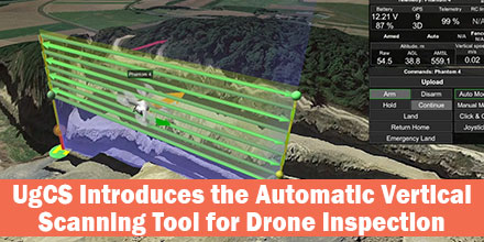
UgCS's new automatic Facade Scan tool for drone inspection mission planning is a time and cost saver for construction, engineering and mining industries. Tools for surveying horizontal surfaces — even uneven ones — are widely available on the market and have been for some time. However, inspecting vertical surfaces is a completely different story.  Previously, vertical surface inspection was a burden for professional drone users because it required a lot of manual work. But, thanks to the automatic Facade Scan tool from UgCS, that burden is no more.  

Vertical Scan Tool

The new Facade Scan tool has many applications for construction, architecture and other industries. The tool creates accurate digital models of buildings or cultural heritage objects. Plus, it identifies heat leaks and damage to walls. Facade Scan allows the drone operator to draw a vertical plane, specify the distance to the wall as well as side and forward overlap. Once complete, it automatically calculates the optimal flying path. UgCS also supports the import of 3D objects and custom DEM data using the terrain-following function.  

Mining Applications

The tool makes it possible to examine open quarries for mining applications. These inspections via drone provide cost savings measures and keep humans from dangerous work.  Drones can survey even unstable pits from a safe distance; the data gathered is much more accurate compared to other methods that don’t involve workers climbing down the pit. As mines often change due to work and natural conditions, repeated drone inspections bring data up-to-date in a fast and convenient way. “With its choice of automatic and manual tools, UgCS is extremely versatile and suitable even for the most specific needs,” says one mining professional. “We can use several different drones for the same mission, or a number of different drones with different kinds of sensors. If a drone runs out of battery, there is no need to start a new mission — it can be resumed where it was interrupted. We also appreciate the terrain following mode that allows drones to follow the surface accurately. We use it for both horizontal and vertical surveys.” Facade scan is part of the UgCS 3.2 release. It joins the family of other automatic UgCS tools: the Photogrammetry tool, Search Pattern tool and Area scan. It is available under a lifetime license, or a subscription based license of 1 and 3 months. UgCS supports most DJI drones, as well as MAVLink compatible and other UAVs. SPH Engineering continues to support and update the Facade Scan tool and welcomes comments from professional drone users across all industries.   Find out more about UgCS Mission Planning Software at Unmanned Systems Source.