From their military origins a few decades ago -- carrying sophisticated systems and running remote, cross-boarder missions -- drones are now commercial and industrial platforms.
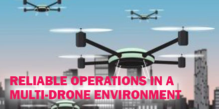
Today, drones play a significant role in the next generation of automated and autonomous vehicles. The vision of multiple drones filling in the public sky, running various missions smoothly is slowly becoming a reality.
Operational Reality
In fact, drone operation in such an environment is so challenging that stable and reliable communication is crucial.
The communication infrastructure must provide carrier-class availability, ensuring control and telemetry signals are available in real-time. And, that critical data flows between the drone and operation control centers.
In addition, automated airspace management systems must guarantee full coordination between different vehicles using the same air space. These systems are called UTM (Unmanned Traffic Management) systems.
The dynamic nature of the drone’s operation should have a ‘network’ planning perspective rather than a ‘link’ based perspective. All drones utilize RF (radio frequencies) to communicate with their respective ground stations and, eventually, with each other.
As frequency bands and channels are scarce and are also used by other platforms such as Wi-Fi systems, interference is the major obstacle for reliable communication. The more drones in a given area, the more fragile each link becomes due to other system interference. This poses a significant challenge for inter-operability of multi-drones in a given environment.
Communication Challenges in a Multi-Drone Environment
For example, the delivery market is one of the most complex drone applications. It requires running multiple drones in parallel, by different service providers. Some of the related communication challenges include:
- Near-End Interference – generated by other drones launched from the same or nearby network operating centers.
- Far-End Interference – generated closer to the landing area, from Home Routers such as WIFI or other systems operating nearby such as agriculture drone systems.
- In-Flight interference – from other drones flying nearby, Radio Control (RC) recreational vehicles.
- BVLOS operation – flying in an urban area can generate signal loss and fading due to high-rise buildings and other obstacles.
- Terrain Obstacles – rural operation may introduce signal fading due to Fresnel zone blocking by a hilly terrain.
- Interoperability with mobile networks – utilizing dual combined communication can increase reliability but must include a smooth switch-over mechanism when the public network is congested or out of reach.
Each challenge is complex and requires a different solution.
However, the overall requirements from a drone communication system operating in a crowded sky must include dynamic configuration, fast response to changes and transparency to the user. Eventually, the entire operation will be fully automated from takeoff to landing.
Solutions for Reliable Operation in a Multi-Drone Environment
There are different solutions for overcoming these and other challenges.
Some relate to the core technology utilized by the communication systems themselves, such as features that can guarantee higher reliability due to diversity and redundancy.
Others relate to switch-over mechanisms between different technologies, utilizing the LTE/5G networks for long range urban operation for example. Minimizing interference on one hand, and greater immunity to interference by switching frequencies in-flight on the other hand, are also crucial for a secured safe operation.
By integrating and adopting such capabilities as a standard by the drone operator’s community, alongside with administrative and airspace usage coordination systems, we can overcome many of above challenges and guarantee a reliable and safe operation in a multi drone environment.

 Pilots of unmanned aircraft who interfere with first responder efforts are now more likely to face serious civil penalties...even for first time offenses.
Recently, the Federal Aviation Administration (FAA) released guidance (PDF) for agency personnel who handle possible drone violations.
Now, all cases involving interference with first responder operations are referred to the FAA Chief Counsel’s office for possible enforcement action.
Pilots of unmanned aircraft who interfere with first responder efforts are now more likely to face serious civil penalties...even for first time offenses.
Recently, the Federal Aviation Administration (FAA) released guidance (PDF) for agency personnel who handle possible drone violations.
Now, all cases involving interference with first responder operations are referred to the FAA Chief Counsel’s office for possible enforcement action.
 The Spanish UAV manufacturer, Alpha Unmanned Systems will present the Alpha 800, gasoline-powered helicopter UAV, at NATO’s Trident Juncture exercise in Trondheim, Norway.
From October 25th to November 7th, a live field exercise will take place, spanning air, sea and land areas of Norway. 45,000 participants from 31 nations are deployed for the event.
During the exercise Alpha Unmanned will take part in the Enhanced Logistical Base demonstration, where leading players will show the future of military logistics.
Alpha Unmanned Systems will exhibit its Alpha 800 helicopter UAV. The Alpha 800 is a tactical 14 kg gasoline powered helicopter that provides 2.5 hours of continuous flight with a 3 kg payload and 30 km of operating range. It is equipped with the lightest and strongest airframe in its class and a military-grade autopilot with high precision GPS and sensors. It is well suited for surveillance and for the delivery of urgently needed supplies.
The Trident Juncture 2018 is an excellent event to carry out complex air operations, and it’s a great chance to highlight the Alpha 800, a reliable UAV platform “Made in Spain” and designed for hard work in challenging and complex environments.
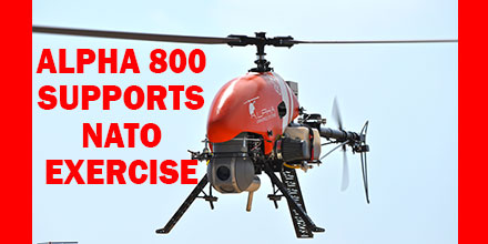
The Spanish UAV manufacturer, Alpha Unmanned Systems will present the Alpha 800, gasoline-powered helicopter UAV, at NATO’s Trident Juncture exercise in Trondheim, Norway.
From October 25th to November 7th, a live field exercise will take place, spanning air, sea and land areas of Norway. 45,000 participants from 31 nations are deployed for the event.
During the exercise Alpha Unmanned will take part in the Enhanced Logistical Base demonstration, where leading players will show the future of military logistics.
Alpha Unmanned Systems will exhibit its Alpha 800 helicopter UAV. The Alpha 800 is a tactical 14 kg gasoline powered helicopter that provides 2.5 hours of continuous flight with a 3 kg payload and 30 km of operating range. It is equipped with the lightest and strongest airframe in its class and a military-grade autopilot with high precision GPS and sensors. It is well suited for surveillance and for the delivery of urgently needed supplies.
The Trident Juncture 2018 is an excellent event to carry out complex air operations, and it’s a great chance to highlight the Alpha 800, a reliable UAV platform “Made in Spain” and designed for hard work in challenging and complex environments.
 The Federal Aviation Administration (FAA) announced nine new partners to its
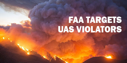
  If you fly your drone anywhere near a wildfire, you could get someone killed.
That’s the stern warning the Federal Aviation Administration (FAA) and U.S. wildland fire agencies have for pilots of unmanned aircraft who interfere with fighting wildfires.
Unauthorized drone flights are a serious risk to first responders and anyone in the fire’s path.
If you fly your drone anywhere near a wildfire, you could get someone killed.
That’s the stern warning the Federal Aviation Administration (FAA) and U.S. wildland fire agencies have for pilots of unmanned aircraft who interfere with fighting wildfires.
Unauthorized drone flights are a serious risk to first responders and anyone in the fire’s path.
 The U.S. Army recently announced the selection of Raytheon's Coyote unmanned aircraft system and the Ku-band Radio Frequency System (KRFS) radar, to counter the escalating threat of enemy UAVs in the skies above the battlefield.
Equipped with an advanced seeker and warhead, the Coyote-enabled system can successfully identify and eliminate threat UAVs when paired with an advanced electronically scanned array KRFS radar, which acquires and accurately tracks all sizes of UAS threats.
“Enemy unmanned aircraft are among the biggest threats facing our ground troops today,” said Dr. Thomas Bussing, Raytheon Advanced Missile Systems vice president. “Our small, expendable Coyote provides the Army with an affordable and highly effective solution for countering the growing UAS threat.”
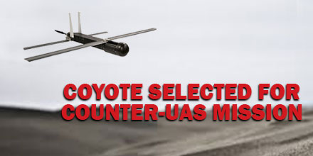
The U.S. Army recently announced the selection of Raytheon's Coyote unmanned aircraft system and the Ku-band Radio Frequency System (KRFS) radar, to counter the escalating threat of enemy UAVs in the skies above the battlefield.
Equipped with an advanced seeker and warhead, the Coyote-enabled system can successfully identify and eliminate threat UAVs when paired with an advanced electronically scanned array KRFS radar, which acquires and accurately tracks all sizes of UAS threats.
“Enemy unmanned aircraft are among the biggest threats facing our ground troops today,” said Dr. Thomas Bussing, Raytheon Advanced Missile Systems vice president. “Our small, expendable Coyote provides the Army with an affordable and highly effective solution for countering the growing UAS threat.”