Tag - BVLOS

Sentaero v2VTOL Performs BVLOS Utility Inspection

Soaring Eagle Imaging Performs 51 Mile BVLOS Utility Inspection in 6 Hours Using Censys Technologies Sentaero v2VTOL

Sentaero v2VTOL Performs BVLOS Utility Inspection

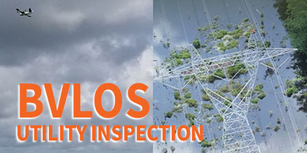
Hurricane Barry made landfall in Louisiana on the afternoon of July 13, 2019. In the aftermath, critical infrastructure needed inspection, including power lines near Baton Rouge. With 25.5 miles of 500kV power lines as the target, it was imperative to expedite those inspections.

Growing Demand

Energy companies in the United States are under tremendous pressure to prepare for hurricanes. Every year, these companies spend hundreds of thousands of dollars to mitigate that risk. Even worse, with each threat it is never known if it is a false alarm or a natural disaster.

This past hurricane season, Soaring Eagle Imaging (SEI) served a major Louisiana energy provider. And, both parties reaped the benefits of their preparation.

SEI is a professional aviation organization and a partner/customer of Censys Technologies. The company utilizes unmanned technology for multiple inspection applications to serve a host of enterprise clients.

With 30,000+ manned aviation hours to accompany their 3,000+ UAS hours, SEI brings a strong safety culture to every operation. In total, SEI has been granted 17 emergency Beyond Visual Line of Sight (BVLOS) waivers.

“SEI is now positioned to safely perform BVLOS operations as a ‘normal’ daily mission," said CEO William Paden. “The experience gained proves SEI teams are exceptionally proficient in the tasks required to safely conduct these types of operations.”

Sentaero v2VTOL

SEI conducted BVLOS flights using a Censys Technologies Sentaero v2VTOL. Once determined that safe flights could be conducted, there were no remote visual observers.

In three missions, the single crew captured 51 miles worth of detailed information in 6 total hours of time in the field. This time included setup, tear-down, and transit.

The inspection helped quickly identify the scope of damage and corresponding locations. This vital data helped facilitate swift repairs.

“The level of professionalism from the entire Censys team is the reason our organization is able to continually set new standards in the UAV realm," said Paden. "The constant communication with the leadership and engineering team was instrumental in the aircraft performing to the level it did. Without Censys Technologies, SEI would not have been successful.”

BVLOS Demand

Currently, there are only 30 commercial entities with approved BVLOS waivers in the United States, making these flights rare.

“I’m ecstatic to see a great partner and customer of ours employ our technology with such an emphasis on safety to deliver exceptional value to energy asset owners. I could not be happier with the partnership we have in SEI, and I’m confident we’ll continue to set standards together," said Trevor Perrott, Censys CEO. "I’m grateful to the FAA for approving the operation without requiring remote visual observers. As the operation shows, the execution of BVLOS operations is both safe and economical.”

The entire line of Censys Technologies UAS and VTOL-hybrid solutions are now available at Unmanned Systems Source.

Altavian Announces Work with NASA at UAS Test Site

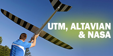
Altavian, recently announced that it is working with Northern Plains UAS Test Site (NPUASTS). The reason? Altavian is helping to test NASA's Unmanned aircraft systems Traffic Management (UTM) system. Altavian and NPUASTS are developing technology related to UTM. Additionally, a third partner, iSight RPV Services, is providing flight test services on the Nova F7200 sUAS.  

UTM History

In recent years, NASA has worked with technology leaders in the sUAS industry to develop a UTM system which safely integrates drones into the national air space. A UTM is integral to regulating drones on a national level, as well as beyond visual line of sight (BVLOS) operations.  

Developing UTM Technology

Altavian is hard at work developing dual communication systems for the Nova F7200. Point-to-point radio frequency communication is the most common method for sUAS-to-operator communication. Currently, nearly every drone uses point-to-point. This technology is optimal for high-rate aircraft telemetry or payload links, such as HD video. However, it has limitations when the sUAS is flown further away from the operator. By implementing a satellite link, the sUAS can send low-rate telemetry messages back and forth to the operator anywhere in the world. As such, the sUAS's range is no longer limited by local radio frequency. In parallel to this, Altavian is updating its Ground Control Station software, Flare, to communicate with the updated UTM system. Previously, Altavian and NPUASTS conducted flight tests with Technical Capability Level 1 in early 2016. The upcoming tests are the third iteration of the UTM system. By integrating Flare with the new UTM system, NASA is able to see where Altavian aircraft are at all times during testing. This developing technology could prove invaluable to preparing Altavian sUAS for future BVLOS operations. The project will continue into April 2018.   Shop Altavian's line of vehicles at Unmanned Systems Source.  

About Altavian, Inc.

Altavian designs and manufactures high quality drones to carry the best sensors into the toughest environments. Our drones feature modular systems to carry custom and integrated payloads to specialize any drone for any type of data. Our focus is on systems that collect data with the highest integrity and accuracy.  

MicroPilot Integrates Autonomous Sense & Avoid System for UAV Operations

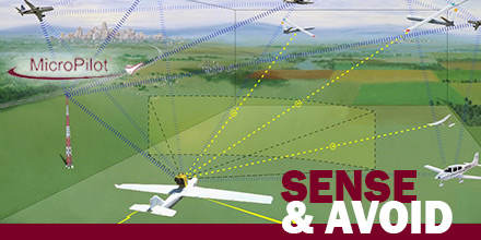
MicroPilot announced the successful integration of FLARM’s Sense and Avoid system with its autopilot. This integration grants clients a reliable autonomous collision avoidance option for fully autonomous UAV operations. With any form of autonomous vehicle, a primary concern is safely avoiding collisions with other craft...without the need for human intervention. A sense and avoid system allows a UAV to do exactly that. Thus, it dramatically reduces operational risks and the need for human monitoring.  

What is FLARM?

FLARM is a traffic awareness and collision avoidance technology used by light aircraft and UAVs. When integrated with MicroPilot’s autopilot, the system alerts the autopilot of nearby aircraft, along with its velocity and altitude. The autopilot uses the information to avoid the aircraft. Thus, it autonomously prevents a collision without a single input from the human operator. With increasingly crowded airspace and the popularity of UAVs, a reliable sense and avoid system is quickly becoming a necessity. This is especially true for beyond visual line of sight (BVLOS) and other autonomous operations. This new system should give operators the confidence to use their UAVs to the full extent of their abilities. “FLARM has been in use for over a decade helping manned aircraft avoid midair collisions,” says FLARM. “We are very happy to see that UAVs are the next type of vehicle that benefit from FLARM, and that UAVs are becoming visible to manned aircraft.”  

Sense and Avoid technology

This integration may give UAV manufacturers the confidence to market larger and longer-range UAVs. Consequently, it also gives operators the confidence to conduct long-range BVLOS operation. Combined, this technology furthers the utility and viability of UAVs.  

About MicroPilot

Started in 1994, with 1000 clients in over 85 countries, MicroPilot is the world leader in professional autopilots for UAVs and MAVs. MicroPilot offers a family of lightweight UAV autopilots that can fly fixed-wing, transitional, helicopter, and Multirotor UAVs. MicroPilot also provides complementary products such as the XTENDERmp SDK, and trueHWIL2.   Shop MicroPilot's line of autopilots at Unmanned Systems Source.

Aeromapper Talon successfully completes BVLOS mission over 30Km away

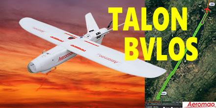
Recently, Aeromao's Aeromapper Talon successfully completed an autonomous mission to a target located 30km away. The Talon maintained strong communications and its control link throughout the entire mission. This mission successfully demonstrated the potential for Beyond Visual Line of Sight (BVLOS) operations for the Talon. The Aeromapper Talon costs only a fraction compared to systems with similar capabilities.  

Aeromapper Talon Demonstrates BVLOS

The Aeromapper team carried out the mission in the Andes Mountains of South America. The location of the flight was situated at 2,800m above sea level. The flight had a cruise altitude of 250m agl. Fifty percent of the flight traversed a body of water. The Talon traveled a total distance of 60km in its one hour flight. With a flight endurance of 2-hours, the Talon had enough flight time left to travel an additional 30km. However, the operators decided to bring the UAV back due to peaks in excess of 3,500 m above sea level in the flight path. Currently, the team is planning a future mission to demonstrate 50km reach capabilities. Aeromao's Aeromapper 300 also uses the same long range communication system as the Talon. The demand for BVLOS missions continues to grow throughout the industry. Applications for such missions include: power line and pipeline monitoring, roadways survey, surveillance and wildlife control, as well as long linear missions.  

Powerful solution for linear mission challenges

"We receive many requests from clients who need to fly linear missions sometimes to survey thousands of kilometers of pipelines, power lines or roadways," said Mauricio Ortiz of Aeromao. "We ourselves have completed hundreds of kilometers of linear projects, and know very well the challenges of these types of operations." The Aeromapper Talon is proving a solid solution given the specific capabilities demanded for these applications. Aeromapper Talon performs well in all:
  • Ability to operate in difficult terrain and with a mobile GCS with reliable and strong communications.
  • Quick deployment and easy operation: the Aeromapper Talon is flight ready in 15 minutes. It is one of the easiest UAVs to operate.
  • Several cycles of takeoff and landings per day from different locations: here the hand-launch and parachute landing are pretty much a MUST have. A large area survey needs the flexibility of operating from virtually anywhere.
  • Reliable and easy to repair in the field, as well as affordable with interchangeable spare parts.
 

Complete UAV solution, multiple fronts

Additionally, the Aeromapper Talon is also a multi-mission payload complete solution. It is a great choice for various applications, such as agriculture, centimeter accurate surveys, surveillance, and monitoring. Payloads available include:
  • 24 Mp RGB + with Parrot Sequoia simultaneously: complete full surveys at high resolution and get vegetation data in a single flight.
  • 24 Mp RG + Thermal Infrared: Ideal for pipeline or wildlife monitoring.
  • Forward looking day / night payload: An affordable surveillance and observation platform with long range video streaming. All systems are easily swappable.
  • Micasense RedEdge: A swappable payload option with serious agriculture power.
  • GNSS PPK: Eliminates GCPs and achieves up to 3 cm of accuracy for engineering projects. Also available as a swappable payload.
  • Pix4DMapper Aeromao Edition: serious post processing power with the most exhaustive power available. In an affordable bundle package with the complete UAV system.
  • Agisfot Photoscan Pro: Affordable and flexible post processing software to become a post-processing Ninja.
  Shop Aeromao's entire line of affordable UAV solutions at Unmanned Systems Source.