 Canadian company Aeromao recently announced that the Aeromapper line of commercial grade drones are now on the list of compliant UAV systems of Transport Canada. This distinction allows Canadian organizations using Aeromapper drones to apply for Compliant Operator status.
The list includes Aeromao’s four drone systems:
The Quad Mapper VTOL and Nano Mapper represent new UAV systems from Aeromao and will soon release to market.
The Quad Mapper VTOL is a fixed-wing system with Vertical Take-Off and Landing (VTOL) capabilities. The Nano Mapper is a sub 1Kg fixed-wing drone designed for agricultural applications.
In addition, two more variants of the Aeromapper Talon are currently awaiting confirmation from Transport Canada: Aeromapper Talon Amphibious and Aeromapper Talon LITE. Once confirmed, these models will be on the list of compliant drones.
“Aeromao’s UAV solutions officially meet Transport Canada’s standards of safety and efficiency,” said Mauricio Ortiz, CEO of Aeromao. “We are truly excited to continue assisting Canadian and foreign customers with their drone programs, not only by ensuring that our systems continue meeting the latest regulatory policy changes but also by diversifying our line of commercial drone systems that fit all customer requirements and budgets.”
Over the years, the Aeromappers have demonstrated a history of safe operation in some of the harshest environmental conditions in countries around the world.
About Aeromao Inc.
Is the Canadian leading UAV solutions provider and manufacturer, developer of the Aeromapper series of turnkey unmanned aerial vehicles for mapping, surveying, precision agriculture, remote sensing, inspection and surveillance.
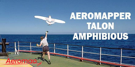
 In May 2018, an expedition to the British Indian Ocean Territory launched to study the distribution of megafauna across the Chagos Archipelago. Melissa Schiele, MSc student from Imperial College London, joined the expedition. Schiele also brought an amphibious drone — the Aeromapper Talon — to conduct the surveys.
“I was thrilled when Dr. Tom Letessier from Zoological Society of London (ZSL) chose me to help with his drone research as part of the Bertarelli Programme in Marine Science,” said Schiele. “Our plan was to survey some of the islands of the Chagos Archipelago to compare distributions of megafauna around islands with nesting birds to islands with invasive rats.”
To accomplish this task, Schiele researched possible drones.
“To our knowledge, no one had a fixed-wing water landing drone,” said Schiele.
Fortunately for Schiele, there was one such drone that fit the bill — the amphibious Aeromapper Talon manufactured by Aeromao Inc.
The use of Unmanned Aerial Vehicles (UAV) or drones, is gaining traction in the world of ecology and conservation. In marine environments, scientists are testing the feasibility of drones to locate megafauna as well as map large areas. Initial results are promising across the board.
Many are looking to drones to bridge the gap between ground truthing surveys (diving transects, etc.) and large-scale plane based surveys, which cover thousands of kilometers.
“In April 2018, I flew to Aeromao headquarters in Canada to learn how to fly our new drones. Aeromao created the Talon – a waterproof fixed-wing drone capable of flying huge distances with the strength, stability and mechanisms of a small plane. With a two-meter wingspan, the units looked impressive. After a week of training and a successful water landing on Lake Erie, I packed up the two drones and flew from Toronto to the Maldives.”
“Our first deployment and retrieval of the Talon was a success. Plus, we captured our first aerial footage,” said Schiele. “The drones were equipped with two cameras. One was on the belly of the fuselage; it took snapshots every second. The other camera was in the clear nose cone. It allowed live streaming of the drone flight to a screen used by the drone pilot. The images proved our original concept worked and we were able to pin point sharks, birds and large fish.”
Overall, the Talon performed well. There were some small water entry points which is being addressed. We also lost a few days to poor weather. For safety reasons, we did not fly in strong winds and there was little sense flying in rain.
By the end of the three-week expedition, we had a suite of images and two drones in need of some TLC.
This expedition is just the beginning of a very exciting, international effort into the use of water landing drones for use in marine ecology. We are learning from any mistakes we make and becoming deft at drone mechanics, too,” said Schiele.
The Amphibious version of the Aeromapper Talon allows maritime operations by autonomously belly landing on water. Learn more about the Talon Amphibious and shop the entire line of Aeromapper UAVs at Unmanned Systems Source.
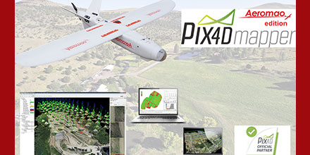 In celebration of its fourth year as an official partner of Pix4D, Aeromao has special offers on Pix4DMapper Aeromao edition and other Pix4D related products.
These offers expire December 31, 2018.
The Pix4DMapper Aeromao Edition is a fully featured image processing software package that is bundled with any Aeromapper UAV system. The package includes two perpetual licenses.
In addition, this bundled offer provides more savings than if purchased separately.
For example, the Aeromapper Talon — Aeromao’s flagship UAV system — sells for less than $16,000 USD. Now, this price includes the Pix4DMapper Aeromao edition, as well.
The Aeromapper Talon is a fixed-wing commercial turnkey UAV system. It is ideal for large area mapping, Beyond Visual Line of Sight (BVLOS) operations and optional Post-Processed Kinematic (PPK) for survey-grade results. It includes a wide range of optional swappable sensors: thermal, multispectral as well as surveillance camera packages.
Additionally, Aeromao offers stand alone licenses, educational packages or volume discounts in a quick turnaround time.
Since 2013, Aeromao has been an official partner and reseller of Agisoft Photoscan and all its related products.
Aeromao is Canada’s leading UAV manufacturer and developer of the Aeromapper series of turnkey unmanned aerial vehicles. With exports to more than 45 countries since 2012, Aeromao Inc. offers a line of products that adapt very quickly to market demands and to unique client’s applications, where no other UAV manufacturer goes.
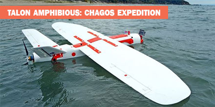
 The Aeromapper Talon Amphibious by Aeromao is the world’s first fixed-wing drone for commercial maritime operations that can belly land on water or parachute down.
With its dual cameras and 20km video link, it’s the perfect solution for observation, data collection and mapping.
There are very few Unmanned Aerial Vehicles (UAV) or drones that safely land on water. Thus the Talon Amphibious, with its watertight design, is a welcome solution for all UAV maritime and freshwater applications. Even better, this amphibious unit is affordable and multi-functional. Plus, true to its fixed-wing design, it offers extended flight time, substantial payload capacity, and extensive range.
The UAV is simple to retrieve from the water using a small boat. Or, the operator can land on a beach. With a cruise speed of 60kph, +30km communication range and 2-hour flight endurance, it easily covers vast areas. As such, it saves both money and time. Plus, its internal GPS beacon makes locating and retrieving the UAV easy.
The Talon Amphibious is quick to assemble and deploys by hand-launch from the shore or from a maritime vessel without disruption to the GPS system.
Its waterproofed fuselage and internal marine-grade components that resist saltwater corrosion, make the Talon Amphibious system uniquely suited to life on the water.
There are a range of customization options available for the Talon.
The Talon Amphibious underwent extensive testing in some of the most challenging marine conditions.
Original design inspiration for the UAV came from marine ecologist and field biologists. Their work conditions include maritime vessels and remote island locations. And though these locations may appear idyllic, they present many logistical problems and constraints when it comes to gathering data. Scientists needed a UAV which could endure harsh environments such as rain, wind and waves.
The Talon successfully completed operations in the British Indian Ocean Territories (BIOT) as part of a scientific expedition led by the Zoological Society of London. This is the first time that a fixed-wing amphibious UAV was used in the UK Overseas Territories. The applications of a water landing unit in marine ecological surveys, fisheries management and maritime surveillance are vast.
In addition, an MSc student from Imperial College London piloted and tested the amphibious UAV. He described the unit as: “An incredible tool for gathering vast amounts of ecological and habitat data, safe in the knowledge that we can easily land anywhere near the main vessel or on the ocean. In the tropics, rain clouds can often hit out of nowhere, and with this amphibious UAV, we no longer have to worry about rain water leaking in, either.”
Over 25,000 images were collected during the ecological surveys and the scientists were able to analyse the images to calculate the abundances of sharks and birds. Their camera of choice was the Garmin VIRB which allowed for geotagging of each image.
The Talon Amphibious is garnering plenty of interest in the research world. Scientists and managers from around the world are looking to implement this maritime solution into their coastal project operations.
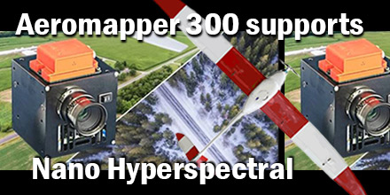 Recently, Aeromao Inc., delivered an Aeromapper 300 to the University of Brasilia in Brazil. The customized UAV arrived ready to integrate the Nano-Hyperspectral camera from Headwell Photonics.
After initial approval, the team completed the custom integration in just a few weeks.
When it comes to finding a UAV dependable enough to trust such an expensive sensor, the Aeromapper UAV line, from Aeromao, are an obvious choice. The UAV’s are affordable, dependable, easy to use, offer parachute recover, and a great level of customer support.
In addition, the payload bay of the Aeromapper 300 enclosed the Nano hyperspectral camera. Thus, protected by the carbon fiber/Kevlar pod of the aircraft. The Aeromapper 300 comes with a quick swappable mount which can accommodate other sensors, as well as the RGB 24 Mp camera, included.
The Headwall’s Nano-Hyperspec® sensor is a completely integrated hyperspectral camera designed for the VNIR (400-1000nm) spectral range, with interchangeable lens capability. Plus, a key advantage of the Nano-Hyperspec is that it also includes 480GB of on-board data collection/storage, plus attached GPS/IMU functionality.
Basic Specifications:
Aeromao Inc., a Canadian company, is the manufacturer and developer of a series of turnkey unmanned aerial vehicles for mapping, surveying, precision agriculture and remote sensing. The product line includes the Aeromapper 300, Aeromapper TALON, and the Aeromapper EV2.
Shop Aeromao’s entire line of UAVs at Unmanned Systems Source.
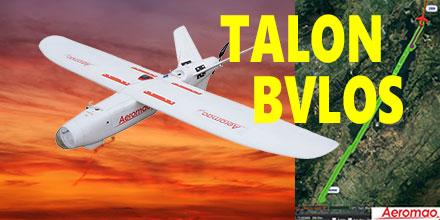 Recently, Aeromao’s Aeromapper Talon successfully completed an autonomous mission to a target located 30km away.
The Talon maintained strong communications and its control link throughout the entire mission.
This mission successfully demonstrated the potential for Beyond Visual Line of Sight (BVLOS) operations for the Talon.
The Aeromapper Talon costs only a fraction compared to systems with similar capabilities.
The Aeromapper team carried out the mission in the Andes Mountains of South America. The location of the flight was situated at 2,800m above sea level. The flight had a cruise altitude of 250m agl. Fifty percent of the flight traversed a body of water. The Talon traveled a total distance of 60km in its one hour flight.
With a flight endurance of 2-hours, the Talon had enough flight time left to travel an additional 30km. However, the operators decided to bring the UAV back due to peaks in excess of 3,500 m above sea level in the flight path.
Currently, the team is planning a future mission to demonstrate 50km reach capabilities.
Aeromao’s Aeromapper 300 also uses the same long range communication system as the Talon.
The demand for BVLOS missions continues to grow throughout the industry. Applications for such missions include: power line and pipeline monitoring, roadways survey, surveillance and wildlife control, as well as long linear missions.
“We receive many requests from clients who need to fly linear missions sometimes to survey thousands of kilometers of pipelines, power lines or roadways,” said Mauricio Ortiz of Aeromao. “We ourselves have completed hundreds of kilometers of linear projects, and know very well the challenges of these types of operations.”
The Aeromapper Talon is proving a solid solution given the specific capabilities demanded for these applications. Aeromapper Talon performs well in all:
Additionally, the Aeromapper Talon is also a multi-mission payload complete solution. It is a great choice for various applications, such as agriculture, centimeter accurate surveys, surveillance, and monitoring. Payloads available include:
Shop Aeromao’s entire line of affordable UAV solutions at Unmanned Systems Source.
