Description
Nothing but water all around?
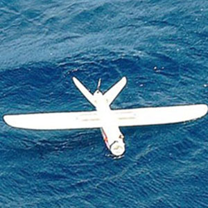
The Aeromapper Talon Amphibious is fully waterproof, externally and internally. Even if filled completely with water internally, it won’t sink, it won’t suffer any damage. Each component is waterproof and modular, minimizing maintenance costs. This redundant approach that guarantees repeatability and dependability.
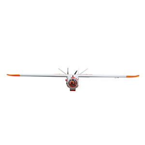
The Amphibious version of the Aeromapper Talon allows maritime operations by autonomously belly landing on water. It’s the perfect solution for aerial observation, data collection and mapping thanks to its dual camera set up and video link range up to 20kms.
System Highlights

The drone allows for easy operation thanks to its autonomous take off upon hand launch, autonomous navigation, and auto land.
Best of all, forget about paying an arm and a leg for a dependable, portable amphibious drone. The Aeromapper Talon Amphibious comes in an affordable package and its components are modular and future-proof.
Its rugged and durable construction allows for repeated use and tough handling and still being very easy to repair in the field.
Capture 20Mp stills or HD video facing down or add the optional forward-looking camera with long range real-time video link of exceptional image quality. The forward-looking camera can be panned from the hand-held remote control to look sideways and lock on points of interest by loitering the UAV around them.
The standard range of the video signal is 15-20 Km but it can be extended to 40km using our 24 dBi parabolic antenna (optional).
The forward-looking camera system comes complete and ready to use, including the heavy-duty Ground Control Station, with 10’’ LCD monitor and diversity receiver.
Best of all, you can still parachute down on dry land when required. The Aeromapper Talon Amphibious version also features our standard long-range capabilities for BVLOS (Beyond Visual Line of Sight operations) (+30Km control and telemetry links).
Standard System Includes
- Aeromapper Talon Amphibious Unmanned System Ready-t0-Fly
- One set of batteries for 2 hours of flight time
- +30 Km Link System
- Sony 20mp Camera
- Hand-held Controller w/ long-range system
- Lipo Battery Charger
- User’s Manual and Documentation
- Heavy duty carrying case
- Mission Planner Software
- 1 Year Limited Warranty

Long-Range FPV System Includes
This system consists of a waterproof camera setup with controllable panning, on-board video transmitter, Ground Control Station with redundant receiver capability, 10″ LCD monitor conveniently integrated into a highly mobile rugged carrying case with swappable rechargeable batteries capable of many hours of operation in the field.
The GCS is designed for fast deployment and redundant link technology to guarantee a strong video signal independently of UAV orientation at long distances.
- Standard video link range: 15-20 Km. Extendable to 40 km with an optional parabolic antenna. Exceptional video link quality.
- Camera records video in HD. Video signal can also be recorded from video receiver while in flight. (external video recorder included)
- All onboard system components are waterproof.
- Camera panning is controllable from a hand-held controller for maximum searching coverage. Keep a constant eye on a point of interest by panning camera sideways and loiter over the target while drone automatically maintains altitude and airspeed.
- The camera system and Ground Control Station is plug-n-play. Includes: 10’’ LCD monitor, diversity receiver, long range antennas, tripod, power setup, and heavy duty waterproof case. Delivers high quality video in real time. Band: 2.4 GHz
- Includes OSD (On Screen Display).

Dependable
Guaranteed craft survival even with water intrusion thanks to a redundant design. Even if it becomes full of water, it won’t sink and internal components suffer no damage. Marine grade craft.


Operations
Operate in offshore, flooded areas, rivers, lakes, from a moving boat – without ever setting foot on land.
Easily hand-launch from any boat and recover easily from the water.
Parachute Landing
Parachute landing can also be used over dry land. The Aeromapper Talon Amphibious is the only UAV in the world that belly lands on water, parachutes down on land, and carries a dual set of cameras for aerial observation and mapping.

About Aeromao
Aeromao is a company with the vision of becoming a worldwide leader in UAV innovation by creating the most versatile, small unmanned vehicles for civil applications. Aeromao is backed by years of experience and a history of innovative endeavors in the area of UAVs for high-precision mapping and aerial photography uses.