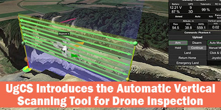
UgCS's new automatic Facade Scan tool for drone inspection mission planning is a time and cost saver for construction, engineering and mining industries.
Tools for surveying horizontal surfaces — even uneven ones — are widely available on the market and have been for some time. However, inspecting vertical surfaces is a completely different story. Previously, vertical surface inspection was a burden for professional drone users because it required a lot of manual work. But, thanks to the automatic Facade Scan tool from UgCS, that burden is no more.
Vertical Scan Tool
The new Facade Scan tool has many applications for construction, architecture and other industries. The tool creates accurate digital models of buildings or cultural heritage objects. Plus, it identifies heat leaks and damage to walls.
Facade Scan allows the drone operator to draw a vertical plane, specify the distance to the wall as well as side and forward overlap. Once complete, it automatically calculates the optimal flying path. UgCS also supports the import of 3D objects and custom DEM data using the terrain-following function.
Mining Applications
The tool makes it possible to examine open quarries for mining applications. These inspections via drone provide cost savings measures and keep humans from dangerous work. Drones can survey even unstable pits from a safe distance; the data gathered is much more accurate compared to other methods that don’t involve workers climbing down the pit. As mines often change due to work and natural conditions, repeated drone inspections bring data up-to-date in a fast and convenient way.
“With its choice of automatic and manual tools, UgCS is extremely versatile and suitable even for the most specific needs,” says one mining professional. “We can use several different drones for the same mission, or a number of different drones with different kinds of sensors. If a drone runs out of battery, there is no need to start a new mission — it can be resumed where it was interrupted. We also appreciate the terrain following mode that allows drones to follow the surface accurately. We use it for both horizontal and vertical surveys.”
Facade scan is part of the UgCS 3.2 release. It joins the family of other automatic UgCS tools: the Photogrammetry tool, Search Pattern tool and Area scan. It is available under a lifetime license, or a subscription based license of 1 and 3 months. UgCS supports most DJI drones, as well as MAVLink compatible and other UAVs. SPH Engineering continues to support and update the Facade Scan tool and welcomes comments from professional drone users across all industries.
Find out more about UgCS Mission Planning Software at Unmanned Systems Source.
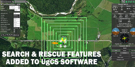
UgCS, provider of mission planning software for unmanned aircraft systems (UAS), together with public safety and disaster response UAS experts Airborne Response, developed a comprehensive search capability for drones.
The new feature allows remote pilots to more effectively conduct search and rescue operations using the UgCS platform.
Software Enhancements
The new enhancements provides users with a variety of quickly customizable search patterns. Such patterns include the “expanding square” and “creeping line” which can easily deploy in emergency and non-emergency situations.
Based on the flight altitude input by the operator, the UgCSsoftware automatically calculates key variables. These variable include, the course heading and track spacing necessary to provide the prescribed coverage area for a search target.
“The new enhancements to the UgCS mission planning software allow remote pilots, at every skill level, to quickly plan and implement a professional search mission with a UAS,” said Tom “Oaty” Oatmeyer, Chief Pilot at Airborne Response.
Expert Lends Expertise
Oatmeyer is an air rescue expert with 28 years of experience piloting helicopters for both the U.S. Air Force and the Miami-Dade Fire Rescue department.
Oatmeyer worked directly with the UgCS development team to bring the new features to fruition.
“The new UgCS search feature is designed to make searching for a target with a drone as simple and reliable as possible,” said Janis Kuze, Sales Director of SPH Engineering. “We look forward to our continued work with Airborne Response to further enhance capabilities and implement additional features.”
Airborne Response and UgCS reached an agreement for Airborne Response to offer the UgCS mission planning software, and associated training, to public safety and emergency response professionals throughout the U.S.
“When lives are on the line, every second counts,” asserts Oatmeyer.“UgCS now represents another valuable link in the UAS technology chain to enhance the public safety mission.”
SPH Engineering announces the launch of UgCS centralized drone management solution for Police, Search and Rescue, Firefighter and Security Service Command centers for efficient drone implementation in first response and surveillance operations.
This centralized solution was presented at MiliPol 2017.
How it works
UgCS centralized drone management solution enables Command center operators to track the real-time position of drones in-field. Plus, receive live video streams. Command center operators can also mark points of interest on the shared map. Thus, alerting field drone operators to conduct detailed inspections of certain areas. Centralized management centers can even take manual control over the drone and its camera.
UgCS is built to ensure full integration into enterprise infrastructure. Additionally, UgCS centralized drone management solution can integrate with existing Command center software.
To enable complete data security, all UgCS components can deploy in a private network to transfer data over a secure connection (no internet required). Also, command centers can access acquired or stored data for detailed incident investigation or to analyze equipment’s usage and plan maintenance.
Effective management for first responders
“UgCS centralized drone management solution enables effective UAV integration into emergency and security command centers. UgCS and drones provides a live preview of the situation not only to personnel in-field, but for officers at Command center. This enables more precise situation assessment, decision making and effective management of first responder teams, providing more efficient resolution of disaster situation or even saving lives,” said Janis Kuze, SPH Engineering sales director. “A capital city police department is currently using this solution.”
Additionally, UgCS enables support for the most popular UAV models. Also, the UgCS centralized drone management solution has no vendor lock. It supports DJI, Yuneec, Lockheed Martin and MAVLink compatible drones (Pixhawk/APM).
Shop UgCS line of solutions at Unmanned Systems Source.
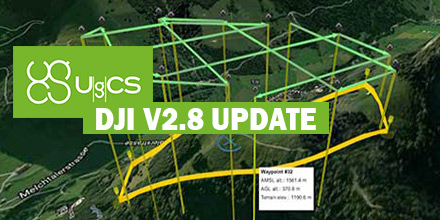
SPH Engineering released updates for both UgCS and the mobile companion, UgCS for DJI.
The update enhances the overall end-user experience as well as features for professional UAV survey mission planning.
Enhanced features
In order to acquire more precise aerial data, a double grid option is now available for Area scan and Photogrammetry tool. When a new Photogrammetry area is added to the survey mission, the action Camera by time (with auto flag) is added by default.
Many mission planning features now offer a more friendly end-user experience. Enhancements include: the option to move and rotate route, manage common actions for selected segments and display calculated path leg length on cursor-hover. Additionally, polygon side length and calculated area size are now displayed.
“Data import, flight planning and control are features that characterize UgCS. Adding the desktop geo-referenced image processing software, UgCS Mapper, to our portfolio provides a nearly complete ground control and mapping platform for UAV professionals," said Janis Kuze, Sales Director at SPH Engineering. "For our customers UgCS Mapper provides significant insight to acquired data quality on site. This will save time and ensure better result. It's truly a PRO solution for PRO’s.”
Added upgrades
Furthermore, SPH Engineering announced the release of the UgCS Mapper (beta). UgCS Mapper is a geo-referenced image processing software for the desktop. It creates preliminary ortho-photo map in-field, requiring no internet connection.
While in beta UgCS Mapper is available for all users, after official release it will be a part of the UgCS PRO and UgCS ENTERPRISE packages.
Additional Ardupilot features include: the option to connect over UDP, an added command and action SET_SERVO and REPEAT_SERVO. Plus, the ability to set constant heading (disable yaw to next waypoint).
Some of the new UgCS for DJI features, include: drones with multiple video feed option to select video source added, zoom control widget improved and a notification is displayed when a waypoint is reached and left.
Update links
Download the latest version of UgCS v2.12 and UgCS for DJI v2.8 below.
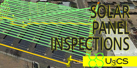
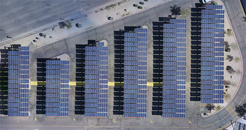
Solar panel fields, like any other artificial infrastructure objects, require periodical inspections. Usually photovoltaic (PV) solar panel field inspection requires use of two sensors - infrared (IR) and daylight cameras, to detect faulty panels. Solar panels may heat up because of connection issues, physical damage or debris.
A drone equipped with a thermal camera is the best choice for solar panel field inspection. This method saves costs compared to manned aviation and saves time compared to visual control with handheld IR camera.
Semi-professional drones with changeable cameras like DJI Inspireare an option. However, switching out cameras means flight time is doubled. The first is a survey flight conducted with a daylight camera. The flight is then repeated after changing to an IR camera. To minimize time required for inspection usually both sensors (cameras) are used simultaneously. Such a payload requires a drone with enough lift-off capability.
Detectable defects
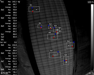
The two major defects visible with IR camera are connection issues and physical damage.
Connection issues occur, for example, when a panel or a string of panels are not connected to the system. As a result, power produced from the panel(s) cannot flow through the system and on to the grid. That power is converted to heat and the entire panel(s) will heat up slightly.
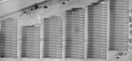
Figure 1
For example, (see Figure 1) the panel marked Bx7 presents little bit higher average temperature comparing to other panels and should be checked for both - defects and connection issues.
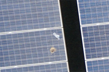
Another detectable defect is physical damage to the underlying panel. This causes small areas of more extreme heating as power flows around and backs up behind the damaged area.
Such defects are visible on sample - bright point in rectangle marked Bx3 with maximum temperature 169.4 F (76.3 C). Also, physical damages are visible in other zones.
Both kind of defects usually are clearly visible on images in IR spectrum what makes defects localisation relatively easy even on stitched orthophoto.
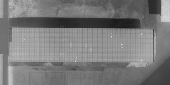
Figure 2
In visible spectrum, (using daylight camera) usually only debris on panels is detected. This information, though, helps determine if the hotspot is the actual panel heating up or if it is the debris (dirt, bird droppings, etc) heating up.
Figure 3
Glass breaks are usually not detectable unless drone will fly very low as the cracks are small. Only in case of severe damage situations glass breaks will be visible on photos.
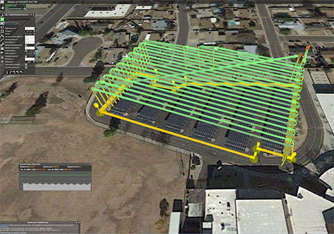
Solar Panel Field Inspection Mission Planning in UgCS
In general, solar panel field inspection missions with drones are planned the same way as standard UAV photogrammetry missions. The survey area is set and the route and camera settings are optimized to obtain the best result for data processing.
Figure 4
GSD selection
For photogrammetry, mission ground sampling distance (GSD) is defined by client and it is the main characteristic of survey’s output data.
In case of solar panel inspection client has to define which defects have to be detected. To detect panels with connection issues GSD for IR images should be set 25 cm. To detect physical damage or hotspots smaller than whole panel the GSD should be set from 5-16 cm.
For survey missions, when a drone carries IR and daylight cameras simultaneously, the GSD for daylight camera isn’t relevant. This is because it produces pictures with much better GSD than IR sensor because of the low resolution of thermal cameras. For example, an optical camera with a 16 mm lens to match the 7.5 mm FLIR lens will produce images with 1.3GSD while the FLIR images are at 15.7GSD.
For solar panel survey missions, when a drone with changeable cameras is used set GSD > 2 cm - this will enable to detect even small debris on panels but will not produce thousands of images from flight.
Camera position
Mostly camera are set to nadir position. In situations where a tracker system can't be positioned at a set angle or for some fixed array sites – based on the time of the day and sun position oblique setup can be used.
Optimal angle of solar panels for thermal images is from 5 to 30 degrees to avoid reflection and inaccurate temperatures. If such images can’t be acquired with nadir camera position, the camera angle has to be adjusted to ensure pictures of panels in range from 5 to 30 degree angle.
Data processing
Standard image data processing techniques can be used to stitch photos taken with daylight and IR cameras.
Figure 5
Orthophoto maps of relatively small solar panel fields can be analysed manually with different zoom level. To enable rapid evaluation for large fields with millions of panels automated defect detection should be used. Defected panels are marked and further inspections can be accomplished manually.
Figure 6
Without doubt the use of UAV for area surveying or infrastructure inspection saves on both time and cost. Drone mission planning features and tools of UgCS enable UAV professionals to customize each mission according to application requirements.
Find the right UgCS Mission Planner Software that is right for you at Unmanned Systems Source.
Article is written in collaboration with Industrial Aerobotics, Arizona-based company providing aerial inspection, surveying and mapping services using UAVs and reprinted with permission.
March 23, 2017 – Unmanned Systems Source is pleased to announce a new distribution agreement with SPH Engineering.
SPH Engineering is the creator of the popular UgCS Mission Planning Software which provides central management of all types and manufacturers of UAVs. It supports both fixed wing and multi-rotor platforms.
Supported platforms, include: DJI Phantom 4 / 4 Pro, Phantom 3 and Phantom 2, Inspire 2, Inspire 1 / 1 Pro / Raw, Mavic Pro, A3, N3, Matrice 600 / 600 Pro, Matrice 100, A2, Naza-M v2, WooKong-M, Vision2+, Ace One.
Currently, supported autopilots, include: Ardupilot, Px4 and other MAVLink compatible; InnoFlight: Jupiter JM-1; Mikrokopter; Micropilot; Microdrones; LockheedMartin: Kestrel, Indago.
"UgCS software is a great addition to our site," said Andrew Osbrink, Business Development Director at Unmanned. "Whether a customer operates a fixed wing or multi-rotor, many crafts or just one, UgCS' flexible licensing model means organizations can purchase the license that works for their situation."
The UgCS Desktop Solution
UgCS software has convenient tools for areal and linear surveys and provides direct drone control. Its modular architecture means ease of integration and simplifies adding support for new vehicles or payloads. Other features include easy route creation, an immersive 3D mission planning environmental and No-Fly zone support. In addition, it has built-in photogrammetry and geotagging tools, map customization, and more.
Users can control one or a fleet of drones on a single mission, in multi-operator mode and in multi-platform environments.
UgCS Mission Planning software options
OPEN is the free version of UgCS software. It offers limited capabilities in terms of the range of operations, functionality and support. However, it allows users insight into the software before making a purchasing decision.
For UAV hobbyists and non-professional users, the ONE license is recommended. It provides unlimited range of operations with some limitation of the advanced functions.
The PRO license is recommended for UAV professionals and land surveyors. It is the fully functional, multi-drone ground control software for professional UAV mission planning. Includes photogrammetry tools, digital elevation model (DEM) and KML file import to enable map customization. It also offers ADS-B receiver support to ensure flight safety.
And finally, the ENTERPRISE license is for companies that operate a fleet of different manufacturer drones requiring a unifying ground station solution. Features ADS-B transponder support, multi-node deployment enables operation of a central server with unlimited connection to UgCS universal control server.
About SPH Engineering
Founded in 2013, SPH Engineering employs both professionals and enthusiasts. They turn client ideas into products that address specific needs and requirements. Technology is not just a product for SPH Engineering, it's their passion.
Visit Unmanned Systems Source to shop and compare UgCS Mission Planning license plans to find the one that is right for you.

 UgCS's new automatic Facade Scan tool for drone inspection mission planning is a time and cost saver for construction, engineering and mining industries.
Tools for surveying horizontal surfaces — even uneven ones — are widely available on the market and have been for some time. However, inspecting vertical surfaces is a completely different story. Previously, vertical surface inspection was a burden for professional drone users because it required a lot of manual work. But, thanks to the automatic Facade Scan tool from UgCS, that burden is no more.
UgCS's new automatic Facade Scan tool for drone inspection mission planning is a time and cost saver for construction, engineering and mining industries.
Tools for surveying horizontal surfaces — even uneven ones — are widely available on the market and have been for some time. However, inspecting vertical surfaces is a completely different story. Previously, vertical surface inspection was a burden for professional drone users because it required a lot of manual work. But, thanks to the automatic Facade Scan tool from UgCS, that burden is no more.
 UgCS, provider of mission planning software for unmanned aircraft systems (UAS), together with public safety and disaster response UAS experts Airborne Response, developed a comprehensive search capability for drones.
The new feature allows remote pilots to more effectively conduct search and rescue operations using the UgCS platform.
UgCS, provider of mission planning software for unmanned aircraft systems (UAS), together with public safety and disaster response UAS experts Airborne Response, developed a comprehensive search capability for drones.
The new feature allows remote pilots to more effectively conduct search and rescue operations using the UgCS platform.
 SPH Engineering announces the launch of UgCS centralized drone management solution for Police, Search and Rescue, Firefighter and Security Service Command centers for efficient drone implementation in first response and surveillance operations.
This centralized solution was presented at MiliPol 2017.
SPH Engineering announces the launch of UgCS centralized drone management solution for Police, Search and Rescue, Firefighter and Security Service Command centers for efficient drone implementation in first response and surveillance operations.
This centralized solution was presented at MiliPol 2017.
 Solar panel fields, like any other artificial infrastructure objects, require periodical inspections. Usually photovoltaic (PV) solar panel field inspection requires use of two sensors - infrared (IR) and daylight cameras, to detect faulty panels. Solar panels may heat up because of connection issues, physical damage or debris.
A drone equipped with a thermal camera is the best choice for solar panel field inspection. This method saves costs compared to manned aviation and saves time compared to visual control with handheld IR camera.
Semi-professional drones with changeable cameras like DJI Inspire are an option. However, switching out cameras means flight time is doubled. The first is a survey flight conducted with a daylight camera. The flight is then repeated after changing to an IR camera. To minimize time required for inspection usually both sensors (cameras) are used simultaneously. Such a payload requires a drone with enough lift-off capability.
Solar panel fields, like any other artificial infrastructure objects, require periodical inspections. Usually photovoltaic (PV) solar panel field inspection requires use of two sensors - infrared (IR) and daylight cameras, to detect faulty panels. Solar panels may heat up because of connection issues, physical damage or debris.
A drone equipped with a thermal camera is the best choice for solar panel field inspection. This method saves costs compared to manned aviation and saves time compared to visual control with handheld IR camera.
Semi-professional drones with changeable cameras like DJI Inspire are an option. However, switching out cameras means flight time is doubled. The first is a survey flight conducted with a daylight camera. The flight is then repeated after changing to an IR camera. To minimize time required for inspection usually both sensors (cameras) are used simultaneously. Such a payload requires a drone with enough lift-off capability.
 March 23, 2017 – Unmanned Systems Source is pleased to announce a new distribution agreement with SPH Engineering.
SPH Engineering is the creator of the popular UgCS Mission Planning Software which provides central management of all types and manufacturers of UAVs. It supports both fixed wing and multi-rotor platforms.
Supported platforms, include: DJI Phantom 4 / 4 Pro, Phantom 3 and Phantom 2, Inspire 2, Inspire 1 / 1 Pro / Raw, Mavic Pro, A3, N3, Matrice 600 / 600 Pro, Matrice 100, A2, Naza-M v2, WooKong-M, Vision2+, Ace One.
Currently, supported autopilots, include: Ardupilot, Px4 and other MAVLink compatible; InnoFlight: Jupiter JM-1; Mikrokopter; Micropilot; Microdrones; LockheedMartin: Kestrel, Indago.
"UgCS software is a great addition to our site," said Andrew Osbrink, Business Development Director at Unmanned. "Whether a customer operates a fixed wing or multi-rotor, many crafts or just one, UgCS' flexible licensing model means organizations can purchase the license that works for their situation."
March 23, 2017 – Unmanned Systems Source is pleased to announce a new distribution agreement with SPH Engineering.
SPH Engineering is the creator of the popular UgCS Mission Planning Software which provides central management of all types and manufacturers of UAVs. It supports both fixed wing and multi-rotor platforms.
Supported platforms, include: DJI Phantom 4 / 4 Pro, Phantom 3 and Phantom 2, Inspire 2, Inspire 1 / 1 Pro / Raw, Mavic Pro, A3, N3, Matrice 600 / 600 Pro, Matrice 100, A2, Naza-M v2, WooKong-M, Vision2+, Ace One.
Currently, supported autopilots, include: Ardupilot, Px4 and other MAVLink compatible; InnoFlight: Jupiter JM-1; Mikrokopter; Micropilot; Microdrones; LockheedMartin: Kestrel, Indago.
"UgCS software is a great addition to our site," said Andrew Osbrink, Business Development Director at Unmanned. "Whether a customer operates a fixed wing or multi-rotor, many crafts or just one, UgCS' flexible licensing model means organizations can purchase the license that works for their situation."