SPH Engineering Releases Updates for UgCS v2.12 and UgCS for DJI v2.8
SPH Engineering released updates for both UgCS and the mobile companion, UgCS for DJI.
The update enhances the overall end-user experience as well as features for professional UAV survey mission planning.
Enhanced features
In order to acquire more precise aerial data, a double grid option is now available for Area scan and Photogrammetry tool. When a new Photogrammetry area is added to the survey mission, the action Camera by time (with auto flag) is added by default.
Many mission planning features now offer a more friendly end-user experience. Enhancements include: the option to move and rotate route, manage common actions for selected segments and display calculated path leg length on cursor-hover. Additionally, polygon side length and calculated area size are now displayed.
“Data import, flight planning and control are features that characterize UgCS. Adding the desktop geo-referenced image processing software, UgCS Mapper, to our portfolio provides a nearly complete ground control and mapping platform for UAV professionals,” said Janis Kuze, Sales Director at SPH Engineering. “For our customers UgCS Mapper provides significant insight to acquired data quality on site. This will save time and ensure better result. It’s truly a PRO solution for PRO’s.”
Added upgrades
Furthermore, SPH Engineering announced the release of the UgCS Mapper (beta). UgCS Mapper is a geo-referenced image processing software for the desktop. It creates preliminary ortho-photo map in-field, requiring no internet connection.
While in beta UgCS Mapper is available for all users, after official release it will be a part of the UgCS PRO and UgCS ENTERPRISE packages.
Additional Ardupilot features include: the option to connect over UDP, an added command and action SET_SERVO and REPEAT_SERVO. Plus, the ability to set constant heading (disable yaw to next waypoint).
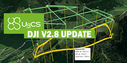
Some of the new UgCS for DJI features, include: drones with multiple video feed option to select video source added, zoom control widget improved and a notification is displayed when a waypoint is reached and left.
Update links
Download the latest version of UgCS v2.12 and UgCS for DJI v2.8 below.
- UgCS version: www.ugcs.com/download
- Download latest UgCS for DJI version: www.ugcs.com/download_app_for_dji
Shop UgCS line of software packages at Unmanned Systems Source.