
BVLOS Demo Over Mobile Network
For the first time in the Baltic region, BVLOS conducted entirely on the mobile network
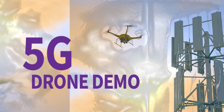
RIGA, LATVIA (EINPresswire.com) – Recently, 5G Techritory, the Baltic Sea Region 5G Ecosystem Forum, opened with a unique demonstration.
For the first time in the region, a BVLOS drone flight took place entirely via mobile network.
Throughout the demonstration, the drone seamlessly switched from one base station to another.
BVLOS Demo Over Mobile Network
The drone flight took place within the Adazi airport territory, 25 km away from the conference location.
Latvian Mobile Telephone (LMT) President Juris Binde and Prime Minister of the Republic of Latvia, Krišjānis Kariņš controlled the drone remotely.
Throughout the flight, LMT tested the strength of the mobile network.
The results showed that the network strength met 97.6% of the requirements for successful remote drone management.
“One of the most important issues was how to make 5G “fly” metaphorically speaking. It’s not a matter of building a network, that's the easy part,” said Binde. “What is not clear, however, is how to use this network for the needs and purposes of increasing competitiveness, productivity, for business and society.”
BVLOS Demo Over Mobile Network
The industrial use of drone flights via mobile networks are varied.
A prime beneficiary of such technology is any infrastructure which requires frequent monitoring. This includes infrastructure, such as: gas and oil pipelines, power supply lines, seaports.
It is significantly cheaper and more effective to conduct these flights via mobile networks. Such inspections are possible with preset drone flights.
“When we decided to demonstrate a live flight approximately 20 km from here, many said we were crazy or brave,” said Binde. “To show something live is very risky. However, we are used to risk, because our mobile networks are live all the time.”
In order to ensure that the use cases are secure on a mobile network, the network must be tested for higher altitude data usage.
Repeatedly, LMT has demonstrated a strong mobile network. However, the challenge involved proving the network's strength above ground level.
The demonstration showed that safe, remote-controlled drone flights are possible.
In addition, LMT tested a tool which provides a prognosis of network coverage in the air.
The tool was a result of a collaboration with Austrian software developer, Dimetor. The tool provides an additional safety measure through drone flight path planning.
In support of the demonstration, SPH Engineering developed a pre-programmed and automated drone flight path.
SPH Engineering, also a Latvian company, developed the popular UgCS Mission Control Software.
The team tested the drone flight at various heights – ground level, 50m, and 120m in the air.
Demo Takeaways
There were several key takeaways as a result of the the demonstration.
For one, it reinforces the need to develop the infrastructure and laws necessary to make BVLOS drone flight a reality.
It also showed the safe and predictable flight of remote-controlled drones on automated flight paths.
The demonstration helps lay the foundation for additional research and expansion of use cases – first in industrial areas and, later, in smart city applications.
Future Possibilities
There is growing interest in autonomous BVLOS drone flight.
For example, LMT is collaborating with the Latvian State Forests, which must continually monitor their forests. To do so via drone means practically each flight path would be BVLOS.
Latvian State Forest has a variety of responsibilities, including: monitoring forest growth, illegal deforestation and looking out for wildfires. Additionally, they also monitor areas experiencing bark beetle infestations. In recent years, this infestation has led to significant losses in Europe’s forests.
LMT is no stranger to testing non-terrestrial mobile networks. In July of 2019, they set a record for the highest noted mobile network coverage, at 85,000 feet in the air (26 km).
As the strength of mobile networks increases, the applications are sure to follow suit.
Find out more and purchase UgCS Mission Planning Software at Unmanned Systems Source.
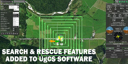 UgCS, provider of mission planning software for unmanned aircraft systems (UAS), together with public safety and disaster response UAS experts Airborne Response, developed a comprehensive search capability for drones.
The new feature allows remote pilots to more effectively conduct search and rescue operations using the UgCS platform.
UgCS, provider of mission planning software for unmanned aircraft systems (UAS), together with public safety and disaster response UAS experts Airborne Response, developed a comprehensive search capability for drones.
The new feature allows remote pilots to more effectively conduct search and rescue operations using the UgCS platform.
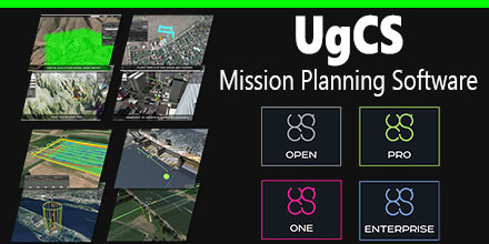 March 23, 2017 – Unmanned Systems Source is pleased to announce a new distribution agreement with SPH Engineering.
SPH Engineering is the creator of the popular UgCS Mission Planning Software which provides central management of all types and manufacturers of UAVs. It supports both fixed wing and multi-rotor platforms.
Supported platforms, include: DJI Phantom 4 / 4 Pro, Phantom 3 and Phantom 2, Inspire 2, Inspire 1 / 1 Pro / Raw, Mavic Pro, A3, N3, Matrice 600 / 600 Pro, Matrice 100, A2, Naza-M v2, WooKong-M, Vision2+, Ace One.
Currently, supported autopilots, include: Ardupilot, Px4 and other MAVLink compatible; InnoFlight: Jupiter JM-1; Mikrokopter; Micropilot; Microdrones; LockheedMartin: Kestrel, Indago.
"UgCS software is a great addition to our site," said Andrew Osbrink, Business Development Director at Unmanned. "Whether a customer operates a fixed wing or multi-rotor, many crafts or just one, UgCS' flexible licensing model means organizations can purchase the license that works for their situation."
March 23, 2017 – Unmanned Systems Source is pleased to announce a new distribution agreement with SPH Engineering.
SPH Engineering is the creator of the popular UgCS Mission Planning Software which provides central management of all types and manufacturers of UAVs. It supports both fixed wing and multi-rotor platforms.
Supported platforms, include: DJI Phantom 4 / 4 Pro, Phantom 3 and Phantom 2, Inspire 2, Inspire 1 / 1 Pro / Raw, Mavic Pro, A3, N3, Matrice 600 / 600 Pro, Matrice 100, A2, Naza-M v2, WooKong-M, Vision2+, Ace One.
Currently, supported autopilots, include: Ardupilot, Px4 and other MAVLink compatible; InnoFlight: Jupiter JM-1; Mikrokopter; Micropilot; Microdrones; LockheedMartin: Kestrel, Indago.
"UgCS software is a great addition to our site," said Andrew Osbrink, Business Development Director at Unmanned. "Whether a customer operates a fixed wing or multi-rotor, many crafts or just one, UgCS' flexible licensing model means organizations can purchase the license that works for their situation."