Tag - software

UgCS Introduces the Automatic Vertical Scanning Tool for Drone Inspection Mission Planning

UgCS's new automatic Facade Scan tool for drone inspection mission planning is a time and cost saver for construction, engineering and mining industries. Tools for surveying horizontal surfaces — even uneven ones — are widely available on the market and have been for some time. However, inspecting vertical surfaces is a completely different story.  Previously, vertical surface inspection was a burden for professional drone users because it required a lot of manual work. But, thanks to the automatic Facade Scan tool from UgCS, that burden is no more.  
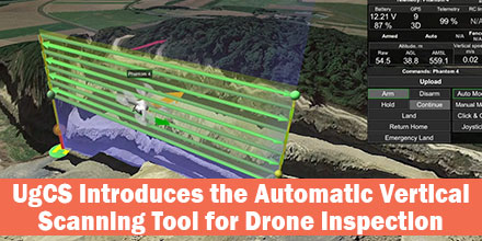
Vertical Scan Tool

The new Facade Scan tool has many applications for construction, architecture and other industries. The tool creates accurate digital models of buildings or cultural heritage objects. Plus, it identifies heat leaks and damage to walls. Facade Scan allows the drone operator to draw a vertical plane, specify the distance to the wall as well as side and forward overlap. Once complete, it automatically calculates the optimal flying path. UgCS also supports the import of 3D objects and custom DEM data using the terrain-following function.  

Mining Applications

The tool makes it possible to examine open quarries for mining applications. These inspections via drone provide cost savings measures and keep humans from dangerous work.  Drones can survey even unstable pits from a safe distance; the data gathered is much more accurate compared to other methods that don’t involve workers climbing down the pit. As mines often change due to work and natural conditions, repeated drone inspections bring data up-to-date in a fast and convenient way. “With its choice of automatic and manual tools, UgCS is extremely versatile and suitable even for the most specific needs,” says one mining professional. “We can use several different drones for the same mission, or a number of different drones with different kinds of sensors. If a drone runs out of battery, there is no need to start a new mission — it can be resumed where it was interrupted. We also appreciate the terrain following mode that allows drones to follow the surface accurately. We use it for both horizontal and vertical surveys.” Facade scan is part of the UgCS 3.2 release. It joins the family of other automatic UgCS tools: the Photogrammetry tool, Search Pattern tool and Area scan. It is available under a lifetime license, or a subscription based license of 1 and 3 months. UgCS supports most DJI drones, as well as MAVLink compatible and other UAVs. SPH Engineering continues to support and update the Facade Scan tool and welcomes comments from professional drone users across all industries.   Find out more about UgCS Mission Planning Software at Unmanned Systems Source.

UgCS Releases Centralized Drone Management Solution for Command Centers

SPH Engineering announces the launch of UgCS centralized drone management solution for Police, Search and Rescue, Firefighter and Security Service Command centers for efficient drone implementation in first response and surveillance operations. This centralized solution was presented at MiliPol 2017.  

How it works

UgCS centralized drone management solution enables Command center operators to track the real-time position of drones in-field. Plus, receive live video streams. Command center operators can also mark points of interest on the shared map. Thus, alerting field drone operators to conduct detailed inspections of certain areas. Centralized management centers can even take manual control over the drone and its camera. UgCS is built to ensure full integration into enterprise infrastructure. Additionally, UgCS centralized drone management solution can integrate with existing Command center software. To enable complete data security, all UgCS components can deploy in a private network to transfer data over a secure connection (no internet required). Also, command centers can access acquired or stored data for detailed incident investigation or to analyze equipment’s usage and plan maintenance.  

Effective management for first responders

“UgCS centralized drone management solution enables effective UAV integration into emergency and security command centers. UgCS and drones provides a live preview of the situation not only to personnel in-field, but for officers at Command center. This enables more precise situation assessment, decision making and effective management of first responder teams, providing more efficient resolution of disaster situation or even saving lives,” said Janis Kuze, SPH Engineering sales director. “A capital city police department is currently using this solution.” Additionally, UgCS enables support for the most popular UAV models. Also, the UgCS centralized drone management solution has no vendor lock. It supports DJI, Yuneec, Lockheed Martin and MAVLink compatible drones (Pixhawk/APM).   Shop UgCS line of solutions at Unmanned Systems Source.

Phase One Industrial brings their aerial cameras to Unmanned Systems Source

Phase One joins Unmanned Systems Source November 17, 2014 – Unmanned Systems Source’s offering of aerial cameras has expanded thanks to a new distribution partnership with Phase One Industrial. Phase One Industrial provides advanced hardware and imaging software solutions for both manned and unmanned systems. A division of Phase One A/S, Phase One Industrial is dedicated to the research, development and manufacturing of specialized industrial camera systems and software. The company's camera systems are built specifically for aerial photography. “It’s exciting to see a company like Phase One Industrial make inroads into the unmanned world,” said Jennifer Jerrick, President of Unmanned Systems Source. “Phase One iXU 150 aerial cameras are full-featured medium format aerial cameras that are reliable and versatile. It also boasts a 50 MP CMOS sensor – which certainly put a smile on the face of our engineers when they saw it.” Milled from magnesium, the iXU 150 is 30% lighter than an aluminum design. Its light weight and small footprint make it perfectly suited for UAV integration, mapping and multiple camera configurations. They are also easily integrated into existing or new setups and offer maximum connectivity with systems for a host of unmanned and manned applications. Visit www.unmannedsystemssource.com to shop the Phase One Industrial product line today.
About Unmanned Systems Source
Headquartered in Tucson, Arizona, Unmanned Systems Source is an online, e-commerce warehouse with the fastest growing selection of unmanned systems and remote sensing products available today.  It is positioned as a single source of supply and information with innovative configuration and development tools that enable visitors to research, configure and purchase fully customized unmanned system to suit specific applications…all with the click of a mouse.  Unmanned Systems Source serves commercial, governmental and public sectors.