
Successful BVLOS missions conducted by Aeromapper Talons
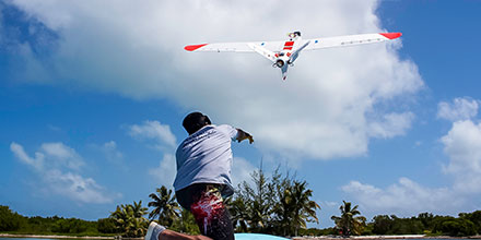
Recently, two units of amphibian Aeromapper Talons successfully conducted trials in beautiful Turneffe Atoll in Belize. The Zoological Society of London and the Turneffe Atoll Sustainability Association led the work.
The Turneffe Marine Protected Area (MPA) in Belieze was delineated in 2012. However, managing the MPA and protecting it from illegal fishing has proven difficult given its size and remote location. All of which contributed to high running costs.
Soaring costs
The current enforcement strategy on the Turneffe atoll involves patrols in small boats searching for illegal fishers. Unfortunately, systematic surveys for megafauna — such as turtles, dolphins and sharks — do not occur regularly. Instead, the conservation officers tend to document animals they happen across on their patrol.
Due to costs, patrols only cover a limited amount of territory. The drones proved to a be an exceptional low-cost solution to these challenges.
Given the application, environment and desire to cut costs, the Aeromao’s Talon Amphibious drone seemed a perfect solution. Capable of water-landing, the water-proof, long-range, fixed-wings came equipped with multi-cameras.
The mission involved monitoring and surveying marine megafuana, gathering evidence of illegal, unreported and unregulated fishing (IUU). Plus, conducting ecology research toward conservation efforts.
”The amphibious drone was able to fly to the site of interest at 110m altitude, gather intelligence and fly back very quickly. The images highlighted that indeed illegal building work had been occurring. Without the UAV the conservation officers would have no way of knowing this and they were very excited at this revelation”, states one of the conservation officers.
The conservation team found the front live-link HD camera an exceptional revelation. In one instance, it allowed them to spot a diving boat on the LCD screen — something the team could barely see from land. The UAV can fly up to 90-minutes. That, in addition to flying at 62kph, means it travels considerable distance and area for surveillance.
BVLOS Operation
Additionally, the pair of drones repeatedly operated in Beyond Visual Line of Sight (BVLOS) scenarios. In total, the team conducted 24 sucessful BVLOS flights during the trials. The average length of 10.9km and with total transect lengths of 263km.
The UAV reached a furthest point BVLOS of 11.3km. In a particular scenario, conservation officers wanted to scope out a development site several kilometers away. The team hoped to use the drones BVLOS capabilities to detect any infringement of their building contract.
The Talon amphibious drone was able to fly to the site of interest at 110m altitude, gather intelligence and fly back very quickly. The images and video showed that, indeed, illegal building work was occurring. Without the UAV the conservation officers would have no way of knowing this; they were very excited at this revelation.
“We now have the tool we need to see further and faster than before. No one will see us coming!” said Maurice, a conservation officer.
During flight, the 20mp nadir camera either captured 5 images per second, or stunning HD film. The front camera, which panned left to right, filmed and recorded a live stream. This allowed the conservation officers to monitor what was happening in real time.
Although the drones normally fly on pre-designed routes in auto mode, switching to “assisted mode” allows operators the flexibility to investigate something of interest.
For instance, if fishers are in an off-limits zone, operators can quickly re-route the drones. Operators can get additional pictures, loiter and provide continuous surveillance around the point of interest.
If images capture dolphins, the team can redirect the drones, capture additional pictures and use the images to estimate area population. Mapping of habitats, using the nadir camera was also possible. Some areas of coral reef and seagrass beds were mapped using Agisoft Metashape.
Static-launch capability
Several static launches of the UAV from a small, moving skiff were also successfully performed. Such launches are unheard of for a fixed wing – long range amphibious unmanned aircraft. This is a tremendously important, and previously unknown ability of the UAV.
This capability allows conservation officers to steam to an area even when a beach for launching may not exist. Instead, operators can simply launch from the boat. Once the mission is over, the drone simply lands on the water besides the skiff for retrieval.
Mission success
During the surveys, the drones gathered impressive geo-referenced images of turtles, sharks, eagle rays, manatees, and birds. These images helped identify environmental issues such as plastic debris and sargassum seaweed which causes deoxygenation of the water and blocks out sunlight.
Using the data, the team built spatial pictures of how both fishers and fauna use the atoll. This information helps ecologists identify marine protected zones.
The scientists leading the expedition stated that having a UAV which can safely land on the ocean and quickly re-deploy in moments, is an exceptionally valuable tool.
Conservation officers in the Turneffe Atoll are adamant that a UAV like the ones trialed, will become an essential part of the patrol and enforcement strategy.
Read full report Case Study and Technical Report here: https://www.aeromao.com/2019/08/02/aeromapper-talon-amphibious-routinely-fly-bvlos-missions-over-marine-reserve-for-illegal-fishing-detection-and-biodiversity-research/
Shop the entire line of Aeromao’s fixed-wing solutions at Unmanned Systems Source.