News

How drones are turning the tide on coastal monitoring

New and emerging technologies tend to enhance existing industries and services. In addition, emerging technologies also help create new industries and services. Unmanned aerial vehicles are one of the biggest trends due in part to their potential use across a range of service and industry applications. One such emerging application is coastline monitoring.  

Drones help fight the tide

There are many reasons why coastlines are under threat but climate change is widely seen as one of the biggest causes of beach erosion. A number of companies are starting to use drone technology for many coastal monitoring applications. The issue of protecting coastlines is a critical one in many countries across the globe. In the UK alone, over a million residential and commercial properties, as well as thousands of hectares in agricultural land lie within areas that are at the mercy of unpredictable changes. Undertaking coastal protection studies requires careful monitoring of any changes that occur. The most efficient solutions for arresting and reversing erosion of coastlines also requires an understanding of existing environmental factors and their effect on the affected beaches. Monitoring thousands of miles of coastline, though, is a tough ask especially in an era of dwindling financial resources. Effective solutions are gleaned through careful consideration of the above factors combined with any available historical knowledge and data. In effect, this is where emerging technologies like unmanned aerial vehicles come in.  

Coastal monitoring drones

Drones are quickly becoming an invaluable tool to both monitor and help maintain the health of coastlines around the world. UAVs provide many advantages for this application. One such advantage is a drone's ability to cover increasingly large distances in a single flight. Plus, when outfitted with the right equipment, drones can capture highly detailed images and footage. The data harvested on these mission can, in turn, help inform decision making. An additional advantage of using UAVs for coastline monitoring is the elimination of any human risk. For example, drones can quickly conduct an initial survey to assess damage after large storm events. UAVs can also monitor potentially dangerous situations, such as the stability of cliffs, from a safe distance. Additionally, UAVs can keep track of beach erosion by measuring land volume and capture changes in coastal vegetation states.  

Matching the drone to the environment

One company, QuestUAV, is demonstrating how new technologies can help tackle serious issues like environmental degradation. Their coastal monitoring work has helped local communities slowly reclaim lost beaches and coastlines. The harsh environment of the North Sea seemed a fitting place to test the feasibility and durability of drones for coastal monitoring. Wind speeds on the North-Eastern shores of the North Sea frequently reach up to 65 mph. Quest’s UAV platform features an airframe design with gimballed sensors and high spatial accuracy to ensure good data quality even in the difficult conditions. Plus, its use of Post Processing Kinematic (PPK) technology allows for detailed survey mapping. PPK technology allows the mapping of coastal areas with up to 2cm spatial accuracy without relying on Ground Control points. Given the difficulty in placing ground control points in landscapes such as coastal dunes and cliffs, PPK technology provides a faster and more economic way to achieve great results. Read about when and why our partner, Altavian, chooses to use PPK over RTK.  

Surveying remote and challenging environments

In addition to coastline monitoring, the company conducted geological rock and cliff surveys, monitored sea color changes, and inspected breakwaters. They've also monitored industrial applications based in remote environments such as mining sites and power stations. The company has kept track of the Northumberland Coast in the U.K. since 2008. In that time the area has suffered two major storms; one at the end of 2013 and another in the first month of 2017. In the aftermath of the most recent storms, QuestUAV deployed so as to immediately assess the damage. The information gathered is used in conjunction with historical data, satellite imagery and models created in 3-D to ensure an accurate compilation of current conditions.  

The future of coastal monitoring

Most experts agree that climate change is one of the biggest challenges to face mankind in recent memory. Beach erosion is one of the symptoms of the phenomenon. The use of drone technology can go a long way in the effort to help protect beaches and coasts around the world from being claimed by the sea.

Record-breaking long-distance delivery via drone

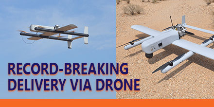
A record was recently set in long-distance delivery via drone. The record-breaking event took place May 5, 2017 and involved several key stakeholders. The Nevada UAS Consortium, dubbed Team Roadrunner, flew a fixed-wing Unmanned Aerial Vehicle (UAV) over 97 miles to Austin, Texas through use of cellular connectivity.  

Delivery via Drone

Launched from an urban location in central Texas, the UAV flew a pre-planned route through National Airspace System (NAS). Team Roadrunner used mobile command and control, a visual observer team, and stationary visual observers equipped with enhanced radios and cell phone communications which allowed the UAV to fly using a cellular communications link. The UAV successfully landed in Austin, Texas and delivered its package. Team Roadrunner consisted of the FAA-designated Nevada UAS Test Site, Volans-i UAS, Latitude UAS, AUV Flight Services. The team also included ground and mobile visual observer support from Embry-Riddle Aeronautical University (ERAU) Worldwide campuses. “This was the most challenging, logistically-intensive, and longest package delivery demonstration recorded to date using cellular technology in the NAS. It allowed us the opportunity to demonstrate innovative capability – a demonstration necessity for the UAS industry,” said Dr. Chris Walach, Director of the FAA-designated Nevada UAS Test Site and Adjunct Assistant Professor, College of Aeronautics at Embry-Riddle Aeronautical University Worldwide. “Assembling a resilient team, being at the right place at the right time with the right technology and entrepreneurial perspective helped us accomplish this mission.” Walach continued, “Drone package delivery in an urban and remote environment is the wave of the future. Nevada is leading and helping grow this major commercial endeavor. These milestones prove that technology enables the safe integration of UAS into the NAS for long-distance and urban package deliveries.” Nevada previously conducted historic package delivery BLOS demonstrations in Hawthorne, Nevada at over 39 miles as well as the first publicly-recorded package delivery to a Reno, Nevada homeowner.  

Safety precautions along the route

The operation included layers of safety. Along the flight path, the team stationed visual observers as well as a mobile team to cover remote areas. “It is very exciting to be part of something truly ground breaking. Integration of students and alumni on similar projects with NIAS in the future extends our outreach to the industry,” said Dr. Scott Burgess, Associate Professor, College of Aeronautics at Embry-Riddle Aeronautical University Worldwide. “Aviation has evolved much since the days of the Wright Brothers. I truly believe that unmanned systems are going to revolutionize the aviation industry and beyond. I am proud that Embry-Riddle faculty, students, and fellow Alumni are actively playing a part in this incredible journey,” said Kandi Windham, Campus Director, Embry-Riddle Aeronautical University Worldwide, Houston, Texas. “This mission was extremely complicated. Ensuring that the UAS met all the performance characteristics was only one piece. We placed great emphasis on flight safety, airworthiness, communication, command and control, air and ground coordination, and VO logistics. The Volans-i, Latitude, AUV Flight Services, and the NIAS team worked extremely well together. Given the complexity and the ultimate success of the mission, it is clear to me that we couldn’t have picked a better team,” said Hannan Parvizian, Volans-i Founder.  

Future of drone delivery

“Creating a safe and thriving drone industry is an incredible challenge, especially when coupled with drone package delivery. The loss of communications during a long flight is a real concern. This mission showed cellular technology can ensure communication with a drone is not lost over a long-distance delivery. The record-breaking success of Team Roadrunner’s aerial package delivery mission proves that diligent testing in complex conditions will lead to drone delivery becoming reality,” said Steve Hill, Executive Director of the Nevada Governor’s Office of Economic Development. The Nevada UAS Test Site is one of seven Federal Aviation Administration-designated UAS Test Sites. The Nevada UAS Test Site in consultation with the Lone Star UAS Test Site helped plan the mission.

Aeromapper Talon Completes Single-Flight Survey of Island in The Maldives

https://www.unmannedsystemssource.com/?s=aeromapper&post_type=product&product_cat=0In December Aeromao Inc., completed a full photogrammetric survey mission of an island with an Aeromapper Talon UAV...in one flight. The survey took place in collaboration with Foresight Surveyors. One of the most unique and exotic islands in the Maldives, the Talon surveyed a total area of approximately 251 acres or 1 Sq. Km. at a GSD of 2cm/pixel.
 

Talon Surveys Island

The Talon UAV flew at a cruise altitude of 100 m AGL and collected 1422 photos with an amazing level of detail. Pix4DMapper software generated a DSM, orthophoto and point cloud. Though the Aeromapper Talon has 2 hour flight endurance capability, the mission finished successfully in only 45 minutes. The UAV flew at a maximum distance from the ground control of 2km. Additionally, the Talon launched and was recovered via parachute from an island roughly 1 km away. The UAV flew without incident. The Aeromapper Talon was not equipped with PPK GNSS system, so 5 GCS points were taken on the island which resulted in a horizontal accuracy of 4.8cm  

The results

The purpose of the survey was to generate an ortho-photo to trace the "as-built" for future developments. Furthermore, the data provided clients with an up-to-date high resolution property map for the project department and decision makers. Also, the othophoto helped with their environmental monitoring and biodiversity mapping.
 

About the Maldives

The Maldives consists of 1,192 coral islands grouped in a double chain of 26 atolls. It spreads over roughly 90,000 square kilometers (35,000 sq mi) and is one of the world’s most dispersed countries. It lies between latitudes 1°S and 8°N, and longitudes 72° and 74°E. Composed of live coral reefs and sand bars, the atolls rise abruptly from the Indian Ocean. These islands are situated on a submarine ridge 960 kilometers (600 mi) long. Maldives is the lowest country in the world. As a result, its natural ground levels average only 2.4 meters (7 ft 10 in) and 1.5 meters (4 ft 11 in) above sea level. However, in areas where construction exists, ground levels have increased several meters.  

About Foresight Surveyors

The first company to introduce unmanned aerial vehicle mapping to the Maldives, Foresight Surveyors chose the Aeromapper Talon because of its ease of use, dependability and affordability. Foresight Surveyors provides a comprehensive range of surveying and survey related consultancy, including: topographical, bathymetry and engineering survey services. The company makes use of traditional techniques and modern technologies to produce accurate data.  

About Aeromao, Inc.

Founded in 2011, Aeromao Inc. is a leading manufacturer of UAVs. Aeromao developed the Aeromapper series of turnkey unmanned aerial vehicles for mapping, surveying, precision agriculture and remote sensing. Canada serves as the company's headquarters. Aeromao Inc. offers a line of products that adapt quickly to market demands and the unique needs of client applications. You can shop the entire line of Aeromapper UAVs at Unmanned System Source.

Ground-based delivery drones: set to cruise the sidewalks?

Ground-based delivery dronesCompanies from various sectors envision a future driven by artificial intelligence (AI) and automation. So far, much of the attention seemed focused on developing unmanned aerial vehicles. But not every company looked only to the skies...some had more terrestrial ideas in mind. Enter Starship Technologies, a start-up based in Estonia. The team at Starship created a line of autonomous ground based courier robots, or sidewalk delivery drones.  

Ground-based delivery drones

In recent months, both Amazon and Fed-Ex previewed their ideas about the future of package delivery via aerial drones. But these efforts face many challenges, the foremost of which is regulation. Other obstacles include the roll-out of this technology on a nationwide basis requires mass investment as well as consumer uptake. But there is little doubt that there is a strong appetite for reliable delivery solutions. And, finding an efficient way to automate the courier process is of great interest to numerous companies. Many companies are competing within this space to find the best solution. On the other hand, sidewalk delivery drones are already legal in a number of states. Starship Technologies focused on utilizing current infrastructure and new technologies, such as on-demand services, to bring goods to customers now. To launch its sidewalk delivery drones, the start-up partnered with logistics company Postmates to deliver food in Washington D.C. Starship also partnered with on-demand restaurant delivery service, DoorDash, to service customers in Redwood City, Calif. Starship calls its sidewalk delivery drone a “personal courier” and is designed to deliver small parcels within a 30-minute range. It is compact, about knee-high, and reaches speeds up to 4 miles per hour. For a delivery run, the personal courier travels on sidewalks and is outfitted with sensors and cameras so it can autonomously avoid obstacles. Customers access the contents of the delivery via an app.  

Pilot programs already in progress

Starship's technology is already legal in a number of states. Currently, pilot programs are operating in Virginia, California and Washington. In Virginia, the law allows the robots to operate on footpaths, sidewalks and crosswalks. The delivery drones are not permitted to travel over 10 mph and require remote access monitoring by operators. During the test phase, the delivery robots must make up to 10 deliveries a day and be accompanied by monitors to observe behavior and performance. Starship’s pilot programs with DoorDash and Postmates provide real-world practice and help work out the kinks. So far, the process is pretty cut and dry. A customer places an order, either online or via an app. The restaurant completes the order and loads the drone with the delivery. The drone proceeds to the delivery address.  

Seasoned creators

Founders Ahti Heinla and Janus Friis Visualise are former Skype co-founders. Starship is just their latest start-up to gain mainstream recognition. So far, the start-up has received millions of dollars in backing from a number of Venture Capital investors. In a sector that is still relatively young, Starship Enterprises has quickly become a pioneer in urban, on-demand delivery. Heinla and Visualise envision a future where delivery drones are a regular sight and responsibly share sidewalk space with pedestrians. In addition to the pilot programs in Washington and Redwood, the start up has made deliveries in over 40 European cities including London, where Starship partnered with JustEat. While Starship’s sidewalk delivery drones may not be the super speedy aerial solution that other retailers are seeking, the robots are currently a solid solution for deliveries in urban areas. Currently, these delivery robots are a great way to complement both human couriers and aerial drones, when they become approved. For now, Starships’s sidewalk robots are rolling ahead in the delivery drone race.

Phase One announces full integration of aerial cameras with DJI’s M600 and M600 Pro

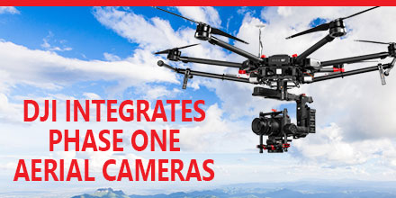
Phase One Industrial recently announced the full integration of its iXU and iXU-RS aerial cameras with DJI’s M600 and M600 Pro drones. Built using DJI’s SDK, this is just the latest drone platform supported by Phase One Industrial. Phase One was the first to deliver 100-megapixel medium format aerial cameras. Since then, Phase One has continued to innovate inspection tools uniquely capable of addressing diverse aerial imaging applications. Those applications range from photogrammetry to critical infrastructure to monitoring projects.  

High quality solution for aerial imaging applications

The aerial cameras’ integration with DJI’s M600 and M600 Pro platforms is delivering high quality solutions for aerial imaging applications. “Using the Phase One Industrial IXU camera with the new Integration package for our DJI M600 drone, the results were extraordinary,” said UAV Flight Systems Manager Tobias Wentzler, Lufthansa Aerial Services. “We achieved millimeter per pixel accuracy, allowing us to inspect the required objects in exquisite detail and lift our mission results and accuracy to a new, high-end level, identifying the subtlest cracks or imperfections that were not visible to conventional inspection methods.” Phase One continues to develop aerial imaging solutions that meet the exacting needs of aerial imaging professionals. “When our clients hire us, they expect the best,” said Ron Chapple, CEO of Aerial Filmworks. “With the new Phase One Industrial aerial cameras integrated with DJI drones, Aerial Filmworks delivers robust performance, highest resolution and finest image quality to support our clients’ cinematic projects. “GEO1, the survey division of Aerial Filmworks, a solutions-driven provider in the electric and gas/oil marketplace, also benefits from this development. Now, we have the right solution to help satisfy our clients’ requirements for the high-resolution data and flight efficiencies.”  

Capabilities include

Phase One Industrial iXU and iXU-RS aerial cameras’ integration with DJI M600 and M600 Pro drone systems include:
  • 100MP and 50MP metric aerial cameras
  • Smart triggering of the camera by waypoints / fixed distance / fixed time
  • Support for mission planning applications (such as DJI Ground Station pro) – for waypoints missions
  • Geo-tagging of all files’ location and gimbal position
  • Dual remote controllers (drone and camera) enable each operator (UAV pilot and camera operator) to focus on their respective mission goals
  • Industrial-grade build of the camera and aerial lenses for use in harsh environments
Also, the integration provides a new iX Capture Mobile application for iOS. This application features an intuitive, user-friendly interface, and support for total remote control of the camera.  

Phase One DJI Integration

Designed using the DJI open platform development tools, iX Capture Mobile offers various operating modes, including:
  • Video Streaming
  • Auto or Manual Capture settings to determine the values of the ISO, shutter speed and aperture
  • Auto capture mode to enable image capturing by waypoints, fix distance or by time intervals
  • Camera control via DJI Lightbridge 2 dials
The iXU and iXU-RS series of high-resolution, metric cameras are known for precision imaging, small size and low weight. In addition, these cameras offer direct integration with other UAV manufacturers, including: Coptersystems, AerialTronics, Pulse Aero, and UMS Skeldar platforms. They also support the workflows of many leading image post processing software, such as: Pix4D, Agisoft, SimActive, and others. Designed to capture images with superior accuracy and quality, Phase One Industrial aerial cameras are capable of covering larger aerial surfaces in less time, resulting in less flight time needed for efficient flying. As such, operators can enjoy both unprecedented visibility and a lower cost by utilizing drones rather than traditional airplane or helicopter methods. In addition, drones offer improved worker safety across challenging environments, including: power line monitoring, inspection of wind turbines, railways, roads, bridges and other civil engineering jobs. Phase One iXU and iXU-RS series camera systems are available immediately from partners worldwide, including Unmanned Systems Source. Camera package prices begin from $29,000 (complete with integration kit and lens). For more information, please contact Unmanned Systems Source.

Visit Booth 325 at XPONENTIAL to meet the Unmanned Systems Source Team

May 9, 2017 – Unmanned Systems Source is looking forward to connecting with clients, vendors and friends May 8-11 at the XPONENTIAL show in Dallas, TX. Unmanned Systems Source provides users a single source of supply and information for unmanned and remote sensing applications. “We are often referred to as the ‘Amazon’ of the Unmanned world,” said Jennifer Jerrick, CEO of Unmanned Systems Source. “Prosumers, developers, manufacturers, and procurement agents, alike, can find what they need to outfit their unmanned projects. We are a one-stop-shop.” Unmanned Systems Source, though, is more than just an e-commerce site.  

Industry experience, customer support

“The level of service and support our team provides customers is one of the key factors that distinguishes us within the marketplace,” said Jerrick. “Our industry experienced Solution Engineers listen, answer questions and help customers select the right systems, payloads and peripherals for their application.” Thanks to numerous distribution partnerships with recognized manufacturers, the product offering at Unmanned Systems Source continues to grow. Customers can shop, compare and buy top-tier products at retail pricing…or better.  

About Unmanned Systems Source

Unmanned Systems Source is an online warehouse that supplies unmanned systems, components, subsystems, and services. With more than 30 years combined experience, the team at Unmanned Systems Source has the insight to help power projects for commercial, governmental, and public sectors, alike. Visit booth 325 to find out how Unmanned Systems Source can create buying and procurement solutions for your projects.