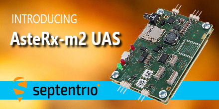
May 8, 2017 - Septentrio, a leading manufacturer of accurate and reliable GNSS solutions, announced the release of the AsteRx-m2 and AsteRx-m2 UAS OEM boards.
These OEM boards bring the latest in GNSS positioning to the market with unmatched interference mitigation technology all on ultra-low-power.
Septentrio will showcase these OEM boards in Dallas, Texas at AUVSI's Xponential 2017.
Centimeter-level RTK position accuracy, and more
The credit-card sized AsteRx-m2 and the AsteRx-m2 UAS offer all-in-view multi-frequency, multi-constellation tracking and centimeter-level RTK position accuracy for the lowest power of any comparable receiver. Additionally, the AsteRx-m2 and the AsteRx-m2 UAS can receive TerraStar satellite-based correction signals for PPP positioning.
Also, both boards feature Septentrio’s AIM+ interference mitigation system: the most advanced on-board interference mitigation technology on the market. It can suppress the widest variety of interferers, from simple continuous narrowband signals to wideband and pulsed jammers.
Increased levels of radio frequency pollution coupled with the intrinsic danger of self-interference in compact systems such as UAS, makes interference mitigation vital to any UAS GNSS system.
AsteRx-m2 UAS for unmanned systems
The AsteRx-m2 UAS is designed specifically for unmanned systems. It brings plug-and-play compatibility for autopilot software such as ArduPilot and Pixhawk. And event markers can accurately synchronize a camera shutter with GNSS time.
In addition, the board can receive power directly from the vehicle power bus via its wide-range power input. The AsteRx-m2 UAS works seamlessly with GeoTagZ software and its SDK library for RPK (ReProcessed Kinematic) offline processing to provide RTK accuracy without the need for ground control points or a real-time datalink.
“The market demands increasingly accurate and reliable GNSS positioning systems for inspection, mapping and aerial survey” stated Gustavo Lopez, Product Manager at Septentrio. “Septentrio’s answer is the AsteRx-m2 and the AsteRx-m2 UAS. They offer multi-frequency and multi-constellation tracking as well as robust interference protection all for the lowest power on the market.”
If attending XPONENTIAL, find out more about the AsteRx-m2 UAS by stopping by Septentrio's booth, #749, or Unmanned Systems Source at booth #325.
About Septentrio
Septentrio designs, manufactures and sells high-precision multi frequency multi constellation GPS/GNSS equipment. Receivers, designed by Septentrio, deliver consistently accurate GNSS positions scalable to centimeter-level. They perform solidly even under heavy scintillation or jamming. Receivers are available as OEM boards, housed receivers and smart antennas.
Shop Septentrio's line of GNSS receiver solutions at Unmanned Systems Source.
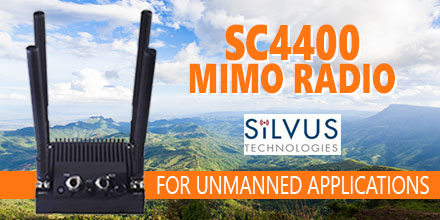
Silvus Technologies is preparing to showcase its new StreamCaster 4400 radio at the upcoming AUVSI XPONENTIAL show in Dallas, TX.
The SC4400 is a 4×4 MIMO radio designed for unmanned systems applications. It transmits high-definition video, data and communications at near zero latency over long distances.
Also, it can deploy as a point-to-point data link or as part of a comprehensive, self forming/self healing mesh network. And it intelligently optimizes signal transmission in both line-of-sight and non-line-of-sight operations.
SC4400 Mimo Radio
The SC4400 MIMO Radio utilizes four antennas for true 4×4 MIMO. It comes equipped with standard connections including: Ethernet, USB, Push-To-Talk voice, RS-232 and a Wi-Fi port for connecting a phone, tablet or laptop to access the StreamScape user interface.
This comprehensive network manager allows users to monitor signal strength, data rates and radio stats, and to test links and make adjustments. The spectrum scan diagnostic tool enables the user to analyze the available range of frequencies and select a channel that is free of interference. An embedded mapping display also enables nodes to be tracked in real time, providing a bird’s eye view of the entire system.
“The StreamCaster 4400 delivers a significant increase in range and overall robustness, making it a great fit for larger aircraft,” said Silvus Technologies Director of Sales, Kasey Cooper. “Our existing StreamCaster 4200 radio is also getting an upgrade with dual band capability, providing the ability to tune across two disparate bands for maximum reliability in a smaller form-factor. Together, the StreamCaster 4200 and the more powerful StreamCaster 4400 can combine to optimize video, command and control and bi-directional data transmission for UAVs of any size, in any range.”
About Silvus Technologies
Silvus Technologies develops military-grade Mobile Networked MIMO (MN-MIMO) waveform technology, which comprises the core of the SC4400 MIMO Radio. Its distinctive beam-forming ability boosts signal strength, reducing power consumption while increasing overall range.
Silvus claims that the SC4400 is the world’s first tactical MIMO radio to employ 4×4 MIMO transmit beam-forming, an advanced method of signal processing that is capable of doubling transmission distance reach. MIMO’s tenacious ability to bounce off obstacles and reroute signals also features prominently in the SC4400.
“We’ll be performing live demos on the show floor to give just a small taste of the kind of wireless connectivity we can achieve,” added Cooper. “We’ll be showing how our StreamCaster radios operate with the latest UAVs and subsystems from Overwatch, Latitude and Isensys, to name a few.”
If you're attending XPONENTIAL, stop by booth 518 to watch Silvus Technologies demo the SC4400. And make sure you stop and visit Unmanned Systems Source at booth 325. You can shop Silvus' line of MIMO radios at Unmanned Systems Source.
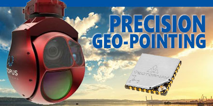
Octopus ISR Systems, a division of UAV Factory Ltd., announced the release of a new feature, "Precision Geo-Lock", for its miniature Epsilon series of gyro-stabilized gimbals.
Precision Geo-Lock combines a state-of-the-art GPS-aided inertial navigation system (GPS/INS) with dedicated software algorithms and payload operator software. It provides the user with highly accurate target geo-location, range-to-target, as well as Geo-Lock functionality and moving map user interface.
Precision geo-location challenges
Equipping a miniature airborne gimbal with precision geo-location presents a multitude of challenges. First, the gimbal operates in a high vibration environment, high accelerations and extreme ranges in temperature. Also, unmanned aircraft often use miniature gyro-stabilized gimbals. Thus, small size and low power consumption are significant factors.
“Traditionally, small gyro-stabilized gimbals use an external heading source to estimate the geo-location of the target,” stated UAV Factory CEO Konstantins Popiks. “Onboard the unmanned aircraft, the attitude data is usually supplied by an autopilot. The estimate accuracy is imprecise due to the nature of low-cost sensors used in miniature autopilots. Miniature autopilots simply do not need the precise heading data required by the gimbal. As a result, the heading error generates large geo-location errors and provides little to no use for the unmanned aircraft operator. Additional errors occur due to misalignment of the gimbal and autopilot; these are separate subsystems mounted in different locations on individual soft vibration mounts.”
For the Geo-Lock feature to work, a highly accurate external GPS/INS needed to be integrated into the system.
“Today the state-of-the-art miniature gyro-stabilized gimbals have a narrow field of view of less than 1.3 degrees," said Popiks. "Therefore, pointing accuracy should be significantly better than 1.3° to prevent the target pointing location from going out of frame.”
VectorNav VN-200
In order to guarantee the successful implementation of the Precision Geo-Lock feature, UAV Factory partnered with VectorNav Technologies. VectorNav develops and manufactures high performance inertial navigation systems using the latest in MEMS sensor and GPS/GNSS technology.
“VectorNav’s VN-200 was the only product on the market that offered a high-level of performance but small enough form factor for direct integration into the optical bench of the gimbal” said Popiks. “When the product delivered that level of accuracy despite the high vibrations, accelerations and temperature fluctuations of our application the choice was obvious.”
UAV Factory’s Precision Geo-Lock provides better than 0.3 degree accuracy and is ‘Plug-and-Play’. This allows the customer to install the Epsilon gimbal and get accurate results on any platform and in a high-vibration environment.
Epsilon gyro-stabilized turrets will be available with VN-200 single GPS-based INS solution, as well as the VN-300 dual GPS-based INS. A single GPS/INS solution is suitable for dynamic platforms such as manned and unmanned aircraft. Dual GPS/INS is a necessity for platforms with low dynamics, such as aerostats, ships and helicopters.
You can shopVectorNav's entire line of sensorsat Unmanned Systems Source.
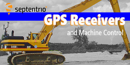
Looking for a GPS receiver for moving earth, mining or construction? Consider the following...
GPS receivers can assist operators in making better decisions by providing precise position information (indicate-only mode). Or the GPS receiver, as part of a guidance system, can take over the operation of the machine’s implement itself (fully-automatic mode) to follow a preloaded design.
In fully-automatic mode, the RTK centimeter-level precision of the GPS guidance system is far more accurate and consistent than relying on the operator’s skill alone.
Trenches are dug to exact depths, tractors are steered in perfect rows, piling rigs know the precise location for planting piles and surfaces are fine graded the first time. Work is completed quicker, more cheaply and to a higher specification when the need to carry out frequent measurements and surveys is not needed.
Compared to a Total Station, a GPS RTK system setup is quick and doesn’t require any of the elements to be in line of sight. A single reference base station can furnish all rover machines on-site continuously with RTK differential corrections. The status of the project and location of every machine on-site is updated in real-time giving site managers a full overview of progress.
GPS Receivers
Machine control applications are among the most challenging for GPS receivers. The physical and radio environments can be difficult enough but operators will always try to push their equipment to its limits. So what GPS receiver capabilities are needed for consideration as a suitable candidate for machine control? There are six prime considerations.
AsteRX4 GPS receiver at work helping plant trees
1) Position precision in difficult conditions
In RTK mode, using a base station that’s not too far away, high-end GPS receivers calculate position with a precision of less than 1 centimeter (0.4 inch). Difficult conditions can degrade the position precision and can even result in wrong position fixes.
Construction sites present their own set of challenges. Large structures and other machines nearby can cause multi-path. Foliage can be particularly problematic for GPS signal quality. And operators can’t always be assured of a clear view of the sky.
Any GPS receiver worth its salt should be adeptly manage the typical conditions on a building site. The consequences of a wrong position fix can be costly and time consuming. A piling operator needs the exact position and orientation of the rig to plant a pile. After all, there are far better ways to spend time than extracting wrongly-placed piles.
2) Low latency and high data output rate
Latency is the time it takes for the receiver to calculate and output a position. Lower latencies and higher position update rates provide more responsive machines that operate at higher speeds without loss of performance.
The highest performing GPS receivers today can output data at upwards of 50 Hz with latencies of less than 20 ms.
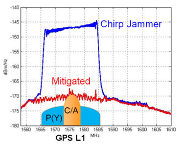
AsteRx-U spectrum analyser in the presence of a chirp jammer both before (blue) and after (red) activation of AIM+
3) Interference mitigation
A delivery vehicle arriving on-site with a chirp jammer can knock out RTK and bring operations to a standstill. The prevalence of such devices, as well as interference from other non-intentional sources continues to increase. Interference mitigation is now an essential tool for a machine control receiver.
Today's highest performing GPS receivers can mitigate against simple continuous narrow-band and pulsed interferers as well as more complex wide-band transmitters such as chirp jammers and other PPDs (Personal Privacy Devices).
4) Heading
Machines such as excavators have a platform that rotates independently of the undercarriage. To know the position of the bucket, the operators must also know the orientation (or heading) of the platform. Depending on placement, two antennas allow the GPS receiver to calculate the heading of the platform as well as either the pitch or the roll.
5) Robust against heavy vibrations and bumps
Rough terrain can play havoc with GPS signal tracking. Without an adaptive-bandwidth tracking-loop mechanism, the receiver may lose tracking during periods of heavy vibration.
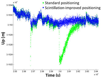
Calculated antenna height with (blue) and without (green) ionospheric scintil-lations mitigation (IONO+) activated
6) Resistance to ionospheric disturbance
We’re currently winding down from the last solar-activity peak in 2014. However, ionospheric disturbance of GPS signals are still problematic around the equator and at higher latitudes. Ionospheric scintillation mitigation ensures GPS output remains predictable and that RTK positioning is maintained.
More than shifting earth
Today, a wide variety of applications use GPS receivers. From seismic monitoring and timing to on-board dredgers and drones, GPS receivers provide high-precision positioning or timing when needed.
If your applications requires this level of precision, make sure you check out Septentrio's line of solutions at Unmanned Systems Source.
April 4, 2017 – Unmanned Systems Source is pleased to announce a new distribution partnership with MicroPilot, producers of full-featured UAV autopilots.
“MicroPilot is a world leader in small autopilot systems for UAS,” said Drew Osbrink, Business Development Director for Unmanned Systems Source.
"The MicroPilot product line is a great fit for customers looking for a reliable solution to manage complex autonomous behaviors for their UAS platforms,” said Osbrink.
Introduced in 2004 and weighing only 28 grams, MicroPilot's MP2x28g2 raised the bar around the world for functionality and value in small UAV autopilots. Paired with this full-feature UAV autopilot, the MicroPilot HORIZONmp ground control software provides a user-friendly, point-and-click interface for mission planning, parameter adjustment, flight monitoring, and mission simulation.
Building on the success of these proven innovations, MicroPilot now offers a series of autopilots, software, accessories, and customized UAV training and integration services.
MicroPilot autopilot solutions
Small size without sacrificing functionality: 28 grams, 4 cm by 10 cm
GPS waypoint navigation with altitude and airspeed hold
Completely independent operation, including autonomous takeoff, bungee launch, hand launch, and landing
Powerful script language command set
Open architecture – all state fields fully accessible
Fully integrated with 3-axis gyros and accelerometers, GPS, pressure altimeter, pressure airspeed sensors, all on a single circuit board
Extensive data logging and telemetry capabilities
UAV configuration wizard and installation video simplify installation
Includes HORIZONmp ground control software
Seamless upgrade path
From the single-use autopilot (MP2x28xp) to the powerful VTOL autopilot (MP2128HELI), MicroPilot provides a seamless upgrade path. No other autopilot manufacturer offers this high degree of adaptable technology and range of autopilot options.
Once an individual learns how to operate a MicroPilot autopilot, the knowledge translates across the product line. This makes MicroPilot the single-vendor solution for autopilot hardware, software, and accessory needs. MicroPilot’s line of autopilots allows customers to grow and adapt at a fraction of the cost offered by many competitors.
Visit Unmanned Systems Source to learn more about MicroPilot's autopilot solutions.
About MicroPilot
Incorporated in 1994, MicroPilot serves UAV manufacturers who maintain high standards for both the hardware they integrate into their systems and the software that drives them.
MicroPilot customers require products that are reliable, scalable and customizable. They have a solid reputation that supplies consistent products, services and support. MicroPilot has maintained itself as the world leader in professional autopilots for UAVs and MAVs.
March 23, 2017 – Unmanned Systems Source is pleased to announce a new distribution agreement with SPH Engineering.
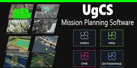
SPH Engineering is the creator of the popular UgCS Mission Planning Software which provides central management of all types and manufacturers of UAVs. It supports both fixed wing and multi-rotor platforms.
Supported platforms, include: DJI Phantom 4 / 4 Pro, Phantom 3 and Phantom 2, Inspire 2, Inspire 1 / 1 Pro / Raw, Mavic Pro, A3, N3, Matrice 600 / 600 Pro, Matrice 100, A2, Naza-M v2, WooKong-M, Vision2+, Ace One.
Currently, supported autopilots, include: Ardupilot, Px4 and other MAVLink compatible; InnoFlight: Jupiter JM-1; Mikrokopter; Micropilot; Microdrones; LockheedMartin: Kestrel, Indago.
"UgCS software is a great addition to our site," said Andrew Osbrink, Business Development Director at Unmanned. "Whether a customer operates a fixed wing or multi-rotor, many crafts or just one, UgCS' flexible licensing model means organizations can purchase the license that works for their situation."
The UgCS Desktop Solution
UgCS software has convenient tools for areal and linear surveys and provides direct drone control. Its modular architecture means ease of integration and simplifies adding support for new vehicles or payloads. Other features include easy route creation, an immersive 3D mission planning environmental and No-Fly zone support. In addition, it has built-in photogrammetry and geotagging tools, map customization, and more.
Users can control one or a fleet of drones on a single mission, in multi-operator mode and in multi-platform environments.
UgCS Mission Planning software options
OPEN is the free version of UgCS software. It offers limited capabilities in terms of the range of operations, functionality and support. However, it allows users insight into the software before making a purchasing decision.
For UAV hobbyists and non-professional users, the ONE license is recommended. It provides unlimited range of operations with some limitation of the advanced functions.
The PRO license is recommended for UAV professionals and land surveyors. It is the fully functional, multi-drone ground control software for professional UAV mission planning. Includes photogrammetry tools, digital elevation model (DEM) and KML file import to enable map customization. It also offers ADS-B receiver support to ensure flight safety.
And finally, the ENTERPRISE license is for companies that operate a fleet of different manufacturer drones requiring a unifying ground station solution. Features ADS-B transponder support, multi-node deployment enables operation of a central server with unlimited connection to UgCS universal control server.
About SPH Engineering
Founded in 2013, SPH Engineering employs both professionals and enthusiasts. They turn client ideas into products that address specific needs and requirements. Technology is not just a product for SPH Engineering, it's their passion.
Visit Unmanned Systems Source to shop and compare UgCS Mission Planning license plans to find the one that is right for you.

 May 8, 2017 - Septentrio, a leading manufacturer of accurate and reliable GNSS solutions, announced the release of the AsteRx-m2 and AsteRx-m2 UAS OEM boards.
These OEM boards bring the latest in GNSS positioning to the market with unmatched interference mitigation technology all on ultra-low-power.
Septentrio will showcase these OEM boards in Dallas, Texas at AUVSI's Xponential 2017.
May 8, 2017 - Septentrio, a leading manufacturer of accurate and reliable GNSS solutions, announced the release of the AsteRx-m2 and AsteRx-m2 UAS OEM boards.
These OEM boards bring the latest in GNSS positioning to the market with unmatched interference mitigation technology all on ultra-low-power.
Septentrio will showcase these OEM boards in Dallas, Texas at AUVSI's Xponential 2017.
 Silvus Technologies is preparing to showcase its new StreamCaster 4400 radio at the upcoming AUVSI XPONENTIAL show in Dallas, TX.
The SC4400 is a 4×4 MIMO radio designed for unmanned systems applications. It transmits high-definition video, data and communications at near zero latency over long distances.
Also, it can deploy as a point-to-point data link or as part of a comprehensive, self forming/self healing mesh network. And it intelligently optimizes signal transmission in both line-of-sight and non-line-of-sight operations.
Silvus Technologies is preparing to showcase its new StreamCaster 4400 radio at the upcoming AUVSI XPONENTIAL show in Dallas, TX.
The SC4400 is a 4×4 MIMO radio designed for unmanned systems applications. It transmits high-definition video, data and communications at near zero latency over long distances.
Also, it can deploy as a point-to-point data link or as part of a comprehensive, self forming/self healing mesh network. And it intelligently optimizes signal transmission in both line-of-sight and non-line-of-sight operations.
 Octopus ISR Systems, a division of UAV Factory Ltd., announced the release of a new feature, "Precision Geo-Lock", for its miniature Epsilon series of gyro-stabilized gimbals.
Precision Geo-Lock combines a state-of-the-art GPS-aided inertial navigation system (GPS/INS) with dedicated software algorithms and payload operator software. It provides the user with highly accurate target geo-location, range-to-target, as well as Geo-Lock functionality and moving map user interface.
Octopus ISR Systems, a division of UAV Factory Ltd., announced the release of a new feature, "Precision Geo-Lock", for its miniature Epsilon series of gyro-stabilized gimbals.
Precision Geo-Lock combines a state-of-the-art GPS-aided inertial navigation system (GPS/INS) with dedicated software algorithms and payload operator software. It provides the user with highly accurate target geo-location, range-to-target, as well as Geo-Lock functionality and moving map user interface.
 GPS receivers can assist operators in making better decisions by providing precise position information (indicate-only mode). Or the GPS receiver, as part of a guidance system, can take over the operation of the machine’s implement itself (fully-automatic mode) to follow a preloaded design.
In fully-automatic mode, the RTK centimeter-level precision of the GPS guidance system is far more accurate and consistent than relying on the operator’s skill alone.
Trenches are dug to exact depths, tractors are steered in perfect rows, piling rigs know the precise location for planting piles and surfaces are fine graded the first time. Work is completed quicker, more cheaply and to a higher specification when the need to carry out frequent measurements and surveys is not needed.
Compared to a Total Station, a GPS RTK system setup is quick and doesn’t require any of the elements to be in line of sight. A single reference base station can furnish all rover machines on-site continuously with RTK differential corrections. The status of the project and location of every machine on-site is updated in real-time giving site managers a full overview of progress.
GPS receivers can assist operators in making better decisions by providing precise position information (indicate-only mode). Or the GPS receiver, as part of a guidance system, can take over the operation of the machine’s implement itself (fully-automatic mode) to follow a preloaded design.
In fully-automatic mode, the RTK centimeter-level precision of the GPS guidance system is far more accurate and consistent than relying on the operator’s skill alone.
Trenches are dug to exact depths, tractors are steered in perfect rows, piling rigs know the precise location for planting piles and surfaces are fine graded the first time. Work is completed quicker, more cheaply and to a higher specification when the need to carry out frequent measurements and surveys is not needed.
Compared to a Total Station, a GPS RTK system setup is quick and doesn’t require any of the elements to be in line of sight. A single reference base station can furnish all rover machines on-site continuously with RTK differential corrections. The status of the project and location of every machine on-site is updated in real-time giving site managers a full overview of progress.

 April 4, 2017 – Unmanned Systems Source is pleased to announce a new distribution partnership with MicroPilot, producers of full-featured UAV autopilots.
“MicroPilot is a world leader in small autopilot systems for UAS,” said Drew Osbrink, Business Development Director for Unmanned Systems Source.
"The MicroPilot product line is a great fit for customers looking for a reliable solution to manage complex autonomous behaviors for their UAS platforms,” said Osbrink.
Introduced in 2004 and weighing only 28 grams, MicroPilot's MP2x28g2 raised the bar around the world for functionality and value in small UAV autopilots. Paired with this full-feature UAV autopilot, the MicroPilot HORIZONmp ground control software provides a user-friendly, point-and-click interface for mission planning, parameter adjustment, flight monitoring, and mission simulation.
Building on the success of these proven innovations, MicroPilot now offers a series of autopilots, software, accessories, and customized UAV training and integration services.
April 4, 2017 – Unmanned Systems Source is pleased to announce a new distribution partnership with MicroPilot, producers of full-featured UAV autopilots.
“MicroPilot is a world leader in small autopilot systems for UAS,” said Drew Osbrink, Business Development Director for Unmanned Systems Source.
"The MicroPilot product line is a great fit for customers looking for a reliable solution to manage complex autonomous behaviors for their UAS platforms,” said Osbrink.
Introduced in 2004 and weighing only 28 grams, MicroPilot's MP2x28g2 raised the bar around the world for functionality and value in small UAV autopilots. Paired with this full-feature UAV autopilot, the MicroPilot HORIZONmp ground control software provides a user-friendly, point-and-click interface for mission planning, parameter adjustment, flight monitoring, and mission simulation.
Building on the success of these proven innovations, MicroPilot now offers a series of autopilots, software, accessories, and customized UAV training and integration services.
 March 23, 2017 – Unmanned Systems Source is pleased to announce a new distribution agreement with SPH Engineering.
SPH Engineering is the creator of the popular UgCS Mission Planning Software which provides central management of all types and manufacturers of UAVs. It supports both fixed wing and multi-rotor platforms.
Supported platforms, include: DJI Phantom 4 / 4 Pro, Phantom 3 and Phantom 2, Inspire 2, Inspire 1 / 1 Pro / Raw, Mavic Pro, A3, N3, Matrice 600 / 600 Pro, Matrice 100, A2, Naza-M v2, WooKong-M, Vision2+, Ace One.
Currently, supported autopilots, include: Ardupilot, Px4 and other MAVLink compatible; InnoFlight: Jupiter JM-1; Mikrokopter; Micropilot; Microdrones; LockheedMartin: Kestrel, Indago.
"UgCS software is a great addition to our site," said Andrew Osbrink, Business Development Director at Unmanned. "Whether a customer operates a fixed wing or multi-rotor, many crafts or just one, UgCS' flexible licensing model means organizations can purchase the license that works for their situation."
March 23, 2017 – Unmanned Systems Source is pleased to announce a new distribution agreement with SPH Engineering.
SPH Engineering is the creator of the popular UgCS Mission Planning Software which provides central management of all types and manufacturers of UAVs. It supports both fixed wing and multi-rotor platforms.
Supported platforms, include: DJI Phantom 4 / 4 Pro, Phantom 3 and Phantom 2, Inspire 2, Inspire 1 / 1 Pro / Raw, Mavic Pro, A3, N3, Matrice 600 / 600 Pro, Matrice 100, A2, Naza-M v2, WooKong-M, Vision2+, Ace One.
Currently, supported autopilots, include: Ardupilot, Px4 and other MAVLink compatible; InnoFlight: Jupiter JM-1; Mikrokopter; Micropilot; Microdrones; LockheedMartin: Kestrel, Indago.
"UgCS software is a great addition to our site," said Andrew Osbrink, Business Development Director at Unmanned. "Whether a customer operates a fixed wing or multi-rotor, many crafts or just one, UgCS' flexible licensing model means organizations can purchase the license that works for their situation."
