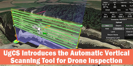
 UgCS’s new automatic Facade Scan tool for drone inspection mission planning is a time and cost saver for construction, engineering and mining industries.
Tools for surveying horizontal surfaces — even uneven ones — are widely available on the market and have been for some time. However, inspecting vertical surfaces is a completely different story. Previously, vertical surface inspection was a burden for professional drone users because it required a lot of manual work. But, thanks to the automatic Facade Scan tool from UgCS, that burden is no more.
The new Facade Scan tool has many applications for construction, architecture and other industries. The tool creates accurate digital models of buildings or cultural heritage objects. Plus, it identifies heat leaks and damage to walls.
Facade Scan allows the drone operator to draw a vertical plane, specify the distance to the wall as well as side and forward overlap. Once complete, it automatically calculates the optimal flying path. UgCS also supports the import of 3D objects and custom DEM data using the terrain-following function.
The tool makes it possible to examine open quarries for mining applications. These inspections via drone provide cost savings measures and keep humans from dangerous work. Drones can survey even unstable pits from a safe distance; the data gathered is much more accurate compared to other methods that don’t involve workers climbing down the pit. As mines often change due to work and natural conditions, repeated drone inspections bring data up-to-date in a fast and convenient way.
“With its choice of automatic and manual tools, UgCS is extremely versatile and suitable even for the most specific needs,” says one mining professional. “We can use several different drones for the same mission, or a number of different drones with different kinds of sensors. If a drone runs out of battery, there is no need to start a new mission — it can be resumed where it was interrupted. We also appreciate the terrain following mode that allows drones to follow the surface accurately. We use it for both horizontal and vertical surveys.”
Facade scan is part of the UgCS 3.2 release. It joins the family of other automatic UgCS tools: the Photogrammetry tool, Search Pattern tool and Area scan. It is available under a lifetime license, or a subscription based license of 1 and 3 months. UgCS supports most DJI drones, as well as MAVLink compatible and other UAVs. SPH Engineering continues to support and update the Facade Scan tool and welcomes comments from professional drone users across all industries.
Find out more about UgCS Mission Planning Software at Unmanned Systems Source.
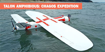 In May 2018, an expedition to the British Indian Ocean Territory launched to study the distribution of megafauna across the Chagos Archipelago. Melissa Schiele, MSc student from Imperial College London, joined the expedition. Schiele also brought an amphibious drone — the Aeromapper Talon — to conduct the surveys.
“I was thrilled when Dr. Tom Letessier from Zoological Society of London (ZSL) chose me to help with his drone research as part of the Bertarelli Programme in Marine Science,” said Schiele. “Our plan was to survey some of the islands of the Chagos Archipelago to compare distributions of megafauna around islands with nesting birds to islands with invasive rats.”
To accomplish this task, Schiele researched possible drones.
“To our knowledge, no one had a fixed-wing water landing drone,” said Schiele.
Fortunately for Schiele, there was one such drone that fit the bill — the amphibious Aeromapper Talon manufactured by Aeromao Inc.
The use of Unmanned Aerial Vehicles (UAV) or drones, is gaining traction in the world of ecology and conservation. In marine environments, scientists are testing the feasibility of drones to locate megafauna as well as map large areas. Initial results are promising across the board.
Many are looking to drones to bridge the gap between ground truthing surveys (diving transects, etc.) and large-scale plane based surveys, which cover thousands of kilometers.
“In April 2018, I flew to Aeromao headquarters in Canada to learn how to fly our new drones. Aeromao created the Talon – a waterproof fixed-wing drone capable of flying huge distances with the strength, stability and mechanisms of a small plane. With a two-meter wingspan, the units looked impressive. After a week of training and a successful water landing on Lake Erie, I packed up the two drones and flew from Toronto to the Maldives.”
“Our first deployment and retrieval of the Talon was a success. Plus, we captured our first aerial footage,” said Schiele. “The drones were equipped with two cameras. One was on the belly of the fuselage; it took snapshots every second. The other camera was in the clear nose cone. It allowed live streaming of the drone flight to a screen used by the drone pilot. The images proved our original concept worked and we were able to pin point sharks, birds and large fish.”
Overall, the Talon performed well. There were some small water entry points which is being addressed. We also lost a few days to poor weather. For safety reasons, we did not fly in strong winds and there was little sense flying in rain.
By the end of the three-week expedition, we had a suite of images and two drones in need of some TLC.
This expedition is just the beginning of a very exciting, international effort into the use of water landing drones for use in marine ecology. We are learning from any mistakes we make and becoming deft at drone mechanics, too,” said Schiele.
The Amphibious version of the Aeromapper Talon allows maritime operations by autonomously belly landing on water. Learn more about the Talon Amphibious and shop the entire line of Aeromapper UAVs at Unmanned Systems Source.
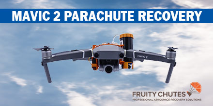 Introducing the first parachute system for the DJI Mavic 2. Designed by Fruity Chutes, the Mavic 2 Automatic Emergency Drone Parachute is lightweight, easy to use and reliable.
Easy to use, operators can pack and load the parachute without the need to send it back to the manufacturer after each use.
In addition, the parachute system is reusable. Included in the kit is a small rigger jig which allows operators to easily refold and pack the parachute.
The Mavic 2 parachute uses the same technology as the Mavic Pro parachute. To launch the parachute, the bundle comes equipped with the Harrier 40mm parachute launcher.
The Harrier features a high-energy compression spring that quickly ejects the parachute out and away from the Mavic 2. With no regulatory or transportation limitations, operators can take the launcher and Mavic 2 with your Fruity Chutes parachute system anywhere.
The centerpiece of the parachute system is the Fruity Chutes Iris Ultra Light parachute. Weighing just 0.96oz (27.7g), the parachute can easily work at heavier load weights of 2.4Kg or more.
The Mavic 2 bundle includes a high tech integrated nylon printed mount that wraps snug around the center of the copter. As such, there is no need for screws. The mount holds the Harrier 40mm launcher on one side and the automatic trigger system (ATS), battery and optional manual rescue radio receiver on the other side. It provides good clearance between the prop tips and the parachute launcher components.
The parachute system is entirely self-contained and does not rely on the Mavic 2 power. As such, it works even if the copter’s battery experiences complete failure.
The automatic trigger system (ATS) detects if the drone suddenly falls, rolls or flips. Detection of a fall typically takes just 0.75 seconds, or about 15 feet of free fall. By the time the pilot notices a problem, the parachute is already ejected.
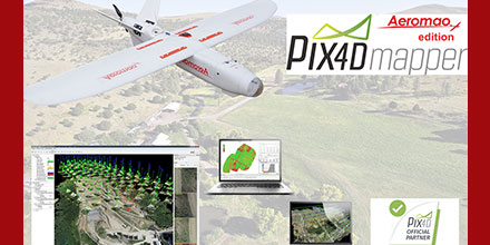 In celebration of its fourth year as an official partner of Pix4D, Aeromao has special offers on Pix4DMapper Aeromao edition and other Pix4D related products.
These offers expire December 31, 2018.
The Pix4DMapper Aeromao Edition is a fully featured image processing software package that is bundled with any Aeromapper UAV system. The package includes two perpetual licenses.
In addition, this bundled offer provides more savings than if purchased separately.
For example, the Aeromapper Talon — Aeromao’s flagship UAV system — sells for less than $16,000 USD. Now, this price includes the Pix4DMapper Aeromao edition, as well.
The Aeromapper Talon is a fixed-wing commercial turnkey UAV system. It is ideal for large area mapping, Beyond Visual Line of Sight (BVLOS) operations and optional Post-Processed Kinematic (PPK) for survey-grade results. It includes a wide range of optional swappable sensors: thermal, multispectral as well as surveillance camera packages.
Additionally, Aeromao offers stand alone licenses, educational packages or volume discounts in a quick turnaround time.
Since 2013, Aeromao has been an official partner and reseller of Agisoft Photoscan and all its related products.
Aeromao is Canada’s leading UAV manufacturer and developer of the Aeromapper series of turnkey unmanned aerial vehicles. With exports to more than 45 countries since 2012, Aeromao Inc. offers a line of products that adapt very quickly to market demands and to unique client’s applications, where no other UAV manufacturer goes.
 The AsteRx-i S combines Septentrio’s compact, multi-frequency multi-constellation GNSS engine with ultralight external industrial grade MEMS based IMU.
Calibrated for wide temperature ranges, the AsteRx-i S delivers accurate and reliable GNSS/IMU integrated positioning to the cm-level as well as full attitude at high update rates and low latency.
The AsteRx-i S is designed around demanding requirements for size, weight, power consumption and temperature variation. It is ideal for various applications such as inspection with UAV’s, UAS photogrammetry, automation, robotics, and logistics.
“We are delighted to broaden our AsteRx-i GNSS/INS solutions range, bringing maximum flexibility and choice to our customers. Whether for direct georeferencing in mapping applications with UAVs, for managing containers in a port or for innovative small robots in agriculture, the compactness, affordability and robustness of the AsteRx-i range allows our customers to focus on their success.” said Francesca Clemente, Product Manager at Septentrio.
 Pilots of unmanned aircraft who interfere with first responder efforts are now more likely to face serious civil penalties…even for first time offenses.
Recently, the Federal Aviation Administration (FAA) released guidance (PDF) for agency personnel who handle possible drone violations.
Now, all cases involving interference with first responder operations are referred to the FAA Chief Counsel’s office for possible enforcement action.
In July 2016, Congress authorized the FAA to impose a civil penalty of not more than $20,000 for drone operators who deliberately or recklessly interfere with emergency response efforts.
Under FAA guidance, inspectors generally use non-enforcement methods. For example, educating the operator can correct unintentional violations that arise from flawed systems, simple mistakes, or lack of understanding.
However, given the potential for direct and immediate interference with potentially life-saving operations where minutes matter, offenders are now immediately considered for enforcement actions. Possible enforcement actions include: revocation or suspension of a pilot certificate and up to a $20,000 civil penalty per violation.
Deterring interference with first responders is critical, particularly as drone use expands exponentially. When a drone enters an area, firefighting aircraft are required to suspend flights to avoid a possible mid-air collision. A drone flying over a crime scene or accident site can hamper police or medical aircraft operations.
Ultimately, interference by a drone can cost lives.
The FAA’s rules for flying unmanned aircraft are clear. Pilots can save themselves and others serious problems by following them to the letter. Don’t let your decision to fly cause someone else to die.
