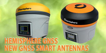
Hemisphere GNSS announced the release of their next-generation, multi-frequency, multi-GNSS S321+ and C321+ GNSS smart antennas. Hemisphere made the announcement at INTERGEO 2017, in Berlin, Germany.
Robust and reliable
Powered by the Eclipse P326 OEM board, the smart antennas support 394 channels. They can simultaneously track all satellite signals, including: GPS, GLONASS, BeiDou, Galileo, and QZSS. This powerful set of features makes them robust and reliable.
S321+ and C321+ come standard with two long-life lithium batteries providing up to 12 hours of operation. The batteries are hot-swappable so operators can change them without stopping work, maximizing efficiency and ROI.
The S321+ and C321+ combine Hemisphere’s Athena GNSS engine and Atlas L-band correction technologies with a new webUI. These smart antennas offer an unparalleled level of customer-friendly performance.
Designed for the most challenging environments, these ruggedized antennas meet IP67-standard requirements. The S321+ and C321+ come in two versions, with 4G LTE optimized for either North American or international locations.
Centimeter-level RTK
Powered by Athena GNSS engine, the S321+ and C321+ provide best-in-class, centimeter-level RTK. Athena excels in virtually every environment where high-accuracy GNSS receivers are in use.
Tested and proven, Athena’s performance with long baselines, in open-sky environments, under heavy canopy, and in geographic locations experiencing significant scintillation is nothing short of cutting edge.
“The S321+ and C321+ represent the advanced technology, durability, and ease of use that our customers have come to expect,” said Miles Ware, Director of Marketing at Hemisphere GNSS. “By upgrading these systems with increased functionality and management capabilities, we are offering unbeatable value to the industry.”
Atlas GNSS Global Corrections
The S321+ and C321+ ship pre-configured to test-drive corrections from Hemisphere’s Atlas L-band correction service. The bundled solution provides users worldwide with an easy way to utilize Atlas, including Hemisphere’s Atlas H10 service offering 8 cm 95% accuracy (4 cm RMS).
They also use Hemisphere’s aRTK
™ technology, powered by Atlas. This allows the receivers to operate with RTK accuracies when RTK corrections fail. If the S321+ and C321+ are Atlas-subscribed, they operate at the subscribed service level until RTK is restored.
The S321+ is the ideal positioning system for applications such as land or marine survey, GIS, mapping, and construction. Together with SureFix
™, Hemisphere’s advanced processor, the S321+ delivers high-fidelity RTK quality information that results in guaranteed precision with virtually 100% reliability.
Designed specifically for construction environments, the C321+ adds another system component that empowers heavy equipment manufacturers to deliver their own machine control and guidance solutions to their customers. The C321+ can pair with Hemisphere’s recently announced SiteMetrix
™ site management software platform that helps manage all construction jobsite activities, including grade and volume checking.
About Hemisphere GNSS
Hemisphere GNSS is an innovative technology company that designs and manufactures high-precision positioning products and services for use in OEM/ODM, marine, machine control & guidance, agriculture, and L-band correction service markets.
Shop Hemisphere GNSS line of
smart antennas at Unmanned Systems Source.

 The AsteRx-i S combines Septentrio’s compact, multi-frequency multi-constellation GNSS engine with ultralight external industrial grade MEMS based IMU.
 GNSS receiver manufacturer Septentrio recently announced the launch of the next generation AsteRx-i. The announcement occurred at IEEE/ION Position Location and Navigation Symposium in Monterey, US.
The AsteRx-i combines Septentrio’s latest compact, multi-frequency multi-constellation GNSS engine with an external industrial grade MEMS based IMU.
It delivers accurate and reliable GNSS/IMU integrated positioning to the cm-level. It also delivers full 3D attitude at high update rates and low latency.
GNSS receiver manufacturer Septentrio recently announced the launch of the next generation AsteRx-i. The announcement occurred at IEEE/ION Position Location and Navigation Symposium in Monterey, US.
The AsteRx-i combines Septentrio’s latest compact, multi-frequency multi-constellation GNSS engine with an external industrial grade MEMS based IMU.
It delivers accurate and reliable GNSS/IMU integrated positioning to the cm-level. It also delivers full 3D attitude at high update rates and low latency.
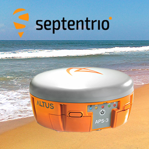 The French navy recently cleared landmines from a beach in Plouhinec, Brittany, France using Septentrio’s APS-3G, highlighting the positioning system's abilities.
Locals had discovered 30 shells in just over a year on Magouëro beach near Plouhinec, on the Western Coast of France. The country's Navy bomb disposal unit stepped in and used the APS-3G to survey the beach and identify the locations of landmines and other World War II objects numbering over 300.
Featuring cutting edge specifications and much more, the APS-3G ensures it is the perfect choice among positioning systems by offering high GNNS performance, high productivity and flexibility.
Any objects that were identified by the APS-3G were either immediately removed or had their positions marked for later removal. The mine's presence on the beach was a result of their use in World War II by the German army to protect their bunkers and a nearby submarine base.
After careful and systematic work, some of the devices found were first buried in the ground then detonated right there on the beach.
Boasting an integrated matching wide band GNSS antenna, the APS-3G is capable of delivering high quality, multi-frequency GPS/GLONASS/Galileo/BeiDou satellite technology simultaneously. The positioning system also features a digital UHF radio and GSM/GPRS.
With a compact and lightweight design, the APS-3G also offers an ease of use that means little training is required before surveyors can use the product. The device can provide reliable and continuous use through its high-capacity Li-Ion batteries that can be quickly swapped during longer periods of use.
Another great advantage of Septentrio’s APS-3G is its ability to adapt to the demands of various field conditions. The machine comes with the option of using either Cellular or UHF transmission and the ability to choose between an RTK Network or the Base-Rover to guarantee maximum uptime.
Other features of note are the 136 channel GPS GPS, GLONASS, GALILEO, & BeiDou Upgrade, integrated Bluetooth capability, and the integrated Digital UHF transceiver that ranges from 406 to 470 MHz. The APS-3G also has a removeable SD card which means surveyors can easily and quickly access the raw data for processing.
But that's not all, the APS-3G has even more innovative features. The device has patented Galileo AltBOC tracking, LOCK+tracking for solid tracking stability under conditions that may involve heavy vibrations, and RTK+ for faster initialization and extended RTK baselines.
The APS-3G is ready to use out of the box and each one comes with two Li-Ion hot swappable batteries, a 2-Bay Battery Charger, a power cable, and a serial cable.
Shop Septentrio's
The French navy recently cleared landmines from a beach in Plouhinec, Brittany, France using Septentrio’s APS-3G, highlighting the positioning system's abilities.
Locals had discovered 30 shells in just over a year on Magouëro beach near Plouhinec, on the Western Coast of France. The country's Navy bomb disposal unit stepped in and used the APS-3G to survey the beach and identify the locations of landmines and other World War II objects numbering over 300.
Featuring cutting edge specifications and much more, the APS-3G ensures it is the perfect choice among positioning systems by offering high GNNS performance, high productivity and flexibility.
Any objects that were identified by the APS-3G were either immediately removed or had their positions marked for later removal. The mine's presence on the beach was a result of their use in World War II by the German army to protect their bunkers and a nearby submarine base.
After careful and systematic work, some of the devices found were first buried in the ground then detonated right there on the beach.
Boasting an integrated matching wide band GNSS antenna, the APS-3G is capable of delivering high quality, multi-frequency GPS/GLONASS/Galileo/BeiDou satellite technology simultaneously. The positioning system also features a digital UHF radio and GSM/GPRS.
With a compact and lightweight design, the APS-3G also offers an ease of use that means little training is required before surveyors can use the product. The device can provide reliable and continuous use through its high-capacity Li-Ion batteries that can be quickly swapped during longer periods of use.
Another great advantage of Septentrio’s APS-3G is its ability to adapt to the demands of various field conditions. The machine comes with the option of using either Cellular or UHF transmission and the ability to choose between an RTK Network or the Base-Rover to guarantee maximum uptime.
Other features of note are the 136 channel GPS GPS, GLONASS, GALILEO, & BeiDou Upgrade, integrated Bluetooth capability, and the integrated Digital UHF transceiver that ranges from 406 to 470 MHz. The APS-3G also has a removeable SD card which means surveyors can easily and quickly access the raw data for processing.
But that's not all, the APS-3G has even more innovative features. The device has patented Galileo AltBOC tracking, LOCK+tracking for solid tracking stability under conditions that may involve heavy vibrations, and RTK+ for faster initialization and extended RTK baselines.
The APS-3G is ready to use out of the box and each one comes with two Li-Ion hot swappable batteries, a 2-Bay Battery Charger, a power cable, and a serial cable.
Shop Septentrio's