
18Jan
Indian Student Develops Landmine-Clearing Drone
Fourteen-year-old Indian student develops a drone designed to clear mines.
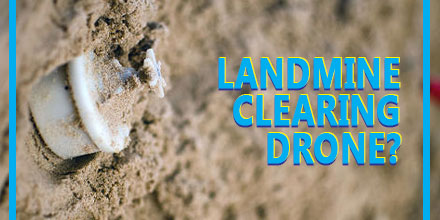 A landmine clearing drone may sound incredible. However, a fourteen-year-old from India has designed a machine that does just that – an anti-landmine drone that can detect and clear landmines.
Harshwardhan Zala found inspiration for his creation while watching news footage.
“I learned that a large number of soldiers succumb to injuries sustained due to landmine blasts while defusing them manually,” Zala said in an interview with the Times of India.
The news report got Zala's mind spinning. In response, Zala designed and constructed a drone to dispose of landmines in a safer manner with less risk to human life.
The first few vehicles were funded by Zala's parents.
“I started making drones on my own and set up an interface with a base station but realized I need to do more,” said Zala. “So I fixed payloads that detect landmines.”
Those small beginnings quickly changed when he won an innovation prize at the L.D. College of Engineering in Gujarat. Soon after, Zala found himself at Google headquarters where he was invited to share his invention with investors.
And most recently, the government of India at the Vibrant Gujarat Summit, granted the designer a contract to produce these drones for use in war zones.
A landmine clearing drone may sound incredible. However, a fourteen-year-old from India has designed a machine that does just that – an anti-landmine drone that can detect and clear landmines.
Harshwardhan Zala found inspiration for his creation while watching news footage.
“I learned that a large number of soldiers succumb to injuries sustained due to landmine blasts while defusing them manually,” Zala said in an interview with the Times of India.
The news report got Zala's mind spinning. In response, Zala designed and constructed a drone to dispose of landmines in a safer manner with less risk to human life.
The first few vehicles were funded by Zala's parents.
“I started making drones on my own and set up an interface with a base station but realized I need to do more,” said Zala. “So I fixed payloads that detect landmines.”
Those small beginnings quickly changed when he won an innovation prize at the L.D. College of Engineering in Gujarat. Soon after, Zala found himself at Google headquarters where he was invited to share his invention with investors.
And most recently, the government of India at the Vibrant Gujarat Summit, granted the designer a contract to produce these drones for use in war zones.
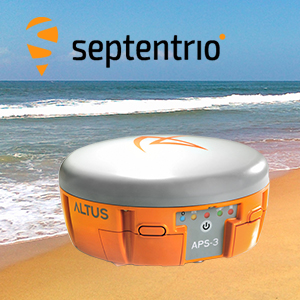 The French navy recently cleared landmines from a beach in Plouhinec, Brittany, France using Septentrio’s APS-3G, highlighting the positioning system's abilities.
Locals had discovered 30 shells in just over a year on Magouëro beach near Plouhinec, on the Western Coast of France. The country's Navy bomb disposal unit stepped in and used the APS-3G to survey the beach and identify the locations of landmines and other World War II objects numbering over 300.
Featuring cutting edge specifications and much more, the APS-3G ensures it is the perfect choice among positioning systems by offering high GNNS performance, high productivity and flexibility.
Any objects that were identified by the APS-3G were either immediately removed or had their positions marked for later removal. The mine's presence on the beach was a result of their use in World War II by the German army to protect their bunkers and a nearby submarine base.
After careful and systematic work, some of the devices found were first buried in the ground then detonated right there on the beach.
Boasting an integrated matching wide band GNSS antenna, the APS-3G is capable of delivering high quality, multi-frequency GPS/GLONASS/Galileo/BeiDou satellite technology simultaneously. The positioning system also features a digital UHF radio and GSM/GPRS.
With a compact and lightweight design, the APS-3G also offers an ease of use that means little training is required before surveyors can use the product. The device can provide reliable and continuous use through its high-capacity Li-Ion batteries that can be quickly swapped during longer periods of use.
Another great advantage of Septentrio’s APS-3G is its ability to adapt to the demands of various field conditions. The machine comes with the option of using either Cellular or UHF transmission and the ability to choose between an RTK Network or the Base-Rover to guarantee maximum uptime.
Other features of note are the 136 channel GPS GPS, GLONASS, GALILEO, & BeiDou Upgrade, integrated Bluetooth capability, and the integrated Digital UHF transceiver that ranges from 406 to 470 MHz. The APS-3G also has a removeable SD card which means surveyors can easily and quickly access the raw data for processing.
But that's not all, the APS-3G has even more innovative features. The device has patented Galileo AltBOC tracking, LOCK+tracking for solid tracking stability under conditions that may involve heavy vibrations, and RTK+ for faster initialization and extended RTK baselines.
The APS-3G is ready to use out of the box and each one comes with two Li-Ion hot swappable batteries, a 2-Bay Battery Charger, a power cable, and a serial cable.
Shop Septentrio's
The French navy recently cleared landmines from a beach in Plouhinec, Brittany, France using Septentrio’s APS-3G, highlighting the positioning system's abilities.
Locals had discovered 30 shells in just over a year on Magouëro beach near Plouhinec, on the Western Coast of France. The country's Navy bomb disposal unit stepped in and used the APS-3G to survey the beach and identify the locations of landmines and other World War II objects numbering over 300.
Featuring cutting edge specifications and much more, the APS-3G ensures it is the perfect choice among positioning systems by offering high GNNS performance, high productivity and flexibility.
Any objects that were identified by the APS-3G were either immediately removed or had their positions marked for later removal. The mine's presence on the beach was a result of their use in World War II by the German army to protect their bunkers and a nearby submarine base.
After careful and systematic work, some of the devices found were first buried in the ground then detonated right there on the beach.
Boasting an integrated matching wide band GNSS antenna, the APS-3G is capable of delivering high quality, multi-frequency GPS/GLONASS/Galileo/BeiDou satellite technology simultaneously. The positioning system also features a digital UHF radio and GSM/GPRS.
With a compact and lightweight design, the APS-3G also offers an ease of use that means little training is required before surveyors can use the product. The device can provide reliable and continuous use through its high-capacity Li-Ion batteries that can be quickly swapped during longer periods of use.
Another great advantage of Septentrio’s APS-3G is its ability to adapt to the demands of various field conditions. The machine comes with the option of using either Cellular or UHF transmission and the ability to choose between an RTK Network or the Base-Rover to guarantee maximum uptime.
Other features of note are the 136 channel GPS GPS, GLONASS, GALILEO, & BeiDou Upgrade, integrated Bluetooth capability, and the integrated Digital UHF transceiver that ranges from 406 to 470 MHz. The APS-3G also has a removeable SD card which means surveyors can easily and quickly access the raw data for processing.
But that's not all, the APS-3G has even more innovative features. The device has patented Galileo AltBOC tracking, LOCK+tracking for solid tracking stability under conditions that may involve heavy vibrations, and RTK+ for faster initialization and extended RTK baselines.
The APS-3G is ready to use out of the box and each one comes with two Li-Ion hot swappable batteries, a 2-Bay Battery Charger, a power cable, and a serial cable.
Shop Septentrio's