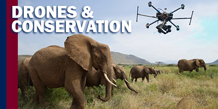
An unlikely contender in the battle for wildlife conservation has entered the ring: drones.
Thanks to an ability to cover large areas at low costs, drones are playing a part in the reduction of wildlife threats.
Globally, drones aid in everything from migration tracking and nest surveys to habitat management and anti-poaching activities.
Drones are changing wildlife conservation around the world.
Drones and Conservation
Since the 1970s, orangutan numbers have decreased sharply. Currently, the International Union for the Conservation of Nature and Natural Resources (IUCN) lists orangutan's as critically endangered.
Today, orangutans face growing threats from poaching and palm oil production across South Asia. Monitoring these animals is now more important than ever.
Conserving the orangutan population effectively requires producing data that is both accurate and timely. Data includes the density, distribution, and land cover change of these animals.
Collecting such data even once was time-consuming and challenging for rangers to acquire via ground surveys. Now, this task is increasingly more efficient with the aid of UAVs.
Today, the Sumatran Orangutan Conservation Program (SOCP) in Indonesia flies drones above the tree canopy. Drones monitor and track endangered populations by observing nests.
Drones, equipped with video cameras, capture high-resolution images that are often too costly to obtain otherwise. Plus, drones can fly pre-programmed missions autonomously for up to 50 minutes and over a distance of 25 km. This helps researchers survey and map forests as well as their biodiversity.
Catching Poachers
South Africa is home to more rhinoceros than any other country, housing 83% of Africa’s rhinos.
Unfortunately, the country also experiences the highest levels of poaching, which is the primary threat to the conservation of the species.
In recent years, poaching deaths increased significantly. The continent’s elephant population declined by 30% from 2007 to 2014. In 2015, poacher's killed at least 1,338 for their horns, threatening the complete extinction of elephants and rhinoceroses.
Past efforts to stop poaching throughout the country have seen little success—until now.
Backed by funding from the World Wildlife Fund, including $5 million from Google, teams are evaluating their ability to combat poachers.
The Air Shepherd Initiative (ASI) group uses analytics to identify poaching areas. Once areas are identified via the algorithm, drones equipped with night vision are sent to track poachers. Once poachers are spotted, rangers are sent to intercept the invaders.
Flying drones up to 15 miles away at night gives ASI critical advantages.
The majority of poachers know that patrols are less effective after dark. Most poaching occurs at night, leaving the parks highly vulnerable once the sun sets. Night vision equipped drones are changing that disadvantage.
Since the program’s launch, ASI completed over 4,000 missions across 3 countries.
Humpback Whales in Antarctica
Traditionally, biologists and zoologists use helicopters, small planes and satellite photography to learn the migration habits of wild animals. However, these methods take a significant amount of time and resources.
“Drones offer a very safe, green, and inexpensive alternative to manned aircraft,” said David Bird, professor of wildlife biology at McGill University.
Significantly smaller and more affordable, drones still capture detailed photographs needed for these efforts. Also, drones can be fitted with thermal cameras and sensors for more accurate monitoring.
Not only do drones utilize less resources, they’re also safer. According to Bird, small plane and helicopter crashes are leading causes of death for wildlife biologists counting animals or surveying nests.
In Antarctica, marine biologists from Duke University use drones along coastlines and nearby seas to monitor the habits of humpback whales.
The team hopes to learn how many whales work together to feed and if roles vary. And the advantage of observing such behavior from above via drone, versus from a boat or from ashore, are numerous.

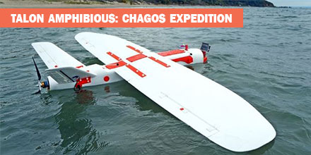 In May 2018, an expedition to the British Indian Ocean Territory launched to study the distribution of megafauna across the Chagos Archipelago. Melissa Schiele, MSc student from Imperial College London, joined the expedition. Schiele also brought an amphibious drone -- the Aeromapper Talon -- to conduct the surveys.
"I was thrilled when Dr. Tom Letessier from Zoological Society of London (ZSL) chose me to help with his drone research as part of the Bertarelli Programme in Marine Science," said Schiele. "Our plan was to survey some of the islands of the Chagos Archipelago to compare distributions of megafauna around islands with nesting birds to islands with invasive rats."
To accomplish this task, Schiele researched possible drones.
"To our knowledge, no one had a fixed-wing water landing drone," said Schiele.
Fortunately for Schiele, there was one such drone that fit the bill -- the amphibious Aeromapper Talon manufactured by Aeromao Inc.
In May 2018, an expedition to the British Indian Ocean Territory launched to study the distribution of megafauna across the Chagos Archipelago. Melissa Schiele, MSc student from Imperial College London, joined the expedition. Schiele also brought an amphibious drone -- the Aeromapper Talon -- to conduct the surveys.
"I was thrilled when Dr. Tom Letessier from Zoological Society of London (ZSL) chose me to help with his drone research as part of the Bertarelli Programme in Marine Science," said Schiele. "Our plan was to survey some of the islands of the Chagos Archipelago to compare distributions of megafauna around islands with nesting birds to islands with invasive rats."
To accomplish this task, Schiele researched possible drones.
"To our knowledge, no one had a fixed-wing water landing drone," said Schiele.
Fortunately for Schiele, there was one such drone that fit the bill -- the amphibious Aeromapper Talon manufactured by Aeromao Inc.