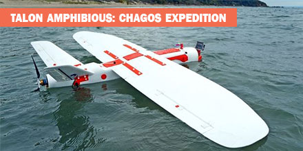
In May 2018, an expedition to the British Indian Ocean Territory launched to study the distribution of megafauna across the Chagos Archipelago. Melissa Schiele, MSc student from Imperial College London, joined the expedition. Schiele also brought an amphibious drone -- the Aeromapper Talon -- to conduct the surveys.
"I was thrilled when Dr. Tom Letessier from Zoological Society of London (ZSL) chose me to help with his drone research as part of the Bertarelli Programme in Marine Science," said Schiele. "Our plan was to survey some of the islands of the Chagos Archipelago to compare distributions of megafauna around islands with nesting birds to islands with invasive rats."
To accomplish this task, Schiele researched possible drones.
"To our knowledge, no one had a fixed-wing water landing drone," said Schiele.
Fortunately for Schiele, there was one such drone that fit the bill -- the
amphibious Aeromapper Talon manufactured by Aeromao Inc.
UAVs and Conservation Efforts
The use of Unmanned Aerial Vehicles (UAV) or drones, is gaining traction in the world of ecology and conservation. In marine environments, scientists are testing the feasibility of drones to locate megafauna as well as map large areas. Initial results are promising across the board.
Many are looking to drones to bridge the gap between ground truthing surveys (diving transects, etc.) and large-scale plane based surveys, which cover thousands of kilometers.
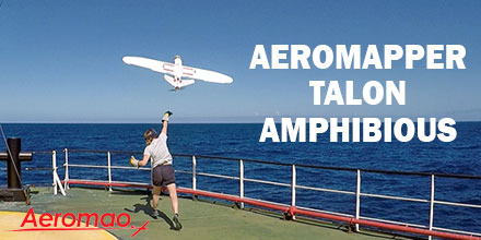
"In April 2018, I flew to Aeromao headquarters in Canada to learn how to fly our new drones. Aeromao created the Talon - a waterproof fixed-wing drone capable of flying huge distances with the strength, stability and mechanisms of a small plane. With a two-meter wingspan, the units looked impressive. After a week of training and a successful water landing on Lake Erie, I packed up the two drones and flew from Toronto to the Maldives."
The Chagos Expedition
"Our first deployment and retrieval of the Talon was a success. Plus, we captured our first aerial footage," said Schiele. "The drones were equipped with two cameras. One was on the belly of the fuselage; it took snapshots every second. The other camera was in the clear nose cone. It allowed live streaming of the drone flight to a screen used by the drone pilot. The images proved our original concept worked and we were able to pin point sharks, birds and large fish."
Overall, the Talon performed well. There were some small water entry points which is being addressed. We also lost a few days to poor weather. For safety reasons, we did not fly in strong winds and there was little sense flying in rain.
By the end of the three-week expedition, we had a suite of images and two drones in need of some TLC.
This expedition is just the beginning of a very exciting, international effort into the use of water landing drones for use in marine ecology. We are learning from any mistakes we make and becoming deft at drone mechanics, too," said Schiele.
About the Aeromapper Talon Amphibious
The Amphibious version of the Aeromapper Talon allows maritime operations by autonomously belly landing on water. Learn more about the
Talon Amphibious and shop the entire line of
Aeromapper UAVs at Unmanned Systems Source.

 The Aeromapper Talon Amphibious by Aeromao is the world's first fixed-wing drone for commercial maritime operations that can belly land on water or parachute down.
With its dual cameras and 20km video link, it’s the perfect solution for observation, data collection and mapping.
The Aeromapper Talon Amphibious by Aeromao is the world's first fixed-wing drone for commercial maritime operations that can belly land on water or parachute down.
With its dual cameras and 20km video link, it’s the perfect solution for observation, data collection and mapping.