News

Aerial Mapping Via Drone

aerial_mapping 
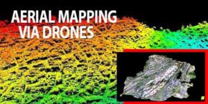
The surveying and mapping industry has used photogrammetry and LiDAR (Light Detection and Ranging) for many years, Questions over which is best have gone on for just as long. Choosing between photogrammetry and LiDAR is not a case of which offers superior technology but, rather, which is better suited for the surveying purposes required. Professionals working in the sector understand that both have their benefits. Photogrammetry uses pictures to take measurements whereas LiDAR uses lasers and light to do the same. For mapping and surveying bare earth regions, photogrammetry is a great choice. But for areas with heavy vegetation or other obstructions in the way of the site being surveyed, LiDAR provides the best fit.

Drone technology takes flight

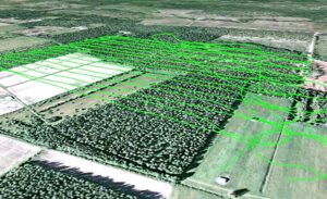
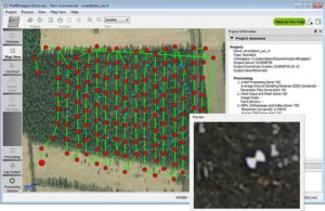
Drone technology has made a huge impact on aerial mapping and surveying. Drones offer many advantages including the ability to capture photos at predefined elevations and at a predetermined overlap percentage. In the past, conventional aerial LiDAR providers turned down surveying projects on areas under 5 square kilometers because it simply wasn't cost effective. Today, drones mounted with LiDAR systems, can map these same areas quickly, affordably and with far less logistical issues. In turn, while drone mounted LiDAR systems achieve great results, their cost and using them over larger areas may not be currently feasible. UAV LiDAR systems also offer image control and perspectives unique from traditional capture methods. Drone operators too have the flexibility to configure the vehicles to gather large volumes of data and capture images that are perfect for what the application requires. The affordability of drones also means that aerial surveying and mapping has attracted more people to the industry. This translates into varying skill and experience levels which inevitably brings about mixed surveying results. In the same way, organizations that rely on surveying data have also decided on an in-house approach.

Acquiring Accurate Imagery

Regardless of whether a surveyor chooses photogrammetry or LiDAR, the ultimate goal is to acquire accurate imagery. Surveyors begin by determining the level of accuracy they require, which drives the decision between LiDAR and photogrammetry. Generally, LiDAR achieves more accurate results but is limited when it comes to obtaining high resolution images through the technology's data. Often, individual use traditional photogrammetry methods to augment the LiDAR data. Surveyors often choose what they are more familiar with, as well as what is more affordable. While there is nothing wrong with such an approach, it is important to keep in mind that the requirements of each project will vary, as will their cost. The use of  UAV LiDAR or photogrammetry alone may work for one project while other missions may require the use of both technologies to achieve the desired imagery. Some surveyors forego LiDAR and photogrammetry entirely, choosing instead photo-based solutions. Though initial costs may be more affordable, redoing everything means expenses can mount quickly.

Varied  Capabilities and Cost

Currently, LiDAR is not as readily available in mainstream technology but options continue to increase.  Still with the right drone and a camera of reasonable quality, surveyors can achieve workable measurements. If a project's requirements are accurately followed, photogrammetry produces accurate 3D models. Its low cost also means it's the most common choice for surveying. Today, even inexperienced operators can capture images to create a 3D demo. However, the quality of the work determines the quality of the data.

Research and due Diligence

When considering LiDAR or photogrammetry, it is important to remember that the choice is not about which is better. Both offer advantages and disadvantages. Limitations presented by technology capabilities, terrain, as well as the size of the area all come into play. Given the choice most surveyors would happily choose both technologies to utilize as they see fit. Those interested in surveying via drone should learn as much as they can about both technologies to determine which works best for their situation.

Fixed Wing or Multi-Rotor?

news_headers_flat  

Should I buy a fixed-wing or a multi-rotor for my application?

At Unmanned Systems Source, we receive calls on a daily basis from customers who ask this very question. We always follow up with a question of our own, “I’m not sure, it depends. What’s your application?”. And so begins a conversation. Choosing between a multi-rotor or a fixed-wing is not always a straight forward choice. In fact, there are a number of factors that should be considered before making a selection. Common questions we ask interested buyers, include: What are the project objectives? How much area needs to be covered? What sort of flight duration is required? Are you collecting data? What is your payload? What is your experience level? And, finally, what is your budget? Once we understand the client’s needs and the operational environment, the choice comes into focus.

Fixed Wing Considerations 7200_c

Fixed-wings are generally better suited for rural environments and are work horses for many commercial and scientific applications. Though they may not offer the maneuverability of a multi-rotor, when it comes to flight times and coverage, fixed wings excel. Other advantages include:
  • Capability of operating at higher altitudes
  • Faster flight speeds
  • Power and capacity to carry heavier and, in some cases, multiple payloads – which in turn means the ability to gather more sophisticated data
  • Option to choose from a wider variety of sensors
  • Extended flight times, 60 minutes +
  • Larger coverage
In regards to the operational area required, it depends on the vehicle. Fixed wings need more space for takeoffs and landings. While hand-launched models deploy quickly, others require a launching rail. The initial costs to purchase a fixed-wing systems are higher but these systems are fairly inexpensive to maintain due to their simpler design. And there is usually less operational “down-time” for fixed-wings.  

M600-1-300x251@2x (1)Multi-rotor Considerations

The use of multi-rotors has exploded in recent years in large part due to their affordability and ease of use. But multi-rotor advantages certainly extend beyond these two points. Other advantages include:
  • Highly maneuverable in flight which is great for urban and tightly confined areas
  • Ability to hover – which make it an excellent choice for inspections of infrastructure that require close-up examination
  • Easy to operate and deploys quickly
  • Small takeoff and landing footprint
  • Affordable price-point
In flight, multi-rotors are incredibly maneuverable and can hover which make them the preferred choice for detailed inspection work and urban areas where space limitations are at a premium. They are also the obvious choice for video and photography work. Though multi-rotors provide only limited flight duration (15-20 minutes on average), their operational flexibility makes it a favored choice for many urban applications. Ultimately, the choice between a multi-rotor or fixed-wing for a specific application depends on a variety of factors. Understanding the strengths and limitations of each vehicle goes a long way in helping inform your decision.

Click here for the Fixed Wing or Multirotor Infographic!

Southwest Antennas Releases World’s Smallest Circularly Polarized Cloverleaf Omni Antennas

SWAIdeal for HD video and high speed data transmission and reception from mobile platforms and offers great improvements to spatial diversity and spatial streaming in MIMO radio systems. Southwest Antennas is pleased to introduce its new small form factor “Turbo Cloverleaf” family of circularly polarized (CP) Omni antennas in 1.98 - 2.2 GHz and 2.3 - 2.5 GHz frequencies. These new and innovative antenna products deliver substantial increases in high data rate throughput and signal-to-noise ratio (SNR) in a very compact, rugged radome that measures less than two inches on any side. Each antenna in the new family of products also features an integrated 3” RF coaxial gooseneck assembly with ruggedized non-rotating RF connector options that allows for flexible antenna mounting and positioning with other closely located equipment or co-located antennas. The new Turbo Cloverleaf antennas were designed with radio users in mind who are in need of the performance that only a Cloverleaf style CP Omni antenna can offer, but in a new compact form factor. The resulting design delivers the world’s smallest cloverleaf style antenna offering robust performance with modern radio systems that are increasingly seeing operation in the wireless broadcast TV / wireless video and live sports markets, UAV / drone video systems, vehicle-mounted radios, and tactical law enforcement and military radios that are utilizing MIMO/MANET system architectures for improved video, voice, and data transmission. “Typical L/S licensed band and 2.4GHz ISM band Cloverleaf antennas currently available on the market have many inherent design flaws that make them ineffective at best for unmanned systems applications and applications requiring two or more co-located antennas” said Benjamin Culver, President, Southwest Antennas. The design and size of this new product line makes it a great options for various applications. “First, the Cloverleaf antennas currently available on the market do not typically have a ruggedized Radome or any Radome at all and they just use exposed wiring to create the antenna cloverleaf radiating element structure that is covered with plastisol or similar insulated coating, leaving the antenna easily susceptible to damage. Second, these antennas measure well over 6” in outside diameter making them impractical for installation on a UAV or drone platform. Third, they have poor and improper impedance matching at the antenna feed point and finally they have poor radiation pattern control over frequency due to inadequate RF choking on the antenna’s cable feed. “The new Southwest Antennas Turbo Cloverleaf antenna design solves all of these challenging design problems by the implementation of the proprietary new Southwest Antennas design approach which reduces the size of the cloverleaf antenna drastically by over 3X in outside diameter without adversely affecting antenna gain or efficiency. The new design uses SMT components inside the Radome located on the antenna element to tune the antenna performance perfectly right at the antenna feedpoint which is a critical factor in the design of high performance cloverleaf antennas. Other proprietary design techniques are used to maintain excellent radiation pattern control over the entire operational frequency band. In short, Southwest Antennas has solved some huge antenna industry problems with the new Turbo Cloverleaf design and we expect this new design to receive industry wide adoption in a large number of diverse applications where status quo Cloverleaf antenna products will just not meet the system requirements”. The proprietary Southwest Antennas Turbo Cloverleaf antenna designs offer over 40dB of isolation between two co-located antennas with opposite CP polarizations which is a significant improvement over two co-located vertical or opposite slant polarized antennas. This new design has shown over 50% improvement in data rate throughputs and over 30% improvements in SNR. These exciting new antenna products are now available for immediate purchase in both Right Hand and Left Hand circular polarizations. Shop now!   About Southwest Antennas Southwest Antennas specializes in the design and manufacture of rugged, high-performance RF and Microwave antennas, accessory products, and customized antenna solutions built for today’s demanding communication environments. Founded in 2005 and headquartered in San Diego, California, Southwest Antennas offers over 1,000 standard products for broadcast video, military / defense, law enforcement, homeland security, surveillance, aerospace, oil and gas, and M2M markets.

Proven cm-level Precision Using UAVs

Septentrio_uavYour challenge, should you choose to accept it… You’ve been asked to survey some points on the ground with centimeter-level accuracy. Feeling confident? How about a few hundred points spread over 7.5 hectares (18.53 acres) and the job has to be done in one afternoon. Throw in the fact that the area you have to survey is in a quarry which has been closed off due to a recent landslide. Still feeling confident? You should and here’s why. Improvements in Unmanned Aerial Vehicle (UAV) technology combined with more compact high-end Global Navigation Satellite Systems (GNSS) receivers means that you no longer have to compromise on precision to measure in those hard-to-reach areas.  

Before the flight

image_uavUAVs have become more reliable and easier to work with: from programming flight paths to installing additional equipment on board, UAV applications are no longer confined to a limited group of specialists. 
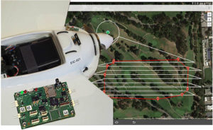
For a survey flight, your UAV will need to have installed: a high-resolution camera and a high-end GNSS receiver module. To fly the UAV through a pre-programmed flight plan, an autopilot flight controller is often included.    

The flight

The flight path shown below covered 7.5 hectares (18.53 acres) and was flown in 15 minutes. The 143 photographs taken during the flight were geotagged with GNSS standalone mode positions. Accuracies in standalone mode are typically around 1 to 4 meters (3.28 to 13.13 ft). If the on-board receiver receives correction information in real time from a nearby GNSS base station, it calculates positions using the more precise (centimeter-level) RTK mode. With the necessary data from a GNSS base station, RTK positioning can also be calculated ‘offline’ in the processing step using GeoTagZ as described below. Offline reprocessing using GeoTagZ removes the need for a real-time data connection between the UAV and base station which simplifies the hardware setup on the UAV and reduces the payload.   flight_path

Back in the office: Geotagging

The AsteRx-m UAS receiver recorded the times the photographs were taken by time-stamping a pulse signal from the camera shutter. It also recorded dual-frequency GNSS measurements during the flight. The GeoTagZ software uses the GNSS data recorded by the receiver and, combining it with the base station reference file, is able to calculate centimeter-level RTK positions for georeferencing the photographs.  The EXIF data of the photographs is then replaced with the more accurate RTK georeferences ready for image processing. In this example, GeoTagZ was able to match images with shutter events despite the receiver file covering a longer time period and so having more events than images.   With the photographs now stamped with a precise time and location, they can be processed. The blue crosses in the screenshot below are the ground locations of check points used to determine the final precision and accuracy. They play no part in the processing. This example details the use of Pix4D and PhotoScan however, other similar image processing tools could equally well have been used.   cropmap

What accuracy can you expect on the ground?

The photographs in this example were processed using two popular image processing software tools Pix4D and PhotoScan from Agisoft. The values highlighted below are the 3D-RMS values from their respective reports. These values are calculated from the sum of squared differences between each of the 20 check points’ surveyed positions and their positions as calculated using the image processing software. The 3D accuracies for both software tools are better than 3.5 cm, with the height (Z) being the largest contributor to the total error. This is the same accuracy that a human surveyor would typically reach when surveying each of the 20 points check points manually.

Pix4D


Agisoft PhotoScan

agisoft

GeoTagZ provides the missing link to centimeter-level ground mapping

The combination of high-resolution aerial photographs with GeoTagZ, for georeferencing with RTK positions from a compact high-end receiver module, provides the complete input for centimeter-level mapping precision on the ground. The same precision as manual survey can thus be achieved in a fraction of the time for all ground points within the surveyed area.

Unmanned Systems to the Rescue

Disasters_T
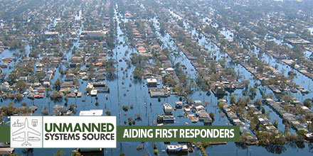
Unmanned advancements help first responder's efforts When disaster strikes we look to the men and women in emergency services to render aid to those affected. Thanks to advances in technology, first responders now have unmanned systems to help in those efforts. Currently, unmanned helpers include Unmanned Aerial Vehicles and robots equipped with sensors, cameras, and even microphones.  

Unmanned Systems impact on an industry

The impact of unmanned technologies in emergency and disaster situations continues to grow. Drones offer numerous advantages including: rapid deployment, the ability to assess dangerous environments from a safe distance, minimize risk to workers, and more. Operators can change drone equipment to adjust to changes in the environment. A night-vision camera can be quickly exchanged for an infrared camera to read heat signatures of survivors. Programmable flight paths ensure complete coverage of an area. All these advantages can significantly impact the number of lives saved in the event of a disaster.  

Extending relief workers’ reach

UAVs are particularly helpful in reaching areas that are inaccessible. Drones equipped with high resolution imagers can provide pictures, stream live video and create before and after snap shots of the affected site. Emergency workers can use this information to determine a plan of action – where to deploy, areas to avoid, identify survivors, and more. What's more, drones can re-deploy to get the most accurate data in what is usually a very active and changing situation. Officials can use the data to continuously adjust and respond accordingly. First responders aren’t the only ones who benefit from drone use in emergency situations. Drone manufacturers can use feedback from operators in the field to improve the overall performance of the product, thus improving capabilities for future relief efforts.  

The challenge of the amateur operator

Unfortunately, the growing use of drones also has a downside. As more enthusiasts take to the skies, they can pose a risk to active emergency situations. Many well-intended users believe they are providing assistance when, in fact, their efforts can hamper and even derail relief efforts. Such situations require formal training, expertise and collaboration with disaster and emergency relief officials. Operators functioning on their own volition are a risk to personnel on the ground. Rescue organizations continue to advise drone enthusiasts, not officially involved in efforts, to restrain themselves and stay away from active emergency situations.  

A growing array of unmanned systems

Rescue personnel can choose from an ever increasing array of unmanned systems. For example, RoboSimian is a highly dexterous robot that can access areas deemed too risky for humans. This robot can scan, assess as well as manipulate its environment. Currently, RoboSimian can close a valve, pick up an object and remove impediments. Certain situations require even more sophisticated technology – such as detecting movement under piles of debris. Developed by NASA’s Jet Propulsion Laboratory, FINDER (Finding Individuals for Disaster and Emergency Response) utilizes low power radar to detect imperceptible movements beneath rubble. FINDER’s radar emits a low power radio signal that bounces off debris and changes if movement is detected. As with robots and UAVs, FINDER is an important tool that enables rescuers to locate those in need and provide assistance quickly and efficiently.  

A bright future

Given the advantages unmanned systems offer, emergency and disaster relief agencies will continue to adopt this technology. For the agencies involved in planning and executing search and rescue operations, the deployment of UAVs, robots and additional technology is a positive development.

Wildfire Operations & Temporary Flight Restrictions

wildfire_T
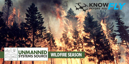
"Know Before You Fly" Urges Operators to Stay Away from Wildfires, Adhere to Temporary Flight Restrictions 

WASHINGTON — The Know Before You Fly campaign today urged operators of unmanned aircraft systems (UAS) to respect temporary flight restrictions (TFRs) over and around wildfires as this year’s wildfire season makes an early start.

Wildfires or other hazardous conditions often lead to authorities putting in place TFRs, which allow first responders to do their jobs unimpeded and without danger to their aerial support.

Temporary Flight Restrictions

Violating the TFR may endanger the safety of the operation, and in some cases may ground search and rescue crews until the airspace is cleared, allowing the wildfire to spread. But TFRS do not just apply to wildfires.

For stadium events ranging from concerts to NASCAR races to the Super Bowl, model aircraft flights and unmanned aircraft operations are generally restricted. More information about the types of TFRs may be found here.

To check for TFRs in your area, visit the FAA TFR list at http://tfr.faa.gov/tfr2/list.html. Additionally, download the FAA’s B4UFLY app, available on the App Store or Google Play, to find up-to-date information on TFRs.

No one should be flying within a TFR that restricts UAS and/or model aircraft operations.

Standard flight guidelines for operators

At all other times when flight is permitted, Know Before You Fly would like to remind recreational flyers to follow these guidelines to keep the skies safe for all:

  • Fly no higher than 400 feet
  • Fly within visual line of sight
  • Stay well clear of other aircraft
  • Never fly within 5 miles of an airport without contacting airport authorities or air traffic control
  • Keep well away from emergency response efforts, such as fires
  • Beware of FAA airspace requirements (http://www.faa.gov/uas/tfr/)
  • Don’t fly under the influence
  • Register your device before your first flight (http://knowbeforeyoufly.org/register-your-drone/)

If you are flying for commercial purposes, please adhere to the FAA small UAS regulations, which can be found here.

Know Before You Fly was launched by the Association for Unmanned Vehicle Systems International (AUVSI) and the Academy of Model Aeronautics (AMA) in partnership with the FAA with the goal of spreading awareness about safe and responsible use of UAS. For more information on safe and responsible flying, visit KnowBeforeYouFly.org or follow @FlyResponsibly on Twitter.