
LiDAR Sensors and INS Data
A reliable and accurate GNSS-INS sensor is a crucial element for gyro stabilization of cameras, LiDAR georeferencing and antenna tracking.
Recently, Livox Technology Company -- an independent company founded in 2016 through DJI's Open Innovation Program -- reached out to Inertial Sense.
Livox was in need of an efficient, affordable and complete INS solution to help with their aerial mapping task. Inertial Sense was ready.
Their solution? The Inertial Sense µINS – GNSS aided Inertial Navigation System.
The Inertial Sense µINS is a miniature, GNSS aided Inertial Navigation System (GNSS-INS) module. It includes all the functionality of the µAHRS and provides orientation, velocity, and position.
Users can apply RTK Base station correction data to achieve CM level precision. Sensor data from MEMs gyros, accelerometers, magnetometers, barometric pressure, and GNSS fuse for an optimal estimation.
Livox LiDAR
Currently, Livox sensor's are in use for automotive, robotics and surveying 3D Mapping Applications.
Livox offers a line of advanced sensor units. As such, companies and developers have a reliable route to incorporate this technology into survey projects and autonomous vehicle platforms.
Livox sensors’ performance, affordability, and reliability enable it for use in autonomous driving, robotics and UAV surveying and mapping.
Livox MID-40 LiDAR sensor and Inertial Sensor INS are in use in harsh environments where there are vibrations from the aerial craft. Vibrations often create big problems for most Inertial Measurement Units.
LiDAR Sensors and INS Data
INS and GNSS are necessary to compensate for LiDAR movement -- both rotation and translation -- during drone flight.
As the UAS flies, motion is inevitable due to air turbulence, propeller motion and other external and internal forces.
By incorporating data from an INS, it is possible to measure all LiDAR movements. This includes vibration which is required for sensor fusion and mapping.
Flying with the companion INS separates the payload from the drone. Plus, it allows Livox customers the flexibility to choose any drone platform.
To keep the cost of the survey application down, Livox integrated the tight angular accuracy INS sensors from Inertial Sense.
By using an external INS from Inertial Sense, Livox combined and synced data.
To achieve the finest detail aerial mapping, the rotation and translation measured by the INS sensor and matched to the LiDAR data needed to be accurate to the centimeter.
Development and Integration
To start the development and integration, Livox selected the µINS development kit.
The development kits include the selected module, antennas and appropriate cables to connect to the system. Plus, it includes technical support for system integration.
Main technical characteristics: up to 1KHz IMU, 500Hz INS Update Rate; measurement range of angular resolution 0.1 degrees roll/pitch, GNSS update rate is 5Hz, power voltage 3.3 V; overall dimensions: 35.9 x 25.4 x 11.2mm, weight 10.5g.
Improved Accuracy
The end result was impressive.
Livox LiDARs paired with Inertial Sensor’s miniature, low-cost, GNSS aided Inertial Navigation System (GNSS-INS) module made aerial mapping more efficient and affordable than ever.
INS advanced algorithms provided output from MEMs inertial sensors, magnetometers, barometric pressure, and high-sensitivity GNSS receivers with centimeter accuracy to obtain fast, accurate, and reliable attitude, velocity, and position data during aerial mapping.
With accurate INS data (position and pose) from the sensors, Livox improved final data point accuracy.
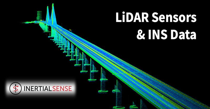
Livox projected all data points to an Earth frame to build a global map. As a result, the team accurately mapped the entire 3km-long Huizhou Bay Bridge, located in Guangdong, China...down to its finest details.
Shop Inertial Sense's entire line of INS solutions at Unmanned Systems Source.
About Inertial Sense
Inertial Sense is a premier provider of robust micro inertial navigation solutions for autonomous application manufacturers.
 The surveying and mapping industry has used photogrammetry and LiDAR (Light Detection and Ranging) for many years, Questions over which is best have gone on for just as long.
Choosing between photogrammetry and LiDAR is not a case of which offers superior technology but, rather, which is better suited for the surveying purposes required. Professionals working in the sector understand that both have their benefits.
Photogrammetry uses pictures to take measurements whereas LiDAR uses lasers and light to do the same. For mapping and surveying bare earth regions, photogrammetry is a great choice. But for areas with heavy vegetation or other obstructions in the way of the site being surveyed, LiDAR provides the best fit.
The surveying and mapping industry has used photogrammetry and LiDAR (Light Detection and Ranging) for many years, Questions over which is best have gone on for just as long.
Choosing between photogrammetry and LiDAR is not a case of which offers superior technology but, rather, which is better suited for the surveying purposes required. Professionals working in the sector understand that both have their benefits.
Photogrammetry uses pictures to take measurements whereas LiDAR uses lasers and light to do the same. For mapping and surveying bare earth regions, photogrammetry is a great choice. But for areas with heavy vegetation or other obstructions in the way of the site being surveyed, LiDAR provides the best fit.