 High-precision GPS receivers mounted on drones able to identify 1mm hairline defects in cooling towers
How do you inspect a structure that’s almost 160 m high and 120 m in diameter? With a few weeks to spare, a crash course in abseiling and a head for heights, a person could certainly give it a go.
Imagine, however, that you need to collect enough data for a 3D model with the precision of 1 mm…all within a week.
This was the challenge facing Aetos Drones. The company was tasked with inspecting a cooling tower at Tihange Nuclear Power Station near Liege in Belgium.
The three reactors at the Tihange Power Station came online between 1975 and 1985. This makes the oldest of the three over 40 years old. Cooling towers built in this era have a life expectancy of 15-20 years. But, with careful maintenance, the lifetime can extend a further 20 years.
The Tihange reactors contribute about 25% of all electricity generated in Belgium. The plan is to decommission the towers in 2025. Until then, the cooling towers need to be kept in good working order.
Fortunately, drones equipped with highly precise and reliable GPS receivers can help.
Pressurized Water Reactors, such as at Tihange, have cooling towers. These towers supply cold water to the condenser which works to cool the steam back into water. The steam drives the electricity-generating turbines.
Cooling towers are elegantly simple in their operation. Warm water from the condenser sprays into the tower through a network of sprinklers, warming the surrounding air and causing it to rise. This in turn draws cooler air in through openings in the base of the tower maintaining a constant, natural draft of cool air through the tower.
Corrosion is a possibility in any system where water plays a part.
Cooling towers are hollow, thin-walled structures made from reinforced concrete. Over time, the humid environment can corrode the metal elements of the tower. In every cycle through the cooling tower, about 2% of the water evaporates forming the characteristic steam clouds. This increases the salt concentration in the remaining water which increases its corrosive power.
In addition, high winds and winter icing can also cause damage and weaken the cooling tower.
Aetos Drones, were called in to carry out the inspections. And, Belgian’s first certified drone pilot, Lieve Van Gijsel, took the helm.
An octocopter fitted with a high-resolution camera, a RADAR system and an AsteRx-m UAS receiver conducted the inspection. The air vehicle took photographs at regular intervals as it traveled vertically up and down the sides of the cooling tower.
The RADAR system was AIRobot’s Ranger, an add-on sensor specifically designed for distance detection on UAVs. The octocopter needed to get close enough to get quality images. However, the octocopter needed to maintain enough distance so as not to risk getting tossed around by the turbulence generated by the tower.
Over the course of 4 days, more than 19,000 photographs of the cooling tower were taken.
During the flight, the AsteRx-m UAS receiver logged GNSS measurements and the exact time each photograph was taken.
After the flight, these shutter times and GNSS measurements were combined with GNSS measurements from a nearby base station using Septentrio’s GeoTagZ software. As such, each photograph was stamped with the cm-level precise RTK position of the camera – the ideal input for the next processing stage.
After processing with GeoTagZ, the photographs were then uploaded to the photogrammetry software Agisoft PhotoScan. Over the course of several days, the photographs were stitched together to produce a highly-detailed 3D model of the cooling tower, precise to the level of 1 mm. Experts at Tihange then analyzed the surface of the cooling tower down to any required level of detail.
3D inspection models with 1 mm resolution are made possible using high-quality, multi-frequency GNSS measurements from high-end receivers like the AsteRx-m.
Not only does the positioning have to be precise, it has to be reliable. This requires: accurate error models, continuous tracking during mechanical jolts and advanced satellite integrity monitoring (RAIM).
For large-structure inspections, such as this, multi-constellation positioning is essential to ensure there are always enough satellites available to work with. The receiver will also need a good multipath mitigation filter (APME) to disentangle direct and reflected satellite signals to avoid jumps in the calculated position.
The AsteRx-m UAS established itself as the receiver of choice for UAV applications requiring high-precision positioning. With the recent release of the AsteRx-m2 UAS, drone inspections can take on applications at an entirely new level of difficulty.
The AsteRx-m2 UAS adds BeiDou and Galileo as well as L5 frequency tracking. It also includes the AIM+ interference mitigation system. The additional constellations allow operation in areas where overhead structures limit the scope of single and dual-constellation receivers.
Shop Septentrio’s line of high accuracy receivers at Unmanned Systems Source.
 Affordable, high-end drones coupled with easy-to-use mission-planning tools, created the perfect environment for drones to flourish.
No longer the preserve of specialists, applications using drones have ventured into survey, inspection and volume analysis.
The impact of drones is little short of revolutionary.
But, in the air, the stakes are higher. When things go wrong, the consequences are invariably much more serious than for a ground-based application. One of the biggest threats to drone safety is GNSS interference.
At the very least, disruptions to satellite signals can degrade position quality. When this occurs it causes fall-backs from high-precision RTK and PPP modes to less-precise modes. In the most extreme cases, interference can result in complete loss of signal tracking and positioning.
Other components installed on a UAV is often a significant source of interference. The restricted space often means that the GNSS antenna is in close proximity to other electrical and electronic systems.
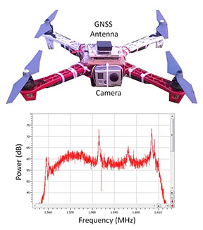 Figure 1 shows what happened to the GPS L1-band spectrum when a GoPro camera was installed on a quadcopter close to the GNSS antenna without sufficient shielding. The three peaks are exactly 24 MHz apart. This points to their being harmonics of a 24 MHz signal: the typical frequency for a MMC/SD logging interface.
An AsteRx4 receiver, which includes the AIM+ system, was selected for this setup. As well as mitigating the effects of interference, AIM+ includes a spectrum plot to view the RF input from the antenna in both time and frequency domains.
At the installation stage, the ability to view the RF spectrum is an invaluable tool for identifying the source of interference. Plus, it helps with determining the effectiveness of measures such as modifying the setup or adding shielding.
For the quadcopter installation in this example, the loss of RTK was readily diagnosed. The problem was solved by placing the camera in a shielded case. All this while the quadcopter was still in the workshop.
GNSS receivers on-board UAVs can be particularly vulnerable to external sources of interference, be they intentional or not. In the sky, the signals from jammers can propagate over far longer distances than they would on land.
In the case of UAV inspections of wind turbines for example, many countries encourage the construction of windmills next to roads. However, this situation increases the chance of interference from in-car chirp jammers.
Though illegal, chirp devices are cheap and readily available on the internet. For example, an individual using a chirp jammer can drive around undetected by the GPS trackers on the vehicle. Car thieves can disable GPS anti-theft devices on stolen vehicles with chirp jammers.
Although transmitting with a power of around 10 mW, chirp jammers are powerful enough to knock out GNSS signals in a radius of several hundred meters on land. In the air, unhindered by trees, building or other obstacles, these jamming signals have a far greater reach. Thus, the UAV is much more vulnerable to interference.
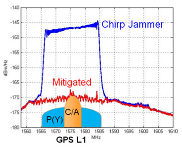
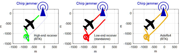 Figure 2 shows how a 10mW chirp jammer can knock out RTK positioning over more than 1 km in a high-end receiver.
Even a low-end consumer-grade L1 receiver, being less accurate and thus less sensitive, loses stand-alone positioning over several hundred meters.
With AIM+ activated, the AsteRx4 is able to maintain an RTK fix throughout the simulated flight. It also shows no degradation to its position variance.
A comprehensive approach puts interference considerations at the forefront of receiver design and incorporates it into every stage of signal processing. In the case of the AsteRx4 and AsteRx-m2, the antenna signal is immediately digitized after analogue filtering and automatically cleansed of interference using multiple adaptive filtering stages.
As each interfering signal has its own individual footprint, the ability to visualize the RF signal in both time and frequency domains allows drone users to identify sources of self-jamming and adapt their designs accordingly before the drone gets in the air.
When it is in the air, AIM+ is able to mitigate jamming from external sources: a set of configurable notch filters are complemented by an adaptive wide-band filter capable of rejecting more complex types of interference such as that from chirp jammers, frequency-hopping signals from DME/TACAN devices as well as high-powered Inmarsat transmitters.
You can shop Septentrio’s line of solutions at Unmanned Systems Source.
 May 8, 2017 – Septentrio, a leading manufacturer of accurate and reliable GNSS solutions, announced the release of the AsteRx-m2 and AsteRx-m2 UAS OEM boards.
These OEM boards bring the latest in GNSS positioning to the market with unmatched interference mitigation technology all on ultra-low-power.
Septentrio will showcase these OEM boards in Dallas, Texas at AUVSI’s Xponential 2017.
The credit-card sized AsteRx-m2 and the AsteRx-m2 UAS offer all-in-view multi-frequency, multi-constellation tracking and centimeter-level RTK position accuracy for the lowest power of any comparable receiver. Additionally, the AsteRx-m2 and the AsteRx-m2 UAS can receive TerraStar satellite-based correction signals for PPP positioning.
Also, both boards feature Septentrio’s AIM+ interference mitigation system: the most advanced on-board interference mitigation technology on the market. It can suppress the widest variety of interferers, from simple continuous narrowband signals to wideband and pulsed jammers.
Increased levels of radio frequency pollution coupled with the intrinsic danger of self-interference in compact systems such as UAS, makes interference mitigation vital to any UAS GNSS system.
The AsteRx-m2 UAS is designed specifically for unmanned systems. It brings plug-and-play compatibility for autopilot software such as ArduPilot and Pixhawk. And event markers can accurately synchronize a camera shutter with GNSS time.
In addition, the board can receive power directly from the vehicle power bus via its wide-range power input. The AsteRx-m2 UAS works seamlessly with GeoTagZ software and its SDK library for RPK (ReProcessed Kinematic) offline processing to provide RTK accuracy without the need for ground control points or a real-time datalink.
“The market demands increasingly accurate and reliable GNSS positioning systems for inspection, mapping and aerial survey” stated Gustavo Lopez, Product Manager at Septentrio. “Septentrio’s answer is the AsteRx-m2 and the AsteRx-m2 UAS. They offer multi-frequency and multi-constellation tracking as well as robust interference protection all for the lowest power on the market.”
If attending XPONENTIAL, find out more about the AsteRx-m2 UAS by stopping by Septentrio’s booth, #749, or Unmanned Systems Source at booth #325.
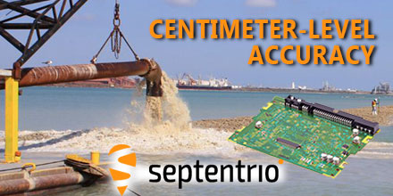
Septentrio designs, manufactures and sells high-precision multi frequency multi constellation GPS/GNSS equipment. Receivers, designed by Septentrio, deliver consistently accurate GNSS positions scalable to centimeter-level. They perform solidly even under heavy scintillation or jamming. Receivers are available as OEM boards, housed receivers and smart antennas.
Shop Septentrio’s line of GNSS receiver solutions at Unmanned Systems Source.
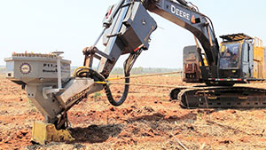
 GPS receivers can assist operators in making better decisions by providing precise position information (indicate-only mode). Or the GPS receiver, as part of a guidance system, can take over the operation of the machine’s implement itself (fully-automatic mode) to follow a preloaded design.
In fully-automatic mode, the RTK centimeter-level precision of the GPS guidance system is far more accurate and consistent than relying on the operator’s skill alone.
Trenches are dug to exact depths, tractors are steered in perfect rows, piling rigs know the precise location for planting piles and surfaces are fine graded the first time. Work is completed quicker, more cheaply and to a higher specification when the need to carry out frequent measurements and surveys is not needed.
Compared to a Total Station, a GPS RTK system setup is quick and doesn’t require any of the elements to be in line of sight. A single reference base station can furnish all rover machines on-site continuously with RTK differential corrections. The status of the project and location of every machine on-site is updated in real-time giving site managers a full overview of progress.
Machine control applications are among the most challenging for GPS receivers. The physical and radio environments can be difficult enough but operators will always try to push their equipment to its limits. So what GPS receiver capabilities are needed for consideration as a suitable candidate for machine control? There are six prime considerations.
In RTK mode, using a base station that’s not too far away, high-end GPS receivers calculate position with a precision of less than 1 centimeter (0.4 inch). Difficult conditions can degrade the position precision and can even result in wrong position fixes.
Construction sites present their own set of challenges. Large structures and other machines nearby can cause multi-path. Foliage can be particularly problematic for GPS signal quality. And operators can’t always be assured of a clear view of the sky.
Any GPS receiver worth its salt should be adeptly manage the typical conditions on a building site. The consequences of a wrong position fix can be costly and time consuming. A piling operator needs the exact position and orientation of the rig to plant a pile. After all, there are far better ways to spend time than extracting wrongly-placed piles.
Latency is the time it takes for the receiver to calculate and output a position. Lower latencies and higher position update rates provide more responsive machines that operate at higher speeds without loss of performance.
The highest performing GPS receivers today can output data at upwards of 50 Hz with latencies of less than 20 ms.
A delivery vehicle arriving on-site with a chirp jammer can knock out RTK and bring operations to a standstill. The prevalence of such devices, as well as interference from other non-intentional sources continues to increase. Interference mitigation is now an essential tool for a machine control receiver.
Today’s highest performing GPS receivers can mitigate against simple continuous narrow-band and pulsed interferers as well as more complex wide-band transmitters such as chirp jammers and other PPDs (Personal Privacy Devices).
Machines such as excavators have a platform that rotates independently of the undercarriage. To know the position of the bucket, the operators must also know the orientation (or heading) of the platform. Depending on placement, two antennas allow the GPS receiver to calculate the heading of the platform as well as either the pitch or the roll.
Rough terrain can play havoc with GPS signal tracking. Without an adaptive-bandwidth tracking-loop mechanism, the receiver may lose tracking during periods of heavy vibration.
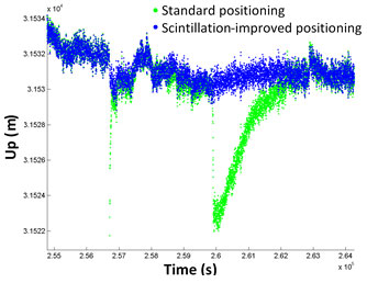
We’re currently winding down from the last solar-activity peak in 2014. However, ionospheric disturbance of GPS signals are still problematic around the equator and at higher latitudes. Ionospheric scintillation mitigation ensures GPS output remains predictable and that RTK positioning is maintained.
Today, a wide variety of applications use GPS receivers. From seismic monitoring and timing to on-board dredgers and drones, GPS receivers provide high-precision positioning or timing when needed.
If your applications requires this level of precision, make sure you check out Septentrio’s line of solutions at Unmanned Systems Source.
 February 13, 2017 – Septentrio GNSS technology continues to provide solutions for challenging situations.
Case in point? The Belgian dredging, environmental and engineering group DEME. They rely on the accuracy and reliability of the AsteRx family of precise GNSS positioning solutions from Septentrio.
DEME is using Septentrio’s AsteRx GNSS receivers to obtain centimeter-level accuracy for all their dredging and marine construction operations worldwide.
These receivers are designed to operate in difficult conditions. From ice-covered Arctic ports to the tropical climates of Southeast Asia; whether dredging a few meters from the coast line to constructing wind turbines kilometers out at sea.
DEME began using Septentrio’s solutions over 10 years ago. While dredging in the Belgian town of Oostende, DEME couldn’t obtain a reliable RTK position from their GNSS equipment. The problem? Interfering radio signals from a local radio tower. Septentrio worked with DEME to identify the source of the interference. Once the problem was discovered they modified a standard RTK receiver with special firmware to address the jamming problem.
This case, along with others faced by Septentrio’s customers in the field, began development of a dedicated interference mitigation technology called AIM+ which is now standard in Septentrio’s GNSS solutions.
Septentrio’s AsteRx GNSS receivers are deployed on DEME’s ships around the world. They have been vital to DEME for the success of projects such as the creation of Gateway Port in London, UK; the construction of Deurganckdock, Antwerp, Belgium; the
Pearl Qatar City; Thornton Bank Offshore Windfarm, Belgium, extension of the Suez Canal, Egypt and many more.
“’Creating land for the future’ is the slogan here at DEME and this is thanks in part to the accuracy and robustness of the solutions offered by Septentrio” stated Lorentz Lievens, Head of Survey Department.
“Jamming is a concern which DEME has seen more and more all over the world. Septentrio’s receivers are unique in that they continue to provide an accurate solution even in areas of high radio and ionospheric interference allowing DEME to deliver projects on time and on budget,” continued Lievens.
Septentrio’s precise positioning solutions will remain vital for DEME to deliver quality and cost-effective operations around the world for many years to come.”
Septentrio designs, manufactures and sells high-precision multi-frequency multi-constellation GPS/GNSS equipment, which is used in demanding applications in a variety of industries such as marine, construction, agriculture, survey and mapping, geographic information systems (GIS), and unmanned aerial vehicles (UAVs) as well as other industries. Their receivers deliver consistently accurate GNSS positions scalable to centimetre-level, and perform solidly even under heavy scintillation or jamming. Receivers are available as OEM boards, housed receivers and smart antennas.
Unmanned Systems Source is pleased to partner with Septentrio. Shop Septentrio’s product line to find the solution that is right for your application.
 Your challenge, should you choose to accept it…
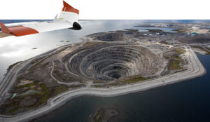
You’ve been asked to survey some points on the ground with centimeter-level accuracy. Feeling confident?
How about a few hundred points spread over 7.5 hectares (18.53 acres) and the job has to be done in one afternoon. Throw in the fact that the area you have to survey is in a quarry which has been closed off due to a recent landslide. Still feeling confident?
You should and here’s why.
Improvements in Unmanned Aerial Vehicle (UAV) technology combined with more compact high-end Global Navigation Satellite Systems (GNSS) receivers means that you no longer have to compromise on precision to measure in those hard-to-reach areas.
 UAVs have become more reliable and easier to work with: from programming flight paths to installing additional equipment on board, UAV applications are no longer confined to a limited group of specialists.
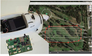
For a survey flight, your UAV will need to have installed: a high-resolution camera and a high-end GNSS receiver module. To fly the UAV through a pre-programmed flight plan, an autopilot flight controller is often included.
The flight path shown below covered 7.5 hectares (18.53 acres) and was flown in 15 minutes. The 143 photographs taken during the flight were geotagged with GNSS standalone mode positions. Accuracies in standalone mode are typically around 1 to 4 meters (3.28 to 13.13 ft).
If the on-board receiver receives correction information in real time from a nearby GNSS base station, it calculates positions using the more precise (centimeter-level) RTK mode.
With the necessary data from a GNSS base station, RTK positioning can also be calculated ‘offline’ in the processing step using GeoTagZ as described below. Offline reprocessing using GeoTagZ removes the need for a real-time data connection between the UAV and base station which simplifies the hardware setup on the UAV and reduces the payload.
The AsteRx-m UAS receiver recorded the times the photographs were taken by time-stamping a pulse signal from the camera shutter. It also recorded dual-frequency GNSS measurements during the flight.
The GeoTagZ software uses the GNSS data recorded by the receiver and, combining it with the base station reference file, is able to calculate centimeter-level RTK positions for georeferencing the photographs. The EXIF data of the photographs is then replaced with the more accurate RTK georeferences ready for image processing.
In this example, GeoTagZ was able to match images with shutter events despite the receiver file covering a longer time period and so having more events than images.
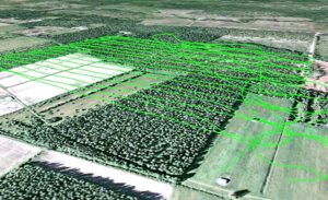
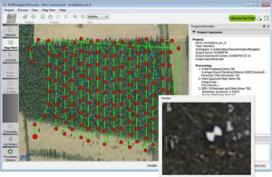
With the photographs now stamped with a precise time and location, they can be processed. The blue crosses in the screenshot below are the ground locations of check points used to determine the final precision and accuracy. They play no part in the processing.
This example details the use of Pix4D and PhotoScan however, other similar image processing tools could equally well have been used.
The photographs in this example were processed using two popular image processing software tools Pix4D and PhotoScan from Agisoft. The values highlighted below are the 3D-RMS values from their respective reports. These values are calculated from the sum of squared differences between each of the 20 check points’ surveyed positions and their positions as calculated using the image processing software.
The 3D accuracies for both software tools are better than 3.5 cm, with the height (Z) being the largest contributor to the total error. This is the same accuracy that a human surveyor would typically reach when surveying each of the 20 points check points manually.
![]()
![]()
The combination of high-resolution aerial photographs with GeoTagZ, for georeferencing with RTK positions from a compact high-end receiver module, provides the complete input for centimeter-level mapping precision on the ground. The same precision as manual survey can thus be achieved in a fraction of the time for all ground points within the surveyed area.
