 We know more about the universe than we do about the oceans.
As such, it is no surprise that researchers are looking for new ways to understand the ocean.
Of particular interest is the sea surface microlayer (SML) which is identified as the top 1 millimeter of the ocean surface.
The SML is where all gas exchange between the atmosphere and the ocean occurs. However, the processes that control carbon dioxide transport and transformation in oceans remain largely unknown.
To better understand the overall health of the ocean, scientists need to model the transfer of gases between the atmosphere and the ocean. Such a model would allow for the creation of regional and global budgets of carbon, nutrients and pollutants.
When waves break on the surface of the ocean, mixing occurs. This allows gas from the atmosphere to enter the water and water from the ocean to enter the atmosphere.
Scientists know a lot about mixing at wind speeds between 6 and 30 knots. However, there is still much to discover at lower speeds.
The SML is an oily film which is more prevalent when the water is calm. In flat water conditions it is fair to suspect that the micro-layer suppresses waves and decreases mixing.
This is why the science team on the R/V Falkor journeyed to the flat water conditions found off the coast of Darwin, Australia.
One reason so little is known about the SML is that the mere presence of the boat disturbs the microlayer, making it nearly impossible to get accurate, untainted data.
Studying this microlayer entails a few challenges. Research vessels must travel far out into the ocean to find flat water conditions. And, once there, the research equipment must operate away from the boat to get undisturbed Microlayer data.
So, how does a researcher collect ample undisturbed SML data and not blow the budget?
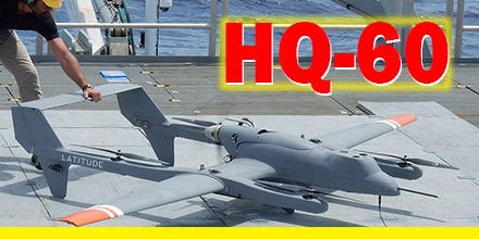
Enter Latitude and the HQ-60’s real-world-tested VTOL capabilities.
Based on previous work with NOAA and the R/V Oscar Elton Sette off the coast of Hawaii, the Latitude team was up to the task.
The unique design of the HQ-60 enables vertical take off and landing. Thus, the small footprint of the R/V Falkor was not an issue.
Furthermore, HQ-60 operators programmed the vehicle to perform a specific flight pattern at various elevations. This program ensured that the vehicle could replicate the pattern as often as needed.
The HQ-60’s maximum payload capacity of 20 lbs. put the researcher’s skills to the test. However, three years of effort culminated in a custom design which fit into the HQ-60’s payload bay.
Researchers selected Hyperspectral cameras to record varying colors of the water in high wavelength resolution.
By correlating ocean colors with the chemical and biological composition of the samples, the team linked oceanic processes with the color spectrum of seawater.
With this information, researchers can use satellite imagery to calibrate ocean color and connect them to specific biochemical processes.
The HQ-60, can map vast ocean areas with no disturbance. Plus, the HQ-60 performed these operations at very little cost and at unprecedented speed, rate and efficiency.
The team prepped the HQ-60 and, using its VTOL systems, launched from a 40 foot by 40 foot area.
Once it autonomously transitioned to forward flight, the aircraft remained near the ship as system functionality
Upon completion of the system check, the aircraft traveled up to 6 miles away to take readings of the SML over undisturbed water. Typically, data collection operations lasted 3 hours.
Once completed, the aircraft traveled back to the ship, completed a final systems check and landed on the deck of the Falkor.
The unique design of the HQ-60 — with its compact size, payload capacity and flight endurance — makes it a reliable solution for a variety of missions.
Find out more about Latitude Engineering’s HQ-40 and HQ-60 at Unmanned Systems Source.
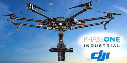 Recently, Phase One Industrial announced full integration of its iXU and iXU-RS aerial cameras with DJI’s M600 and M600 Pro drones.
Phase One Industrial was the first to deliver 100-megapixel medium format aerial cameras.
Built using DJI’s SDK, this is the latest drone platform supported by Phase One Industrial.
From photogrammetry to critical infrastructure monitoring, Phase One continues to innovate inspection tools capable of addressing diverse aerial imaging applications.
The integration with DJI’s M600 and M600 Pro platforms is already delivering high quality results.
“The Phase One Industrial IXU camera with the DJI M600 drone, delivered extraordinary results,” said UAV Flight Systems Manager Tobias Wentzler, Lufthansa Aerial Services. “We achieved millimeter per pixel accuracy. This allowed us to inspect in exquisite detail and lift our mission results and accuracy to a new, high-end level. We identified the subtlest cracks or imperfections that were not visible to conventional inspection methods.”
Phase One Industrial’s continuous efforts to identify and develop aerial imaging solutions meet the exacting needs of aerial imaging professionals in diverse markets.
“When our clients hire us, they expect the best,” said Ron Chapple, CEO of Aerial Filmworks. “With the new Phase One Industrial aerial cameras integrated with DJI drones, Aerial Filmworks can deliver the robust performance, highest resolution and finest image quality to support our clients’ cinematic projects.
“GEO1, the survey division of Aerial Filmworks, a solutions-driven provider in the electric and gas/oil marketplace, also benefits from this development. Now, we have the right solution to help satisfy our clients’ requirements for the high resolution data and flight efficiencies.”
Phase One Industrial iXU and iXU-RS aerial cameras’ integration with DJI M600 and M600 Pro drone systems include:
The integration also provides a new iX Capture Mobile application for iOS, featuring an intuitive, user-friendly interface, and support for total remote control of the camera.
iX Capture Mobile was designed using the DJI open platform development tools, and offers various operating modes, including:
Phase One Industrial’s iXU and iXU-RS series of high-resolution, metric cameras are known for their precision imaging (offering sensor resolution from 50 to 100 megapixels), small size and low weight (from 1.25 kg). These industrial-grade cameras offer direct integration with many other UAV manufacturers. In addition, they support the workflows of many leading image post processing software, such as Pix4D, Agisoft, SimActive, and others.
Designed to capture images with superior accuracy and quality, Phase One Industrial aerial cameras cover larger aerial surfaces in less time. This means less flight time needed for efficient flying.
Operators can enjoy both unprecedented visibility and a lower cost by utilizing drones rather than traditional airplane or helicopter methods. In addition, using drones offers improved worker safety across many dynamic and challenging environments. Such environments, include: power line monitoring, inspection of wind turbines, railways, roads, bridges and other civil engineering jobs.
Phase One iXU and iXU-RS series camera systems, now with full support for DJI M600 and M600 Pro drones, are now available. Camera package prices begin from $29,000 (complete with integration kit and lens). For more information, please contact us.
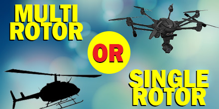 Although multi-rotor drones get most of the attention in the UAV world today, they’re not the only option for a flight project. But why would someone choose a multi-rotor over a single-rotor…or vice versa? Read on to learn the differences between the two, as well as their strengths and weaknesses.
A key difference between the two, not surprisingly, is the number of rotors each offers. A multi-rotor aerial vehicle has several rotors that keep it airborne. In contrast, a single-rotor vehicle has one rotor plus a tail rotor to control its heading.
A multi-rotor is a good choice for operators who need to get a camera in the air for a short period of time. Multi-rotor drones are best for aerial photography and aerial cinematography.
One of the advantages a multi-rotor is its high-degree of control over position and framing for aerial shots. However, a downside is speed and endurance limitations. Multi-rotor’s high-level of stabilization comes with a constant need for fast and high-precision throttle changes. As such,
Rules of aerodynamics dictate that the larger a rotor blade, the slower it spins, resulting in more efficiency. As such, a quad-copter is more efficient than an octo-copter but less efficient than a single-rotor.
Flight time isn’t due to battery, but rather weight. There are options to help increase flight duration and payload capacity.
A brushless motor for a heavy-lift electric multi-rotor is the best option for longer flight time and zero-vibration operations.
If an operators wants the drone to stay airborne longer with a more substantial camera attached, a brushless motor for heavy-lift electric multi-rotor is your best option for longer flight time and zero-vibration operation.
A single-rotor helicopter or other airborne tech project offers greater efficiency than a multi-rotor. Currently, single-rotor vehicles fill a small niche in the drone world.
Single-rotors offer certain advantages. Remember the rules of aerodynamics? A single-rotor helicopter allows for longer blades to enable slower spinning and therefore expend less energy. Some applications require extended hovering, heavy payloads and/or long endurance. In these instances, a single-rotor may be the right option.
However, single-rotor helis also have disadvantages.
One knock is that they have significantly more vibration than a multi-rotor UAV. The larger blades also pose more danger. If a single-rotor UAV loses its overhead blade, the aircraft doesn’t feature the fail safe of additional propellers.
Whether flying a multi-rotor or a single-rotor, quality parts and components are vital for safety and performance.
From pocket quad-copters for public safety to scanning depths of the ocean floor, KDE Direct constructs durable and efficient brushless motors and propeller blades for various applications. KDE Direct designs large motors, such as the KDE8218XF-120, for heavy lift down to miniature motors.
KDE Direct UAS Multi-Rotor Brushless Motor Series is designed for UAS applications. These high-quality engineered motors provide zero-vibration operation for hours of maintenance-free usage and market-leading performance. The motors are tuned and optimized for the KDE Direct UAS Multi-Rotor Electronic Speed Controller Series.
KDE Direct is a worldwide leader in single-rotor brushless motors. The Generation 3 series uses top-tier materials and manufacturing processes to take the limits of efficiency, flight performance, and maintenance-free durability to new heights. The “G3” series provides state-of-the-art technology and performance-enhancements for the single-rotor marketplace and UAS applications.
 A former NASA engineer is harnessing the potential of drone technology for a very ambitious project.
The project? Ecosystem restoration.
More precisely, scaling reforestation projects to a size previously unimaginable.
The goal? Plant 1 billion trees every year…via drone.
Lauren Fletcher spent 20 years at NASA as an engineer before founding BioCarbon Engineering. The startup’s entire focus is reforestation. More precisely, reforestation via the use of drones.
BioCarbon Engineering plans to combat deforestation and restore global forests with a unique solution. Their platform takes the best data available and enables local specialists to restore their landscapes both quickly and affordably.
Advancements in technology facilitated the large-scale harvesting of forests. Now, in a process known as clear cutting, acres of forests are harvested in a single day. Each year, it is estimated that clear-cutting is responsible for the disappearance of 26 billion trees around the world.
Reforesting such vast areas is a challenge.
The end result? Trees are cut down much quicker than they are replaced.
Industrial-scale deforestation around the world is threatening to upset the ecosystem’s balance. To combat the danger, reforestation projects continue to gain prominence.
Through various initiatives, many countries are actively working to replace trees.
Traditionally, reforestation is done by hand. On average, a single individual can plant 3000 seeds or saplings in a day. This method is labor intensive and time consuming which makes closing the gap on deforestation frustratingly slow.
BioCarbon Engineering believes technology holds the answer. Drone technology can speed up and improve the process of replanting trees. They hope to improve the replanting rate to a projected 36,000 plants per day…or 1 billion trees in a year.
Because terrains can vary, using drones to plant trees and regenerate forests is not meant to replace the human element, but complement it.
BioCarbon’s plan? Modify consumer drones so they can plant seeds and tree saplings. But that’s just the start. What follows is a simple, yet clever way of using the drones to improve the speed and efficiency of replanting efforts.
First, drones fly over a potential site, take photographs and conduct an aerial surveys. The team then creates a 3D aerial map and a “seeding” plan suitable for the terrain.
The team developed specialized pods which contain germinated seeds packed in a nutrient-rich substance. These bio-degradable pods sustain and protect the young plant until it can take root.
The pods load into a pressurized canister aboard the drone and fire into the ground. Drones fly a path that is roughly 3-6 feet above the ground. The number of drones in operation depends on the size of the site.
BioCarbon estimates that just two drone pilots operating multiple UAVs can plant up to 36,000 saplings a day.
If successful, the company’s approach would significantly improve global reforestation efforts.
Today, some of the highest rates of deforestation occur in Latin America, Brazil, Malaysia, and the Philippines. Additionally, parts of Africa face the same issue. This may explain why Fletcher and BioCarbon are targeting projects in South Africa and the Amazon jungle first.
In addition to improving reforestation efforts, drones can also access areas that are inaccessible to humans. Plus, BioCarbon believes this technology can help improve the overall health of local ecosystems. For example, pods can help spread various fungi and micro-organisms that improve soil quality as well as diversify the species of trees replanted in the forest.
The efforts of BioCarbon is another example of drone use for humanitarian purposes. The company’s goals align with the UN’s plan to restore up to 300 billion trees by the year 2030. And, tree planting drones may just bring that goal within reach.
 MicroPilot recently announced the successful interface of SightLine Applications’ landing assist functionality with MicroPilot’s autopilots.
This new functionality gives integrators the option of a robust landing assist feature. As such, it helps reduce operator workload and training requirements. This feature rolls out in version 3.7.1016 of MicroPilot’s HORIZONmp software.
SightLine Applications’ Landing Aid is a video based landing assist. It enables safe operations, even in GPS degraded (urban canyon, indoors, etc.) or GPS denied environments.
Landing Aid uses a down-facing camera mounted on the UAV to track on a specified “landing pattern”. It provides accurate relative-position data to the autopilot. This enables the UAV to land with more precision than conventional GPS.
The 8gm video processor enables low SWAP landing assist implementations.
As the use of UAVs expands into a variety of civil and commercial applications, autonomous precision landings become more vital. SightLine’s Landing Aid taps into this need. Its functionality, along with reduced operator workload, and its landing area safety checks, sets Landing Aid apart.
Previously, MicroPilot demonstrated compatibility with SightLine video processors, which are in a wide range of ISR gimbaled camera systems. Integrating SightLine Applications’ landing assist functionality with the autopilot was a logical next step. This provides a convenient package encompassing both a professional grade UAV autopilot and video landing assist for the ever-advancing UAV market.
Started in 1994, with 1000 clients in over 85 countries, MicroPilot is the world leader in professional autopilots for UAVs and MAVs. An ISO 9001 autopilot manufacturer, MicroPilot brings to market an ISO 9001 sub 30 gram autopilot, triple redundant autopilot, and full-function general purpose autopilot. It offers a family of lightweight UAV autopilots that can fly fixed-wing, transitional, helicopter, and Multirotor UAVs. MicroPilot also provides complementary products such as the XTENDERmp SDK, and trueHWIL2.
Shop MicroPilot’s line of autopilots at Unmanned Systems Source.
 VectorNav Technologies announced it received accreditation for the AS9100 Rev. D international aerospace standard for its Dallas, Texas headquarters.
AS9100 is a set of quality requirements established by the aerospace industry to satisfy DOD, NASA and FAA quality requirements. These quality requirements are based on ISO 9001 standards.
“Earning the AS9100 designation for our Dallas facility demonstrates we are a highly capable supplier to the aerospace industry. Operating to the highest standards of quality is a core principle for us,” said Scott MacDonald, Process and Quality Engineer at VectorNav. “This certification reflects our continued commitment to ensure our processes and systems deliver products and services that exceed our customers’ quality, cost, and speed expectations.”
Founded in 2008, VectorNav is a market innovator of miniature, high-performance MEMS- and GPS/GNSS-based inertial navigation systems. The releases of VectorNav’s surface mount VN-100 IMU/AHRS, VN-200 GPS/INS and VN-300 dual antenna GNSS/INS were each market firsts. Recently, the company released a line of tactical-grade inertial navigation systems that delivers an excellent price/performance ratio.
The AS9100 accreditation marks VectorNav’s achievement in demonstrating the highest level of manufacturing, quality and customer service standards. The certification represents VectorNav’s ability and commitment to deliver the highest quality miniature inertial navigation systems — from rapid procurement during testing and development to high-volume capacity for integration and production.
Shop VectorNav’s entire line of sensors, industrial and tactical, at Unmanned Systems Source.
