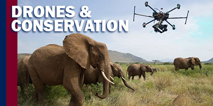
 An unlikely contender in the battle for wildlife conservation has entered the ring: drones.
Thanks to an ability to cover large areas at low costs, drones are playing a part in the reduction of wildlife threats.
Globally, drones aid in everything from migration tracking and nest surveys to habitat management and anti-poaching activities.
Drones are changing wildlife conservation around the world.
Since the 1970s, orangutan numbers have decreased sharply. Currently, the International Union for the Conservation of Nature and Natural Resources (IUCN) lists orangutan’s as critically endangered.
Today, orangutans face growing threats from poaching and palm oil production across South Asia. Monitoring these animals is now more important than ever.
Conserving the orangutan population effectively requires producing data that is both accurate and timely. Data includes the density, distribution, and land cover change of these animals.
Collecting such data even once was time-consuming and challenging for rangers to acquire via ground surveys. Now, this task is increasingly more efficient with the aid of UAVs.
Today, the Sumatran Orangutan Conservation Program (SOCP) in Indonesia flies drones above the tree canopy. Drones monitor and track endangered populations by observing nests.
Drones, equipped with video cameras, capture high-resolution images that are often too costly to obtain otherwise. Plus, drones can fly pre-programmed missions autonomously for up to 50 minutes and over a distance of 25 km. This helps researchers survey and map forests as well as their biodiversity.
South Africa is home to more rhinoceros than any other country, housing 83% of Africa’s rhinos.
Unfortunately, the country also experiences the highest levels of poaching, which is the primary threat to the conservation of the species.
In recent years, poaching deaths increased significantly. The continent’s elephant population declined by 30% from 2007 to 2014. In 2015, poacher’s killed at least 1,338 for their horns, threatening the complete extinction of elephants and rhinoceroses.
Past efforts to stop poaching throughout the country have seen little success—until now.
Backed by funding from the World Wildlife Fund, including $5 million from Google, teams are evaluating their ability to combat poachers.
The Air Shepherd Initiative (ASI) group uses analytics to identify poaching areas. Once areas are identified via the algorithm, drones equipped with night vision are sent to track poachers. Once poachers are spotted, rangers are sent to intercept the invaders.
Flying drones up to 15 miles away at night gives ASI critical advantages.
The majority of poachers know that patrols are less effective after dark. Most poaching occurs at night, leaving the parks highly vulnerable once the sun sets. Night vision equipped drones are changing that disadvantage.
Since the program’s launch, ASI completed over 4,000 missions across 3 countries.
Traditionally, biologists and zoologists use helicopters, small planes and satellite photography to learn the migration habits of wild animals. However, these methods take a significant amount of time and resources.
“Drones offer a very safe, green, and inexpensive alternative to manned aircraft,” said David Bird, professor of wildlife biology at McGill University.
Significantly smaller and more affordable, drones still capture detailed photographs needed for these efforts. Also, drones can be fitted with thermal cameras and sensors for more accurate monitoring.
Not only do drones utilize less resources, they’re also safer. According to Bird, small plane and helicopter crashes are leading causes of death for wildlife biologists counting animals or surveying nests.
In Antarctica, marine biologists from Duke University use drones along coastlines and nearby seas to monitor the habits of humpback whales.
The team hopes to learn how many whales work together to feed and if roles vary. And the advantage of observing such behavior from above via drone, versus from a boat or from ashore, are numerous.
 At the request of U.S. national security and law enforcement agencies, the Federal Aviation Administration (FAA) is using its existing authority under Title 14 of the Code of Federal Regulations § 99.7 – “Special Security Instructions” – to address concerns about unauthorized drone operations over seven Department of Energy (DOE) facilities.
The FAA and DOE have agreed to restrict drone flights up to 400 feet within the lateral boundaries of these sites:
The airspace restrictions are shown in an FAA Notice to Airmen (NOTAM) and the details about where drone flights are restricted are here.
These UAS National Security restrictions are pending until they become effective on December 29, 2017. There are only a few exceptions that permit drone flights within these restrictions. Drone operators must seek exceptions from the individual facility and/or the FAA.
To ensure the public is aware of these restricted locations, the FAA created an interactive map online. The link to these restrictions is also included in the FAA’s B4UFLYmobile app. The app will update within 60 days to reflect these airspace restrictions. Additional information, including frequently asked questions, is available on the FAA’s UAS website.
Operators who violate the airspace restrictions may be subject to enforcement action, including potential civil penalties and criminal charges.
This is the first time the agency has placed specific airspace restrictions for unmanned aircraft, or “drones,” over DOE sites. The FAA has placed similar airspace restrictions over military bases that currently remain in place, as well as more recently issued UAS flight restrictions over 10 Department of Interior facilities, including several large dams and iconic landmarks.
The FAA continues to consider restriction requests from other federal security agencies for restrictions using the FAA’s § 99.7 authority to support national security and defense.
FDC 7/6429 FDC SECURITY SPECIAL SECURITY INSTRUCTIONS FOR UNMANNED AIRCRAFT SYSTEM (UAS) OPERATIONS FOR MULTIPLE LOCATIONS NATIONWIDE. THIS NOTAM SUPPLEMENTS THE UAS-SPECIFIC SPECIAL SECURITY INSTRUCTIONS DEFINED BY FDC 7/7282 AND IMPLEMENTED PURSUANT 14 C.F.R. 99.7 AND HAVE BEEN APPLIED TO AIRSPACE OVER ADDITIONAL NATIONAL SECURITY SENSITIVE FACILITIES. THE UPDATED LIST OF AFFECTED AIRSPACE AND ASSOCIATED PROTECTED LOCATIONS, AND OTHER IMPORTANT INFORMATION ARE PROVIDED AT THE FOLLOWING FAA WEBSITE: HTTP://UAS.FAA.OPENDATA.ARCGIS.COM. SEE FDC 7/7282 FOR COMPLETE INFORMATION ON THESE SPECIAL SECURITY INSTRUCTIONS. 1712290001-1902012359
 Recently, Raytheon announced the development of a “Block 2” update of the Coyote, a tube-launched unmanned aircraft system (UAS) it acquired more than two years ago.
The aim is to produce a low-cost, multi-mission-capable air vehicle that users ultimately dispose of once it completes a mission.
“We do recover and reuse them in our development work. However, for operational use and purposes, it is meant to be disposable or ‘attritable’. It’s meant to be a one-time platform just like a Tomahawk missile,” said John Hobday, Raytheon’s Coyote business development lead.
“The difference is that we are approaching the Coyote platform not only as a disposable, but as a low-cost system. That’s part of the disruptive nature of what we’re trying to do with this platform—to create this low-cost appliance, if you will.”
Originally, a company named Advanced Ceramic Research, of Tucson, Arizona, developed the Coyote, Manta and Silver Fox UAS under small business contracts from the U.S. Office of Naval Research (ONR). Defense contractor BAE Systems acquired the company in 2009, then sold it back to one of the former owners under the name Sensintel. Raytheon acquired Sensintel in 2015 and folded the company into its Tucson-based Missile Systems business.
The 13-pound, propeller-driven air vehicle, features foldout tandem wings and tail fins. It deploys from a standard A-size sonobuoy tube with a parachute, or from a pneumatic ground box launcher.
Potential missions include using the Coyote fitted with sensors for intelligence, surveillance and reconnaissance (ISR), as a communications relay, an electronic warfare asset or a loitering munition. Another scenario envisions multiple Coyotes working cooperatively as a drone swarm.
The Coyote is larger and carries a four-pound payload. This is more than available from the similar AeroVironment Switchblade, a six-pound flying munition and ISR platform; and the four-pound Lockheed Martin Vector Hawk, a canister-launched drone that has deployed from an autonomous underwater vehicle.
Raytheon (Chalet 294, Static B8) is redesigning the Coyote to incorporate a turbine engine for high-speed applications, in addition to the current battery-powered pusher propeller approach, Hobday said.
The manufacturer’s focus is to maintain a common airframe which can launch from the ground, a ship or an aircraft.
The National Oceanic and Atmospheric Administration (NOAA) used the Coyote as a sensing platform to conduct hurricane research. The agency first deployed the small UAS in a hurricane in September 2014 when it launched the Coyote from a Lockheed WP-3D Orion turboprop into the eye of Hurricane Edouard.
The Lockheed Martin C-130 and Cessna Caravan have also served as launch platforms for the Coyote, Hobday said. Under an ONR future naval capability program, Raytheon is working to introduce it on the Boeing P-8A Poseidon antisubmarine warfare aircraft, a derivative of the 737-800 airliner.
Work also continues with NOAA and the four U.S. military services, Hobday said. He declined to comment on a report in specialist defense journal Janes earlier this year, based on an interview with Raytheon executives, that the U.S. Army has asked the company to develop the Coyote as a counter-UAS asset to intercept rogue drones.
“All of the various iterations of the Coyote airframe are driven by customer requirements,” Hobday said. “This is a system that we can very rapidly modify for emerging missions to meet new requirements that our various Department of Defense customers have for different types of missions, different concepts of operation.” He added: “Always the intent is a very low-cost, commoditized ‘truck’ that is disposable at the end of whatever its defined mission is.”
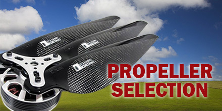 To choose the optimal drone propeller blade, the user should consider a number of factors.
Drone propeller blades have a significant influence on power and affect how smoothly a drone flies.
As such, flight efficiency is one of the most important considerations. It begs the question, how will new drone propeller blades improve the flight efficiency of your multi-rotor UAV?
When selecting new drone propeller blades, the following factors are important considerations:
The number of blades required per propeller will vary depending on the platform, usage and payload requirements.
Drones for racing and acrobatics most frequently use smaller blades, under eight inches. Smaller blades are generally paired with smaller motors with high kV ratings.
Larger blades, over eight inches, are paired with motors that have low kV ratings. These blades are used to carry heavier payloads, such as video equipment or spraying containers for agriculture.
Pitch is defined as the traveling distance per a single revolution of the propeller. The correct pitch will often depend on the specific application for a UAV platform.
Lower pitch often results in more torque and less turbulence for lifting. As a result, the motors do not have to work as hard to carry heavy payloads. And, since the motors draw less current from the battery, it results in increased flight time.
Propellers with higher pitches move more air but generally create more turbulence and less torque.
Typically, a larger diameter propeller blade allows greater contact with the air. This relates directly to flight efficiency, as a small increase or decrease in diameter can change how efficiently a drone performs.
In comparison to smaller propellers, larger propellers tend to provide more stability when hovering.
However, smaller propeller blades require less effort to speed up or slow down than larger ones. This makes smaller blades more responsive than larger propellers.
Smaller propellers with a high pitch are better suited for fast and quick maneuvers. Larger propellers with low pitches are more appropriate for carrying heavier payloads and aerial video cameras.
In summary, selecting the most appropriate propeller blades depends on the planned use as well as additional factors. Understanding how propeller blades effect drone performance helps remove some of the guess work.
 Embry-Riddle Aeronautical University’s Worldwide Campus will once again offer a free, two-week Massive Open Online Course (MOOC) on drone operation called Small Unmanned Aircraft Systems: Key Concepts for New Users.
Scheduled to run from Jan. 22 to Feb. 4, the open-to-all course covers everything new users need to know in order to safely operate personal drones.
Participants will learn about equipment, airspace, legal requirements and flight planning tools, as well as how to step up to the next level and become commercial drone operators.
“We have had consistently great feedback about this course,” said Dr. Kristy Kiernan, who is the lead educator for the class. “We are especially excited about the updates and changes we have made to reflect the most up-to-the-minute information in this rapidly changing part of aviation.”
The instructors for the class include full-time Embry-Riddle faculty members and experts from the unmanned aircraft systems industry. Embry-Riddle has offered this MOOC annually since 2015.
“One of the strengths of this class, and of Embry-Riddle in general, is the partnership we have with industry,” Dr. Kiernan said. “Our students get the best academic experience, plus the benefit of contact with real-world challenges.”
Registration for the sUAS MOOC begins Dec. 11 at worldwide.erau.edu/massive-open-online-courses.
The next upcoming MOOC offered by Embry-Riddle Worldwide will be:
Embry-Riddle Aeronautical University offers a bachelor’s degree in specializing in Unmanned Aircraft Systems at its Daytona Beach and Prescott, AZ campuses, as well as a bachelor’s degree in Unmanned Systems Applications and a master’s degree in Unmanned Systems through its online Worldwide campus. Embry-Riddle also offers professional development courses.
 The race to develop vehicles powered by clean energy is well on its way. Currently, electric and hybrid cars are readily available on the market. As for drones, most already rely on “clean energy” in the form of lipo batteries, to operate.
Solar energy is one sector, however, where exploration is still in its infancy.
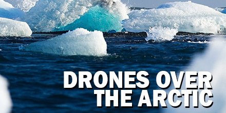
Recently, researchers from the Autonomous Systems Laboratory and Glaciologists from ETH Zurich collaborated on a special project: Sun2Ice. The goal? Develop a solar-powered drone and test its ability to monitor glaciers over the vast expanse of the Arctic.
Given the size and immensity of glacial landscapes, the challenge for scientists was designing a vehicle that offered extended flight times. To accomplish this, the team looked to harness the power of the sun.
The end result was AtlantikSolar, a UAV equipped with solar panels that allowed it to stay aloft for days.
In terms of finding an optimal place to test this developmental craft, the Polar Regions — with its continuous daylight — proved ideal. The research team hoped to use the midnight sun to create perpetual unmanned flight conditions. And, thus, provide the UAV the endurance required to survey the vast landscape.
Guillaume Jouvert, a Hydraulics, Hydrology and Glaciology senior researcher, and Thomas Stastney, a PHD student in Autonomous systems at ETH Zurich, lead the project. They put together two teams from their respective fields to attempt that goal.
As can be expected with any event that requires the weather to play nice, things didn’t quite go according to plan. But the results of the test still provided some useful insight. Qaanaa, a small town in Northwestern Greenland, served as the epicenter. This test location is surrounded by several calving glaciers, accessible by plane, yet still well connected. Tests were to occur in June 2017. However, when the team arrived a takeoff and landing spot identified months earlier, was no longer viable.
The UAV’s payload included a ground-facing camera and additional sensitive equipment. Rough landings were out of the question. So began a week of feverish work to create a suitable landing site for the UAV. Additional delays included heavy fog that lasted for several days. Despite the setbacks, clear skies opened up at the end of June. The tests could finally start.
The first test flight for AtlantikSolar’s was a 24-hour circular trip. The solar-powered craft took off on June 20.
Unfortunately, 12-hours into the flight, the test was cut short as thick fog returned to the region. Still, the team collected vital data. Remarkably, despite poor sunlight and stronger than expected winds, battery levels were still high, at 60 percent.
The data suggested that AtlantikSolar was on pace to achieve 20-hours of uninterrupted flight, despite the poor weather conditions. The data also suggested that 24-hour continuous flight time was achievable given the right conditions. Additionally, the results convinced researchers that the drone was ready to begin surveying glaciers. Unfortunately, the weather wasn’t done yet.
It wasn’t until July 3 that the weather cleared for the second launch. AtlantikSolar approached its first glacier less than two hours after take-off. The UAV captured images of the calving front of Bowdoin Glacier despite winds of up to 15 m/s buffeting the unmanned aircraft. AtlantikSolar successfully returned to Qaanaaq after 5-hours of flight covering 230km.
The drones’ battery still retained nearly a full charge, showing the true potential of solar-powered UAVs. In addition, the team discovered the beginnings of a break forming at the front of the large glacier. AtlantikSolar’s mapping information allowed glaciologists to visit Bowdoin in time and monitor the cracks progression until it finally broke away.
Beyond surveying the arctic, solar-powered drones have tremendous application potential. Geographic locations which enjoy long periods of uninterrupted sunshine are particularly applicable. Solar-powered UAVs, like AtlantikSolar, are low-cost vehicles with the added benefit of using renewable energy.
The results achieved by Guillaume and Thomas along with their respective teams show that harnessing the power of the sun to power vehicles is feasible in the right conditions. Of course, there is a need for additional research and development before such vehicles become commonplace. But, with the promising results achieved by AtlantikSolar, it seems like solar-powered drones are well on their way.
