The film and photography industry has quickly become one of the biggest adopters of drone technology. When DJI released a drone equipped with an HD camera and steadying technology, it was a game changer.
Suddenly, an entire niche gained affordable access to perspectives previously reserved for helicopter and fixed-wing pilots.
Most professional film and photography enthusiasts are primarily concerned with the quality of the camera. However, factors such as flight stability and ease of use are also important considerations. This short list includes 6 drones for professional film and photography that integrate these features best.
![]()
The Thor X4 Cinema Class UAS is a heavy lift octocopter. It's designed to carry professional filming cameras such as the Sony Fs700, or Canon C300.
The Thor X4 is ATI's most advanced octocopter and is optimized for professional film applications. A number of upgrades have improved the drones' overall flight and performance.
It is equipped with a dual battery box that can hold two, 20,000 mAH cell batteries, which provides a massive power source up to 40,000 mAH. In addition, the battery box gives the drone a stronger anchor point. A top plate provides extra protection for electronics and helps strengthen the frame.
Main Features:
- Designed to carry heavy cameras and other payloads
- Optimized for professional filming applications
- 18″ carbon fiber props that provide reduced flex and vibration
- Better stability even in strong winds
- Dual 20,000 mAH batteries for a combined 40,000 mAH power source
Rating: 10/10
The Chroma Camera Drone offers everything needed for professional film and photography -- all in one package.
This quadcopter boasts a 4K camera, a long lasting power source and a touch screen controller. It is also equipped with advanced safety technology and modes for assisting beginner pilots.
The Chroma Camera Drone is fairly easy to fly with smooth and predictable response. Plus, its aerial photography mode makes it easy for pilots to capture great shots.
It also uses GPS and GLONASS for exceptional positional accuracy and reliability. It also captures steady and distortion-free images in amazing 4K high definition. Safety features include:
Follow Me and
Tracking modes, as well as a
Return Home function. These features enable safer landings and enhance the equipment’s security. In addition, the Chroma Camera Drone allows for adjustable flight boundaries for responsible flying.
Main Features:
- Flight ready drone equipped with a stabilized 4K CGO3 camera
- ST-10+ Controller with a touch-screen display
- Smart Mode feature for first-time pilots
- Aerial Photography mode for great panning and tracking shots
- Adjustable flight boundaries
- Return home mode for safe landings at the start-off point
Rating: 9/10
The Phantom 3 Professional is widely regarded as one of the best film and photography drones available today.
The Phantom 3 has worry-free navigation -- even while it processes and completes complex calculations in real time -- to assist pilots during flight. It isequipped with GPS-assisted hover to help operators keeps track of the equipment and easily fly the UAV back home.
The Phantom 3 also boasts an unmatched propulsion system for its class and a smart battery for increased power. Sensors calculate battery power in real time so that pilots always know how much flight time is left.
In addition to the above features, the DJI Phantom 3 Professional also compiles automatic Flight Logs, including flight route, time and distance information, as well as cached versions of any shots or video taken during the flight.
Main Features:
- Ultra HD recording with a 4K camera
- Lightning fast brushless motors for fast, agile, and responsive flight
- Advanced autopilot for automatic take off, flight, and return at the push of a button
- Automatic flight logs that save details of each flight for future reference
- Three axis gimbal for improved stability, crisp images, and smooth footage
Rating: 9/10
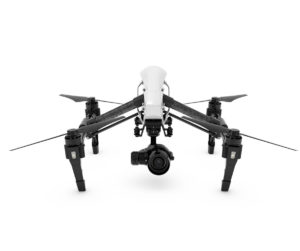
The DJI Inspire 1 Pro/Raw is a professional filming platform that combines the best of DJI's industry leading UAV technology and world class imaging capabilities.
The Inspire 1 Pro/Raw drones are the smallest and easiest to fly in their class. They come equipped with the Zenmuse X5 and X5R professional cinema-quality cameras.
The DJI Inspire 1 Pro/Raw has all the features flyers have come to expect: one button take-off, stable flight, return home, 360° camera views, to name a few.
Main Features:
- The world's smallest and easiest to fly professional aerial filming platform
- Cinema quality Zenmuse X5 and X5R cameras designed for aerial imaging
- Remote camera focus
- Comprehensive control of drone and camera at all times
- New design propellers and motors for fast and agile flying
- Intelligent flight modes include home lock, course lock, and points of interest
Rating: 9/10
The Q-Cop 450 Quadcopter from Hitec is the company's first multirotor drone and is designed for high performance flying and image capture.
Its aerodynamic design ensures greater flight stability. Its built-in high definition camera captures high resolution aerial photos and real-time videos.
Q-Cop 450 features include ultra-efficient propellers and brushless motors, and flight aids such as an autopilot return function.
Main Features:
- Streamlined, ergonomic design for incredible flight stability and performance
- Built-in high performance 90° vertical HD camera with shock isolation
- GPS enabled directional control
- Automatic return-to-home feature
- 22-33 mph cruising speed and 20-25 minutes of flight time
- 300m range for streaming video direct
Rating: 7/10
As a company, Yuneec has developed and manufactured RCs for over 15 years. The Typhoon Q500 4K brings that expertise together and, as such, is considered the company's flagship drone
.
The Typhoon Q500 has smooth and stable flying. Plus, its all-in-one controller gives the operator camera control and a first-person view of images.
The Typhoon Q500 is capable of capturing ground videos and photos thanks to a hand-grip option, which is included.
For new pilots, the Typhoon offers two autonomous modes:
Follow Me which tethers the drone to its controller and
Watch Me which keeps the pilot in the frame of view.
The Typhoon Q500 4K's sturdy body and strong arms highlight its quality construction and make the UAV a complete professional film and photography package.
Main Features:
- Responsive controls and smart modes for easy flying
- Strong, sturdy and durable construction
- Personal Ground Station with built-in touchscreen
- CGO3 4K 3-axis Gimbal Camera
- Handgrip for capturing ground footage
- Watch Me mode that continuously keeps pilot in focus
- FAA compliant No Fly Zone feature
Rating: 7/10
Film and photography professionals, as well as enthusiasts, have a growing number of drones from which to choose. As for now, the drones outlined are a great place to start. They provide a nice combination of high quality cameras, smooth and stable flying, and ease of use.

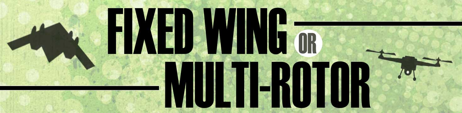
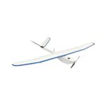
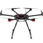 Multi-rotor Considerations
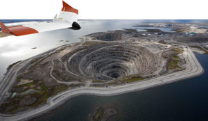 Your challenge, should you choose to accept it…
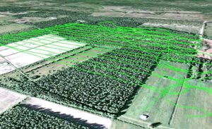
You’ve been asked to survey some points on the ground with centimeter-level accuracy. Feeling confident?
How about a few hundred points spread over 7.5 hectares (18.53 acres) and the job has to be done in one afternoon. Throw in the fact that the area you have to survey is in a quarry which has been closed off due to a recent landslide. Still feeling confident?
You should and here’s why.
Improvements in Unmanned Aerial Vehicle (UAV) technology combined with more compact high-end Global Navigation Satellite Systems (GNSS) receivers means that you no longer have to compromise on precision to measure in those hard-to-reach areas.
Your challenge, should you choose to accept it…
You’ve been asked to survey some points on the ground with centimeter-level accuracy. Feeling confident?
How about a few hundred points spread over 7.5 hectares (18.53 acres) and the job has to be done in one afternoon. Throw in the fact that the area you have to survey is in a quarry which has been closed off due to a recent landslide. Still feeling confident?
You should and here’s why.
Improvements in Unmanned Aerial Vehicle (UAV) technology combined with more compact high-end Global Navigation Satellite Systems (GNSS) receivers means that you no longer have to compromise on precision to measure in those hard-to-reach areas.
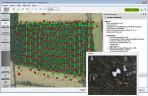
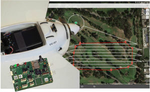 UAVs have become more reliable and easier to work with: from programming flight paths to installing additional equipment on board, UAV applications are no longer confined to a limited group of specialists.
For a survey flight, your UAV will need to have installed: a high-resolution camera and a high-end GNSS receiver module. To fly the UAV through a pre-programmed flight plan, an autopilot flight controller is often included.
UAVs have become more reliable and easier to work with: from programming flight paths to installing additional equipment on board, UAV applications are no longer confined to a limited group of specialists.
For a survey flight, your UAV will need to have installed: a high-resolution camera and a high-end GNSS receiver module. To fly the UAV through a pre-programmed flight plan, an autopilot flight controller is often included.