INSPIRE 2 Available for Pre-Order
DJI is enhancing the imaging potential of the Inspire 2 by expanding its line of interchangeable Zenmuse cameras, which are designed for aerial imaging and communicate directly with the aircraft’s gimbal and flight controllers. For situations that require a balance between weight and image quality, the new Zenmuse X4S has a 1-inch, 20-megapixel sensor with 11.6 stops of dynamic range and a 24 mm equivalent focal length. The Zenmuse X4S offers aperture control (f2.8-11) and a mechanical shutter that cancels rolling shutter distortion. The new Zenmuse X5S has a larger Micro Four Thirds sensor with 20.8 megapixels and an incredible 12.8 stops of dynamic range. The Zenmuse X5S camera now supports 8 lenses from wide angles to zooms. It shoots 20fps continuous burst DNG RAW (20.8 MP). In the future, a handheld mount will be available for the Zenmuse X4S and X5S cameras, bringing those cameras down to the ground for more flexible filmmaking.
PRICE AND AVAILABILITY
The U.S. retail price of the Inspire 2 aircraft is $2,999. The Inspire 2 Combo, which includes one Inspire 2 aircraft, one Zenmuse X5S, CinemaDNG and Apple ProRes License Key, is available for $6,198. Customers who order the Inspire 2 Combo before January 1, 2017 can enjoy a special price of $5,999.
Inspire 2 and its accessories will be immediately available for
pre-order here. Inspire 2 Combo will start shipping in early December 2016 while customers who purchase the aircraft and camera separately can expect their orders to start shipping in early January 2017.
PHANTOM 4
Phantom 4 Pro offers a powerful imaging system for professional photo and video creators as well as non-professionals who demand excellence from the camera and platform they use to pursue their creative visions. The camera now packs a 1-inch 20-megapixel sensor, and almost 12 stops of dynamic range bring out levels of detail and low-light performance unprecedented in a flying camera of this size. Its mechanical shutter eliminates rolling shutter distortion in fast-moving scenes. Phantom 4 Pro can capture slow-motion 4K video up to 60 fps at a maximum bitrate of 100 mbps. In addition, the Phantom 4 Pro offers H.265 video compression, which substantially improves video quality at the same bitrate.
PRICE AND AVAILABILITY
Phantom 4 Pro’s U.S. retail price is $1,499 with a standard controller. The Phantom 4 Pro
+, which includes a Phantom 4 Pro aircraft, and a high luminance display remote controller, will be available at $1,799. Phantom 4 Pro and Phantom 4 Pro
+ are immediately available for pre-order here. These products will begin shipping one week after launch.

 January 6, 2017 – uAvionix continues to roll-out innovative products within the Automatic Dependent Surveillance-Broadcast (ADS-B) arena.
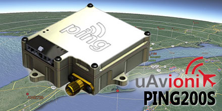
Their latest addition? The Ping200S Mode S Transponder, which just received FCC approval.
The Ping200S provides a unique combination of small size, low power and high visibility. All these factors make it an ideal choice for drones and other beyond line of sight UAV operations.
“We are excited to offer Ping200S to the market,” said Paul Beard, CEO of uAvionix. “Until now, operators requiring a transponder had to choose between unlicensed devices or heavier, power-hungry legacy solutions.”
January 6, 2017 – uAvionix continues to roll-out innovative products within the Automatic Dependent Surveillance-Broadcast (ADS-B) arena.
Their latest addition? The Ping200S Mode S Transponder, which just received FCC approval.
The Ping200S provides a unique combination of small size, low power and high visibility. All these factors make it an ideal choice for drones and other beyond line of sight UAV operations.
“We are excited to offer Ping200S to the market,” said Paul Beard, CEO of uAvionix. “Until now, operators requiring a transponder had to choose between unlicensed devices or heavier, power-hungry legacy solutions.”
 What exactly is ADS-B and do I need it?
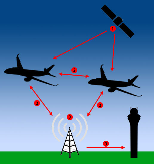 1. GPS satellites provide location information to ADS-B equipped aircraft.
2. ADS-B equipped aircraft transmit altitude, speed and velocity information to other ADS-B equipped aircraft and ADS-B ground stations.
3. ADS-B ground receive stations provide aircraft location back to other aircraft, as well as air traffic control centers.
"ADS-B In" systems can be installed on any aircraft to display location information of other aircraft with ADS-B Out transmitters.
Aircraft also transmit their location directly to other “ADS-B In” equipped aircraft within their transmit area. Thus, forming a long-range mesh network that shares real-time position information.
For pilots flying with Visual Flight Rules cockpit-based ADS-B receiver displays provide earlier warning of aircraft in their flight area. This helps improve safety during inclement weather conditions.
1. GPS satellites provide location information to ADS-B equipped aircraft.
2. ADS-B equipped aircraft transmit altitude, speed and velocity information to other ADS-B equipped aircraft and ADS-B ground stations.
3. ADS-B ground receive stations provide aircraft location back to other aircraft, as well as air traffic control centers.
"ADS-B In" systems can be installed on any aircraft to display location information of other aircraft with ADS-B Out transmitters.
Aircraft also transmit their location directly to other “ADS-B In” equipped aircraft within their transmit area. Thus, forming a long-range mesh network that shares real-time position information.
For pilots flying with Visual Flight Rules cockpit-based ADS-B receiver displays provide earlier warning of aircraft in their flight area. This helps improve safety during inclement weather conditions.

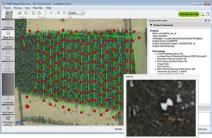
 Your challenge, should you choose to accept it…
You’ve been asked to survey some points on the ground with centimeter-level accuracy. Feeling confident?
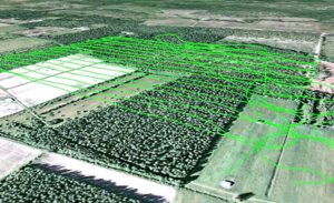
How about a few hundred points spread over 7.5 hectares (18.53 acres) and the job has to be done in one afternoon. Throw in the fact that the area you have to survey is in a quarry which has been closed off due to a recent landslide. Still feeling confident?
You should and here’s why.
Improvements in Unmanned Aerial Vehicle (UAV) technology combined with more compact high-end Global Navigation Satellite Systems (GNSS) receivers means that you no longer have to compromise on precision to measure in those hard-to-reach areas.
Your challenge, should you choose to accept it…
You’ve been asked to survey some points on the ground with centimeter-level accuracy. Feeling confident?
How about a few hundred points spread over 7.5 hectares (18.53 acres) and the job has to be done in one afternoon. Throw in the fact that the area you have to survey is in a quarry which has been closed off due to a recent landslide. Still feeling confident?
You should and here’s why.
Improvements in Unmanned Aerial Vehicle (UAV) technology combined with more compact high-end Global Navigation Satellite Systems (GNSS) receivers means that you no longer have to compromise on precision to measure in those hard-to-reach areas.
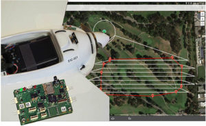 UAVs have become more reliable and easier to work with: from programming flight paths to installing additional equipment on board, UAV applications are no longer confined to a limited group of specialists.
For a survey flight, your UAV will need to have installed: a high-resolution camera and a high-end GNSS receiver module. To fly the UAV through a pre-programmed flight plan, an autopilot flight controller is often included.
UAVs have become more reliable and easier to work with: from programming flight paths to installing additional equipment on board, UAV applications are no longer confined to a limited group of specialists.
For a survey flight, your UAV will need to have installed: a high-resolution camera and a high-end GNSS receiver module. To fly the UAV through a pre-programmed flight plan, an autopilot flight controller is often included.
 PLAYAS, NEW MEXICO – June 02, 2016 – Latitude Engineering and
 Tucson, AZ – June 15, 2016 – Unmanned Systems Source is pleased to announce a new distribution partnership with AheadX, manufacturer of the Pluto N1 sensor.
Pluto N1 is an ultra-compact, low-cost Attitude and Heading Reference System (AHRS). It offers a 2D navigation solution for UGS and a 3D navigation solution for UAV and UUV applications. Plus, it can combine GPS/GLONASS to become GNSS/INS.
Tucson, AZ – June 15, 2016 – Unmanned Systems Source is pleased to announce a new distribution partnership with AheadX, manufacturer of the Pluto N1 sensor.
Pluto N1 is an ultra-compact, low-cost Attitude and Heading Reference System (AHRS). It offers a 2D navigation solution for UGS and a 3D navigation solution for UAV and UUV applications. Plus, it can combine GPS/GLONASS to become GNSS/INS.