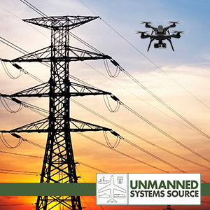
 UAV's and the Unlimited Potential for Utility Inspection
May 10, 2016 - In the past few years we have witnessed a boom in the proliferation on the Civilian market for Unmanned Aerial Vehicles (UAV's) or drones for commercial purposes.
Power, process and utility companies certainly have need of such useful tools. General points of conversation about deploying these assets usually revolve around concerns about FAA Regulations and practical questions about Return on Investment (ROI). Of additional interest to the Utility companies is the technical limitations of such remotely operated vehicles including ceiling limits, battery life, lift capabilities, and reliability.
But for the most part, utility organizations are not concerned with these particular issues. A much more pressing concern for such organizations has been how to work through the logistics of interpretation, collaboration and scalability.
Interpretation
Compliance with FAA regulations and safety requirements are not the issue as utility companies are already accustomed to operating within the legal constraints imposed by other State and Federal Authorities. The crux of the problem comes from the interpretation of such rulings. For example, if an exclusion barrier needs to be installed 500 feet from the area of the UAV's flight path to ensure any person not involved with the operation is kept out of danger, then what does that barrier need to consist of?
Collaboration
Utility companies do not need to compete with one another which allows them greater scope to collaborate on common issues. However, regional and logistical differences can make efficient collaboration more difficult in practice.
Scalability
The sheer scale of the area to be covered also poses another issue with some utility companies operating over a massive area and employing numerous departments and sub-departments. In such instances the utilization of drones can be a double-edged sword when measuring costs versus potential savings across the entire infrastructure.
Looking to the Future
In spite of the many challenges that are inherent with utilizing UAV's, certain industry professionals see the potential for such innovation within their own organization's structures. Dave Truch, Technology Director of Digital Innovation at BP, believes that UAV's have changed the paradigm:
Drones are the culmination of data collection technology in a lot of different ways. Being able to take advantage of the computational and simulation capabilities that are now available has been incredible, and we can use drones to handle emergency situations in a way that wasn't possible just a few years ago.
This change enables utility companies the opportunity to look not just at how they are doing things like inspecting installations and power lines but also how they want to accomplish these tasls in the future. The democratization of UAV technology now allows utility companies to customize the function of a particular drone or fleet of drones to best suit their own particular needs. This serves both to decrease outgoing costs and to make the operation of such units considerably safer to company employees.
Understanding the Scale, Scope and Setup of Utility Operations
Many utility companies face the unique challenge of monitoring and repairing thousands of miles of infrastructure. The costs associated with installing a new tool or process throughout an entire organization can be be enormous. But this issue of scale can work to the advantage of a Utility company once the set-up phase is complete.
Jonathan Evans is the CEO of Skyward, a company he founded to help clients launch their own UAV programs, manage operations, and safely integrate their fleet of drones within the national airspace. Some of these organizations are publicly traded utility companies who are by their nature risk averse. The potential negative publicity from even a single safety breach or the heavily publicized lawsuits that might follow could significantly damage shareholder confidence and potential future investment into the business. But these organizations also recognize an opportunity when it presents itself. As Jonathan explains:
Utility companies have massive infrastructures, which means if they can use a tool to increase efficiency or reduce costs, moving the needle just a little bit can have a big economic impact.
He elaborates his point further by describing a typical Utility company problem:
When you're looking at inspections of power lines, gas lines, and especially cell phone towers, utilizing a tool like a drone can mean a serious investment, but it can have a tremendous benefit.
Lower-cost Alternative to Helicopter or Light Aircraft Surveys
One niche area where drones are making strong headway in replacing traditional technologies is that of
Aerial Surveying that previously could only be conducted by hiring helicopters or light aircraft.
When they initially appeared on the scene, the price point of operating a drone was almost comparable to that of a helicopter or light aircraft performing a similar role. Tasks such as monitoring areas of infrastructure or observing dangerous situations such as downed power lines were previously only possible with manned aircraft and the ensuing costs involved.
But with costs coming down almost exponentially in recent years, UAV technology now provides an extremely attractive alternative both in terms of price and flexibility.
Frank Scumacci is the Director of Strategic Initiatives at ComEd and he is eager to see how drones could change things at his company. He explains his approach to the new technology:
In terms of what we're doing from a utility perspective with drones, we've been working hand in hand with other industry leaders. The nice thing about our industry is that we're able to share information because we don't compete. It's not a retail market. The work that we and another handful of companies are doing in this market is creating the groundwork for operations across the country.
Safer and More Efficient Operations
Utility operations by their nature inherently involve risk. Tasks such as setting up power lines, scouting for oil in treacherous conditions, upgrading existing cell phone towers are all hazardous activities and have the potential to lead to dangerous situations. This danger is even more pronounced for the emergency response personnel sent in when something does go wrong.
UAV's offer the possibility to remove humans from potentially harmful situations. As Dave Truch explains:
In our case, the majority of our excitement is around the ability to do remote sensing without humans. A lot of our activity is based on putting humans in unsafe environments to do basic data collection or do visual observation and monitoring of our activities. So we've often had to put humans in these very remote, far away, harsh arenas where it's been a challenge to get anything other than spot inspections. With these tools, we can take people completely out of those dangerous situations.
But UAV's don't just simply remove people from a potentially unsafe working environment. They also allow real-time information to be gathered and sent back to the decision maker without putting themselves in harm's way either strapped to the side of a tower or hovering high up in a helicopter. This naturally reduces the increased stress levels that are triggered when faced with the rational fear of serious injury or death to one's self, thereby allowing the knowledge expert to take a more measured approach to the situation and to figure out the best solution in a faster time.
The key to UAV implementation in such scenarios according to Scumacci is to retain the previous monitoring and response procedures that have always been used but to manage them in a more efficient and cost-effective manner that the new technology affords.
Keeping People Involved
There has been an untenable degree of hype about the potential benefits and uses of UAV and drone technology in recent years. The promises of many manufacturers in regards to the capabilities their fleet of drones can bring to an organization are often fanciful at best with predictions of UAV's replacing a wide variety of previously manned operations.
This in itself is a worrying trend but none of the Utility professionals actively engaged in incorporating drones into their current operations are focused on replacing workers currently involved in such roles.
As Dave Truch concludes:
Drones are allowing us to move from a discrete, time-based activity set to a continuous, condition-based monitoring and surveillance. With a fleet of drones you can have continuous surveillance coverage over every spot at all times. You can see everything at once, which is great, but you still need a person responding and reacting to what's being shown.
It would seem that it is the tasks and responsibilities of the the human worker in the process that will change and evolve. Certain tasks currently being done by humans will be more efficiently accomplished by automation when possible, but this will free up that person to do something different allowing for an overall increase in efficiency for the organization.
Jonathan Evans sums up this likely scenario:
No matter what we're doing with a drone, we're doing it to support people. Ultimately, UAVs are tools that augment our processes to help us succeed. But the person still has to be there to judge what is or isn't happening. And that requires robust management platforms, just like we expect with other tools and systems that we use.
Moving beyond the practice of putting UAV technology in the hands of existing employees, successful drone integration will really be reached when those individuals are allowed and encouraged to develop and create procedures that will work for them and their organization.
UAVs are giving Utility companies new and far reaching capabilities around the setup, monitoring, and fixing of their infrastructures, but people are and will continue to be involved at every step of that process.

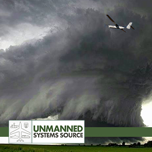 The growth of UAV applications in recent years has led to a surge of innovation in Industry and Scientific Research. Weather Forecasting and accurate storm path prediction is one such area that continues to benefit from the unique capabilities UAVs offer – including the possibility of lengthening tornado warning times up to 3-fold.
Currently, Meteorologists employ Doppler radar to help predict where a Tornado will hit to within 20 minutes. But Doppler radars has its limitations; it cannot measure air pressure directly and it is also designed to monitor higher altitudes.
Acquiring detailed air pressure measurements from ground level to 1000 feet, known as the “sweet spot”, has been problematic. UAV technology may hold the key to obtaining detailed and localized measurements, thus increasing accuracy.
The growth of UAV applications in recent years has led to a surge of innovation in Industry and Scientific Research. Weather Forecasting and accurate storm path prediction is one such area that continues to benefit from the unique capabilities UAVs offer – including the possibility of lengthening tornado warning times up to 3-fold.
Currently, Meteorologists employ Doppler radar to help predict where a Tornado will hit to within 20 minutes. But Doppler radars has its limitations; it cannot measure air pressure directly and it is also designed to monitor higher altitudes.
Acquiring detailed air pressure measurements from ground level to 1000 feet, known as the “sweet spot”, has been problematic. UAV technology may hold the key to obtaining detailed and localized measurements, thus increasing accuracy.
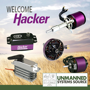 May 19, 2016 – Unmanned Systems Source is pleased to announce our latest distribution partner, Hacker Motors. Hacker Motor’s specializes in high quality, brushless motors and controllers for commercial and industrial purposes.
Hacker products include the complete line of brushless motors and controllers ranging from 25 watts to 15,000 watts for RC, UAV and industrial applications. Hacker also offers in-runners and out-runners to direct drive and geared, Hacker likely has a quality lightweight motor to fit your needs.
Unmanned Systems Source also offers Hacker’s DITEX telemetry servos which incorporate the latest in digital position encoders and a powerful 32-bit processor for a truly digital servo. DITEX servos also offer programmability, via a USB adapter and the manager software, and delivers numerous data points to compatible telemetry systems.
"I think developers and integrators will be really pleased with the power, programmability and price-point that the DITEX provides," said Drew Osbrink, Solutions Engineer for Unmanned Systems Source.
Visit
May 19, 2016 – Unmanned Systems Source is pleased to announce our latest distribution partner, Hacker Motors. Hacker Motor’s specializes in high quality, brushless motors and controllers for commercial and industrial purposes.
Hacker products include the complete line of brushless motors and controllers ranging from 25 watts to 15,000 watts for RC, UAV and industrial applications. Hacker also offers in-runners and out-runners to direct drive and geared, Hacker likely has a quality lightweight motor to fit your needs.
Unmanned Systems Source also offers Hacker’s DITEX telemetry servos which incorporate the latest in digital position encoders and a powerful 32-bit processor for a truly digital servo. DITEX servos also offer programmability, via a USB adapter and the manager software, and delivers numerous data points to compatible telemetry systems.
"I think developers and integrators will be really pleased with the power, programmability and price-point that the DITEX provides," said Drew Osbrink, Solutions Engineer for Unmanned Systems Source.
Visit 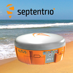 The French navy recently cleared landmines from a beach in Plouhinec, Brittany, France using Septentrio’s APS-3G, highlighting the positioning system's abilities.
Locals had discovered 30 shells in just over a year on Magouëro beach near Plouhinec, on the Western Coast of France. The country's Navy bomb disposal unit stepped in and used the APS-3G to survey the beach and identify the locations of landmines and other World War II objects numbering over 300.
Featuring cutting edge specifications and much more, the APS-3G ensures it is the perfect choice among positioning systems by offering high GNNS performance, high productivity and flexibility.
Any objects that were identified by the APS-3G were either immediately removed or had their positions marked for later removal. The mine's presence on the beach was a result of their use in World War II by the German army to protect their bunkers and a nearby submarine base.
After careful and systematic work, some of the devices found were first buried in the ground then detonated right there on the beach.
Boasting an integrated matching wide band GNSS antenna, the APS-3G is capable of delivering high quality, multi-frequency GPS/GLONASS/Galileo/BeiDou satellite technology simultaneously. The positioning system also features a digital UHF radio and GSM/GPRS.
With a compact and lightweight design, the APS-3G also offers an ease of use that means little training is required before surveyors can use the product. The device can provide reliable and continuous use through its high-capacity Li-Ion batteries that can be quickly swapped during longer periods of use.
Another great advantage of Septentrio’s APS-3G is its ability to adapt to the demands of various field conditions. The machine comes with the option of using either Cellular or UHF transmission and the ability to choose between an RTK Network or the Base-Rover to guarantee maximum uptime.
Other features of note are the 136 channel GPS GPS, GLONASS, GALILEO, & BeiDou Upgrade, integrated Bluetooth capability, and the integrated Digital UHF transceiver that ranges from 406 to 470 MHz. The APS-3G also has a removeable SD card which means surveyors can easily and quickly access the raw data for processing.
But that's not all, the APS-3G has even more innovative features. The device has patented Galileo AltBOC tracking, LOCK+tracking for solid tracking stability under conditions that may involve heavy vibrations, and RTK+ for faster initialization and extended RTK baselines.
The APS-3G is ready to use out of the box and each one comes with two Li-Ion hot swappable batteries, a 2-Bay Battery Charger, a power cable, and a serial cable.
Shop Septentrio's
The French navy recently cleared landmines from a beach in Plouhinec, Brittany, France using Septentrio’s APS-3G, highlighting the positioning system's abilities.
Locals had discovered 30 shells in just over a year on Magouëro beach near Plouhinec, on the Western Coast of France. The country's Navy bomb disposal unit stepped in and used the APS-3G to survey the beach and identify the locations of landmines and other World War II objects numbering over 300.
Featuring cutting edge specifications and much more, the APS-3G ensures it is the perfect choice among positioning systems by offering high GNNS performance, high productivity and flexibility.
Any objects that were identified by the APS-3G were either immediately removed or had their positions marked for later removal. The mine's presence on the beach was a result of their use in World War II by the German army to protect their bunkers and a nearby submarine base.
After careful and systematic work, some of the devices found were first buried in the ground then detonated right there on the beach.
Boasting an integrated matching wide band GNSS antenna, the APS-3G is capable of delivering high quality, multi-frequency GPS/GLONASS/Galileo/BeiDou satellite technology simultaneously. The positioning system also features a digital UHF radio and GSM/GPRS.
With a compact and lightweight design, the APS-3G also offers an ease of use that means little training is required before surveyors can use the product. The device can provide reliable and continuous use through its high-capacity Li-Ion batteries that can be quickly swapped during longer periods of use.
Another great advantage of Septentrio’s APS-3G is its ability to adapt to the demands of various field conditions. The machine comes with the option of using either Cellular or UHF transmission and the ability to choose between an RTK Network or the Base-Rover to guarantee maximum uptime.
Other features of note are the 136 channel GPS GPS, GLONASS, GALILEO, & BeiDou Upgrade, integrated Bluetooth capability, and the integrated Digital UHF transceiver that ranges from 406 to 470 MHz. The APS-3G also has a removeable SD card which means surveyors can easily and quickly access the raw data for processing.
But that's not all, the APS-3G has even more innovative features. The device has patented Galileo AltBOC tracking, LOCK+tracking for solid tracking stability under conditions that may involve heavy vibrations, and RTK+ for faster initialization and extended RTK baselines.
The APS-3G is ready to use out of the box and each one comes with two Li-Ion hot swappable batteries, a 2-Bay Battery Charger, a power cable, and a serial cable.
Shop Septentrio's  Tucson, AZ – April 20, 2016 – Unmanned Systems Source is pleased to announce it will host booth 861 at AUVSI’s XPONENTIAL 2016 held in New Orleans from May 2 to 5. XPONENTIAL is the largest trade show for the unmanned systems and robotics industry.
More than 8,000 industry leaders and professionals from more than 55 countries are expected to attend XPONENTIAL 2016. The exhibit hall will showcase more than 600 cutting-edge companies from around the world, representing more than 20 industries. Plus, there will be more than 300 educational sessions, including a presentation from Unmanned Systems Source distribution partner Septentrio.
“This year we will host our largest booth to date. I think anyone who stops by will quickly understand that Unmanned Systems Source is truly the one-stop destination to outfit any unmanned project,” said Jennifer Jerrick, CEO of Unmanned Systems Source. “Plus, XPONENTIAL affords us the opportunity to touch base with our partners and catchup with old friends.”
If you attend XPONENTIAL this year, make sure to visit Unmanned Systems Source at booth 861.
Visit
Tucson, AZ – April 20, 2016 – Unmanned Systems Source is pleased to announce it will host booth 861 at AUVSI’s XPONENTIAL 2016 held in New Orleans from May 2 to 5. XPONENTIAL is the largest trade show for the unmanned systems and robotics industry.
More than 8,000 industry leaders and professionals from more than 55 countries are expected to attend XPONENTIAL 2016. The exhibit hall will showcase more than 600 cutting-edge companies from around the world, representing more than 20 industries. Plus, there will be more than 300 educational sessions, including a presentation from Unmanned Systems Source distribution partner Septentrio.
“This year we will host our largest booth to date. I think anyone who stops by will quickly understand that Unmanned Systems Source is truly the one-stop destination to outfit any unmanned project,” said Jennifer Jerrick, CEO of Unmanned Systems Source. “Plus, XPONENTIAL affords us the opportunity to touch base with our partners and catchup with old friends.”
If you attend XPONENTIAL this year, make sure to visit Unmanned Systems Source at booth 861.
Visit