
UAVs May Help Extend Tornado Warning Times
 The growth of UAV applications in recent years has led to a surge of innovation in Industry and Scientific Research. Weather Forecasting and accurate storm path prediction is one such area that continues to benefit from the unique capabilities UAVs offer – including the possibility of lengthening tornado warning times up to 3-fold.
Currently, Meteorologists employ Doppler radar to help predict where a Tornado will hit to within 20 minutes. But Doppler radars has its limitations; it cannot measure air pressure directly and it is also designed to monitor higher altitudes.
Acquiring detailed air pressure measurements from ground level to 1000 feet, known as the “sweet spot”, has been problematic. UAV technology may hold the key to obtaining detailed and localized measurements, thus increasing accuracy.
Cloud-Map project takes shape
Jamey Jacob, a professor of Mechanical and Aerospace Engineering at Oklahoma State University, believes UAV technology may be the key to obtaining detailed and localized measurements, thereby increasing accuracy.
Jacob recently outlined the fundamentals of the project, Cloud-Map, at AUVSI’s XPONENTIAL 2016 in New Orleans, Louisiana.
Cloud-Map is a joint project between four Midwestern universities: Oklahoma State University, University of Nebraska-Lincoln, University of Oklahoma, and University of Kentucky. Together with the National Science Foundation they aim to triple the warning time for tornados and to improve weather predictions nationwide in general through the use of UAVs.
Droning in on the “sweet spot”
The project envisions a network of drones deployed directly from weather stations. Typically, most weather stations have a tower that reaches 30 feet into the air. Cloud-Map aims to extend this reach up to one thousand feet through the use of drones to collect data up to the altitude where Doppler radar currently covers.
This overlap in data collection should help Meteorologists get a better picture of air pressure movements nationwide and predict the path of tornadoes, hurricanes, and other extreme weather events with more accuracy.
This fleet of drones will be designed to operate up to 5,000 feet but will hone in on that all-important “sweet spot” of weather forecasting – 1000 feet above the ground – and will capture temperature, pressure and humidity data.
Currently, weather balloons are used to measure air pressure but once released they rise roughly 1,000 feet in a minute. So, while they do capture air pressure at low altitudes, they do so only for about 60 seconds before continuing their trajectory up into the stratosphere.
Designing for the Unknown
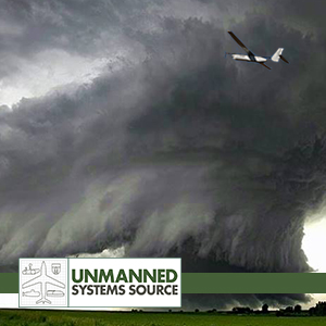
There are a lot of unknowns with the proposed deployment of UAV technology into harsh and extreme weather environments. Currently the Cloud-Map team is designing the vehicle to withstand winds up to 120 mph – essentially a Cat-3 hurricane – and still maintain critical data transmission from inside extreme weather events such as a tornado.
Jacob announced that Cloud-Map’s prototypes have been successfully stress-tested in lab conditions that prove they can withstand the extreme pressures from turbulent wind speeds without shattering. One drone reportedly sent back measurements from inside a storm that had winds gusting up to 30 mph.
But further field tests are still needed to determine if a UAV can safely operate in much more violent storms while maintaining stable flight control and the transmission of usable data. The Cloud-Map team is also considering the use of smaller multi-rotor drones which some believe may handle such extreme conditions better than larger UAVs.
Extending warning times
The advent of a UAV capable of withstanding tornado-strength winds would give scientists a new opportunity to learn more about this phenomena from a safe remote location. And with better understanding could come extended warning times and increased opportunity for individuals to seek cover from these deadly weather events.
In addition to the low-altitude drones, Cloud-Map is also developing a top-down weather measurement UAV called MARIA. The plan is to create a fixed-wing platform that would fly above a storm still in its early stages of development and drop sensor packets from above directly into the storm’s path.
More testing of the next iteration of UAV prototypes will be conducted by the Cloud-Map team in June.