 Industry is not the only sector moving towards the rapid adoption of drones for operations. In fact, a growing number of non-profit organizations are beginning to test the feasibility of drones for their work.
Recently, the Malawi Government and the United Nations International Children’s Emergency Fund (UNICEF) announced the launch of a unique testing corridor.
The corridor’s purpose is to test the effectiveness of delivering humanitarian aid via drone.
A first of its kind in Africa, the Humanitarian UAV Testing Corridor launched in June.
Today, it is fairly common to use drones for search and rescue efforts as well to capture live images of inaccessible disaster zones. But, many believe that’s just the beginning.
Given the vast area and various issues plaguing the continent, technology can play an important part in Africa’s development and growth. The continents launch of humanitarian drones may very well turn out to be the vanguard in helping to tackle some of those problems.
“This humanitarian drone testing corridor can significantly improve our efficiency and ability to deliver services to the world’s most vulnerable children,” Christopher Fabian, UNICEF Office of Global Innovation Principal Adviser said in reference to the program in Malawi.
The UAV corridor’s launch follows a successful pilot project that took place in March of 2016. The study tested the drone transport of blood samples as a way to speed up HIV diagnosis in infants. The results determined UAVs were indeed a viable addition to existing transport systems used by health providers.
Now, UNICEF and the Malawian Government are taking it a step further. The plan is to test the UAV corridor for a year with participation from over a dozen organizations. Universities, companies, and non-governmental organizations all applied to take part in the program.
Currently, Malawi has one of the highest rates of HIV infections in the world. In 2014 alone, 10,000 children died from the virus.
While large numbers of young people are tested each year, it represents only a fraction of the population. Physical constraints on the country’s health system is a primary reason testing is limited. The hope is that the drone corridor will reduce the cost and wait time of HIV tests.
The drones follow pre-programmed flight paths to carry dried blood samples between rural clinics and hospital labs.
During the pilot program, one trip took under 20 minutes to complete. The drones conducted tests at various times of day as well as in different weather conditions.
The operational advantages drones provide in these rural, underdeveloped areas are tremendous.
Malawi, with a population exceeding 18 million people, only has eight facilities that conduct HIV testing for mothers and their children. Consequently, many patients live far away from testing centers. From testing to treatment, the entire process is often delayed, sometimes by as much as two months.
Long wait times are a major issue. The sooner a child begins treatment with an antiretroviral medicine the greater the chance of survival.
The government of Malawi hopes the humanitarian corridor helps decrease HIV related deaths. But that’s just the beginning.
Ultimately, one of the aims of the trial corridor is to research the viability of adopting the use of drones across the country’s health sector.
Beyond the initial cost of purchasing sUAS, their low maintenance costs mean that drones may have an advantage over traditional transportation methods.
Malawi isn’t the only country to benefit from drones delivering humanitarian aid. In fact, a company called Zipline regularly conducts humanitarian deliveries in Rwanda.
Based outside of San Francisco, Zipline describes itself as “the world’s only drone delivery system at a national scale to send urgent medicines like blood to patients, no matter where they live.”
In the Fall of 2016, Zipline partnered with the Rwandan health ministry to deploy 15 drones to serve 21 clinics from a single base. The company uses its fleet of sUAS to deliver critical supplies such as blood and plasma to rural hospitals.
With its forested and, at times, impassable terrain, deliveries by road are painfully slow in Rwanda. Drones have the advantage of simply flying over the rugged and difficult terrain. Deliveries that took up to eight hours by road, now happen in under a half-hour.
Financed by the Rwandan Healthy Ministry, the project is a success.
The process starts when a hospital sends an order to the Zipline distirubtion center. Local crews pack the product into a small container and load it onto the drone. The drone flies to the hospital and deploys the package, which is attached to a parachute, and returns to the distribution center. Within 5 minutes, after a staff member changes batteries and loads the drone is once again airborne after a staff member changes batteries and loads a new package.
The fleet of fixed-wing UAVs can fly missions up to 50 miles away from the distribution center. The fleets conducts nearly 500 missions a day.
In January 2018, Zipline is expanding its operations into Tanzania. The scale of the Tanzanian operation is significantly larger. The plan, in partnership with the health ministry of Tanzania, is for 120 drones operating out of 4 bases. These centers will serve more than 10 million people at 1,000 clinics across the country.
The advancement of drone technology advancing into humanitarian operations is heartening. And the pioneering projects taking place across Africa are but a fraction of what’s possible. As costs go down and expertise continues to grow, drones will simply be another tool to help deliver humanitarian aid.
 Smart phones, game consoles, smart TVs…and now, drones.
New technology is exciting but the cost of owning the latest gadgets prevent many from immediately running out and buying it. Many wait months before purchasing coveted products in the hopes that competition may eventually drive the price down.
However, some savvy shoppers choose another path…refurbished products.
From smartphones games consoles, refurbished electronics are a viable option for price-conscious consumers. Refurbished products offer consumers the chance to buy updated technology at a reduced price. However, when considering refurbished gadgets, a little due diligence is required.
Technological innovation happens at a break-neck pace. Products are updated regularly and newer models are quickly made available. And, as manufacturers look to ever increase revenue, product cycles seem to get shorter and shorter.
It is easy to see how consumers are out-matched.
Refurbished products come from a variety of sources, including: ex-display items, items with slight defects from shipping, and previously owned items – to name a few. A refurbished product can have either some or all of its components replaced with newer ones. Some are done by the manufacturer. Others by private individuals or companies that specialize in the product line in question.
Just like many other types of electronics, refurbished drones are the result of the consumerist economy we live in. Here’s a quick look at the aforementioned causes behind refurbished electronics and their advantages or drawbacks, if any:
Many drone manufacturers offer refurbished drones. In many ways, it is a win-win. The manufacturer recaptures dollars they may have previously lost by refurbishing damaged goods and reselling them. And the consumer can upgrade their technology at a lower cost than buying new.
These are items that are usually in an as-new condition and have been thoroughly checked before being re-listed for sale at a lower price. So while a refurbished drone is a viable alternative for anyone looking to buy a UAV is it a foolproof path to drone ownership?
Perhaps but there are some considerations to remember before taking the plunge.
The best way to avoid pitfalls is to only purchase through reputable sellers. Some manufacturers offer refurbished products directly from their own retail stores or online shops. Another option is to find retailers who specialize in that product line. As such, they have the experience and expertise to ensure the drone is refurbished properly.
In addition, major retailers such as eBay and Amazon specify whether a product is refurbished by the manufacturer or reconditioned by the seller.
Another advantage of buying a refurbished drone from a reputable company is the option to purchase a warranty. A good warranty covers the most common repairs and the original issue.
Before buying a refurbished drone, check to see if the retailer accepts returns for their refurbished line. Some do, some don’t. Some consider it an as-is sale. So, it is buyer beware. Also, make note of the time period covered by the return policy.
Finally, take the time to carefully inspect the drone. Check for any damage. Ensure the drone comes with all the accessories it should. Inspection is especially relevant to pre-used, open box and ex-display items where things like charging cables or instruction manuals could be missing.
Of course, if buying a refurbished drone via an online reseller, a physical inspection is just not possible. That is why it is vital to ony purchase from reputable sellers.
Lastly, online payment providers such as PayPal and credit card companies often provide or extend buyer protections. This additional protection, helps in the event the consumer needs to claim a refund or file a dispute at a later date.
Thanks to the fast pace of innovation and the constant release of new products, the market for refurbished drones continues to expand. To minimize risk, follow the considerations above and begin the search for a great deal on a good quality refurbished drone.
 By the end of the year, several airports are expected to offer automated authorization for drone operators in controlled airspace. The rest of the nation’s airports will follow suit in 2018.
If successful, these automated authorizations will remove a significant barrier to the rapid expansion of commercial UAS operations.
Today, flights in controlled airspace, at certain times of day, or near sensitive locations require authorization from the FAA. Authorization requests can take up to 90 days and require labor-intensive manual approvals.
Today in Class G airspace, drone operations for real estate photography, building inspections, and agricultural monitoring are fairly commonplace. But if a commercial drone flight needs to occur in controlled airspace, drone pilots must wait up to 90 days to receive permission to fly from the FAA.
To address this challenge, the FAA reached out to a handful of companies. The goal? Help the FAA provide automated authorizations for safer and more efficient drone operations at scale.
Called the Low Altitude Authorization and Notification Capability (LAANC), the initiative allows drone operators to apply for digital authorization using applications already used for flight planning and in-flight situational awareness.
With automated authorization, drone operators will receive instant, digital approval to fly in much of our nation’s controlled airspace.
The start of LAANC began earlier this summer with the FAA’s release of UAS facility maps. These maps depicted specific areas and altitudes near 300+ airports where drone operators could request airspace authorization more effectively and efficiently.
AirMap, and the other LAANC partners, received this raw data and in turn translated it into a dynamic, digital map. Using tools like AirMap’s mobile app, drone operators can enter the details of their flight with just a few taps. In pre-approved flight areas, operators receive instant flight authorization.
Now, 50 of the nation’s airports are prepared to provide LAANC authorization by the end of the year. This trial expansion offers a sneak peek at how Unmanned Traffic Management (UTM) will work in the U.S. It also shows how companies, like AirMap, are helping make UTM possible for the commercial drone industry at scale.
The introduction of LAANC is a significant step. LAANC represents the first step in the implementation of UTM, the federated technological infrastructure that will facilitate data exchange and air traffic control for drones.
LAANC also demonstrates that the FAA can successfully embrace innovation and work with private sector providers to open more airspace to commercial drone operations.
When human approval is still required for flight, LAANC may cut wait times to as short as two weeks. If the flight needs review, the controller can assess and approve the flight via an easy-to-use dashboard provided by the LAANC provider.
Review the full list of airports to offer LAANC.
 Drones have transformed a number of industries and services in addition to creating many new ones. The growth of drones is proof of how advancements in technology help perform certain tasks better and more efficiently.
Today, engineers are developing software that allows a swarm of drones to map areas affected by oil spills. Their work is inspired by the swarm and communication behavior of insects and birds.
However, given the very location of these disasters, surveying and mapping oil spills at sea or along coastlines is a difficult task. Accurately assessing the level of damage can be a tricky proposition. Researchers believe drones could provide a solution.
Just as ants converge in the thousands to find and carry food to their colony, engineers believe a swarm of low-cost drones could aid in the mapping of oil spills.
Souma Chowdhury, an assistant professor of mechanical and Aerospace engineering at the University of Buffalo’s School of Engineering and Applied sciences, believes a swarm of drones for mapping applications is a possibility.
Chowdhury and his team are pioneering a program that directs a swarm of drones to map an oil spill quickly. Although, the engineer argues, nature may seem random, mathematical principles can help explain swarm behaviors. The key is identifying the right principles so humans can tap into swarm behavior to help solve a range of complex issues, including oil spills.
His team recently presented their vision in a paper at the American Institute of Aeronautics and Astronautics and Technology.
The study simulated the use of a swarm of five drones that mapped a kilometer long spill area. The drones completed this task in less than ten minutes — which is significantly faster than traditional oil spill-mapping methods currently in use. Plus, swarm mapping drones could provide other benefits.
Mapping oil spills via drone swarms creates efficiency in a number of way. First, a drone swarm’s programmed flight pattern avoids areas previously mapped. In addition, drones are programmed to record whether they are over water or oil as well as assume that any space around the spill is also oil. All the while, information is shared among the swarm, in contrast to sharing images or video, thereby using less bandwidth and improving efficiency.
Drones also have the ability to take off and land from a boat and return autonomously when their batteries are low. The UAVs deploying to replace returning drones have the data they need to continue the mapping mission. This shared information is another trait borrowed from the animal kingdom, with the engineers stating that communication is the basis of any swarm.
Remarkably, if drone mapping proves feasible, it requires no human intervention throughout the whole process. Thus, oil spill mapping can take place quickly, even in treacherous conditions.
Chowdhury’s approach tackles a complex problem using simple UAV technology. The engineers used low cost drones outfitted with $35 Raspberry Pi computers, oil spill-mapping software, and affordable cameras.
As far avoiding collisions in flight, Chowdhury looked to nature for inspiration. Researchers at the University of Queensland observed that parrots avoided collisions simply by veering to the right when flying. The engineers seek to implement this principle. The plan is to program drones to turn at a right angle if they sense another is too close.
This developing technology has wider applications for a variety of tasks. In the future, swarms of drones will quickly map forested areas or natural disasters unreachable by humans. Chowdhury’s swarms of smart drones could prove one of the most innovative and important uses of drone technology to date.
 Pollinating Drones: Could Miniature UAVs save the World from Falling Bee Numbers? A number of scientists and drone developers are considering just that scenario.
For several years, scientist around the world have sounded the alarm over falling bee population numbers. Given their importance in the pollination of plants and crops, this is a cause for concern.
Scientists speculate that factors such as human activity and climate change have contributed to the steady decrease in pollinators.
But now researchers are proposing a radical new concept to tackle the troubling issue; tiny miniature drones as pollinators. Most of the world’s food supply comes from plants that require pollination. So, artificial pollinators may turn out to be an innovative and very important solution to securing it.
The United Nations Food and Agriculture Organization says that over 70% of the crops we rely on for food depend on insect pollination. Other studies have found almost 40% of pollinators like bees and butterflies are at risk of extinction.
To compound matters, as recently as last year, a massive chunk of commercial bee populations mysteriously died out. All this adds to concern about plant survival.
According to a team of scientists from the National Institute of Advanced Industrial Science and Technology in Japan this is where drones as pollinators could help. The researchers, given the worrying collapse of global bee numbers, envision a future where drones help pollinate plant flowers.
As part of their research the scientists purchased an off the shelf UAV. The drone was outfitted with horsehair brush strips laced with ionic gel to mimic pollination by insects.
The goal was to pollinate a species of flowers using the souped up quad-copter as a bee replacement. The scientists soon discovered they could maneuver the hummingbird-sized drone to allow the bristles to gently collect pollen.
In this case, the drone successfully pollinated the wild Japanese lilies used in the trial. Thus, raising the prospect of swarms of drones working in fields to fertilize plants and crops i the future.
An ionic gel turned out to be the key to the trial’s success. The ionic gel is a sticky substance with a long-lasting , lift-and-stick-again quality. Researchers placed the gel on the drone’s horsehair’s brush strips.
Initially, the gel was developed by the research team’s lead chemist Eijiro Miyako for use on electrical components. However, it ended up finding its best-case use on the drone ‘bee’. For eight years, Miyako’s ionic gel had gone unused; the team was surprised at how well it retained its viscosity and resisted degradation.
This led to the researchers trialing the gel as their carrier for pollen and leading to the materials’ successful use on the artificial pollination drone.
Hope for Farmers and Environmentalists
The findings give hope to scientists and farmers across the world concerned about falling insect numbers and the possibility of crops failing should we fail to arrest the decline.
While it may seem impractical to have mechanical devices working as pollinators, the idea is not completely far-fetched. Advances in drone technology mean that it is possible to control a number of UAVs from one interface. In many cases it is possible to control them remotely through an autonomous program.
Currently, drones are available in a range of sizes. Advances towards miniature drones is not too far off either.
The results of the research could also have potential implications for both robotics as well as agriculture. The research team believes that through a combination of artificial intelligence and GPS data, these artificial pollinators could “learn” pollination paths.
Innovative technology such as drones has always had a profound effect on the way we live and this may prove to be one of the most crucial UAV developments to date with regards to agriculture.
It is therefore possible that large swarms of drones deployed in the environment could eventually help to arrest the issues caused by falling bee populations.
Whether drones as pollinators are ever used to help secure the world’s food sources remains to be seen, but for worried farmers and environmentalists, it is a positive development.
 Affordable, high-end drones coupled with easy-to-use mission-planning tools, created the perfect environment for drones to flourish.
No longer the preserve of specialists, applications using drones have ventured into survey, inspection and volume analysis.
The impact of drones is little short of revolutionary.
But, in the air, the stakes are higher. When things go wrong, the consequences are invariably much more serious than for a ground-based application. One of the biggest threats to drone safety is GNSS interference.
At the very least, disruptions to satellite signals can degrade position quality. When this occurs it causes fall-backs from high-precision RTK and PPP modes to less-precise modes. In the most extreme cases, interference can result in complete loss of signal tracking and positioning.
Other components installed on a UAV is often a significant source of interference. The restricted space often means that the GNSS antenna is in close proximity to other electrical and electronic systems.
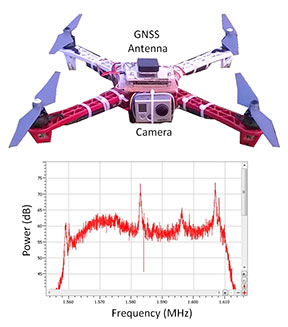 Figure 1 shows what happened to the GPS L1-band spectrum when a GoPro camera was installed on a quadcopter close to the GNSS antenna without sufficient shielding. The three peaks are exactly 24 MHz apart. This points to their being harmonics of a 24 MHz signal: the typical frequency for a MMC/SD logging interface.
An AsteRx4 receiver, which includes the AIM+ system, was selected for this setup. As well as mitigating the effects of interference, AIM+ includes a spectrum plot to view the RF input from the antenna in both time and frequency domains.
At the installation stage, the ability to view the RF spectrum is an invaluable tool for identifying the source of interference. Plus, it helps with determining the effectiveness of measures such as modifying the setup or adding shielding.
For the quadcopter installation in this example, the loss of RTK was readily diagnosed. The problem was solved by placing the camera in a shielded case. All this while the quadcopter was still in the workshop.
GNSS receivers on-board UAVs can be particularly vulnerable to external sources of interference, be they intentional or not. In the sky, the signals from jammers can propagate over far longer distances than they would on land.
In the case of UAV inspections of wind turbines for example, many countries encourage the construction of windmills next to roads. However, this situation increases the chance of interference from in-car chirp jammers.
Though illegal, chirp devices are cheap and readily available on the internet. For example, an individual using a chirp jammer can drive around undetected by the GPS trackers on the vehicle. Car thieves can disable GPS anti-theft devices on stolen vehicles with chirp jammers.
Although transmitting with a power of around 10 mW, chirp jammers are powerful enough to knock out GNSS signals in a radius of several hundred meters on land. In the air, unhindered by trees, building or other obstacles, these jamming signals have a far greater reach. Thus, the UAV is much more vulnerable to interference.
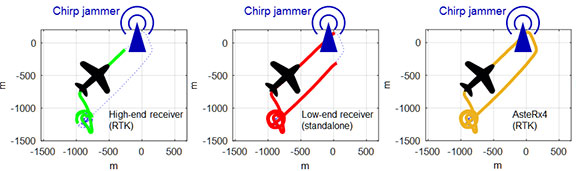 Figure 2 shows how a 10mW chirp jammer can knock out RTK positioning over more than 1 km in a high-end receiver.
Even a low-end consumer-grade L1 receiver, being less accurate and thus less sensitive, loses stand-alone positioning over several hundred meters.
With AIM+ activated, the AsteRx4 is able to maintain an RTK fix throughout the simulated flight. It also shows no degradation to its position variance.
A comprehensive approach puts interference considerations at the forefront of receiver design and incorporates it into every stage of signal processing. In the case of the AsteRx4 and AsteRx-m2, the antenna signal is immediately digitized after analogue filtering and automatically cleansed of interference using multiple adaptive filtering stages.
As each interfering signal has its own individual footprint, the ability to visualize the RF signal in both time and frequency domains allows drone users to identify sources of self-jamming and adapt their designs accordingly before the drone gets in the air.
When it is in the air, AIM+ is able to mitigate jamming from external sources: a set of configurable notch filters are complemented by an adaptive wide-band filter capable of rejecting more complex types of interference such as that from chirp jammers, frequency-hopping signals from DME/TACAN devices as well as high-powered Inmarsat transmitters.
You can shop Septentrio’s line of solutions at Unmanned Systems Source.
