
FT205 Sensor Helps Map Urban Canyons
Urban Air Mobility (UAM) represents a new era in air transportation.
The goal of UAM is to develop a safe and efficient air transportation system. Within this system, everything from small package delivery drones to passenger-carrying air taxis safely and efficiently operate over towns and cities.
However, before UAM is declared fully viable in populated areas, government, industry and academic partners are researching its practicalities.
Urban Canyons
Drones are currently in use in relatively underpopulated rural areas. However, cities are an entirely different matter.
One of the challenges? Cities have very different terrains. Building lined streets create “urban canyons”. The effect of these ‘urban canyons’ on drone operations is not yet fully understood.
For example, a breeze funneled into the relatively narrow gap between buildings, can dramatically increase wind speed. As well, the heat from city surface temperatures can produce unexpected thermals.
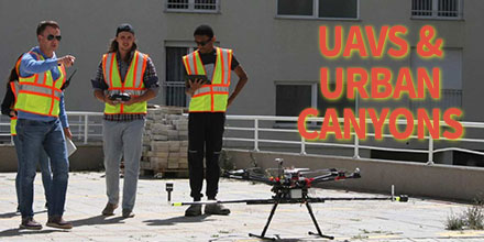
To study such urban canyon effects, a team from Embry-Riddle Aeronautical University and Gaetz Aerospace Institute took off to Kosovo.
Acquiring permission to fly in a densely populated area in the United States was going to be a challenge. So the team identified Kosovo as an alternative.
The Test
The team flew the DJI S1000, an eight-motor ‘octocopter’ drone, in two cities – Janjeva and Prishtina.
They rigged the drone with special instrumentation including two FT205 sensors. The team mounted the sensors orthogonally to measure both horizontal and vertical wind fluctuations.
Temperature, humidity and air pressure were also measured.
The team – combining wind speed, direction and temperature information gained from the anemometers along with aerial photos captured by the drone – generated 3D models showing 3D wind components.
The Results
With the help of the FT205 sensors, the team measured the wind turbulence in an urban canopy. This information is hugely helpful to companies looking into urban air mobility.
This data improves understanding of an aircrafts flight environment in urban areas.
“Within the atmospheric ‘boundary layer’ in cities, the wind constantly shifts as it flows over hot asphalt, followed by cooler green spaces, water-filled canals, and structures of various shapes and sizes,” said Dr. Kevin Adkins, Associate Professor of Aeronautical Science at Embry-Riddle Aeronautical University. “To map those unseen changes, researchers have traditionally simulated urban environments in wind tunnels or with computer models. For the first time, Embry-Riddle faculty and students have captured real-world data to create a three-dimensional map of drone routes.”
Covers new ground
“Nobody else has been studying the urban atmospheric boundary layer in this particular way,” said Adkins. “Many companies are now working on drone-based package delivery, infrastructure inspection and urban air mobility. We need a better understanding of airflows and microclimates in cities so that these new technologies can operate as safely as possible.”
Find out more about the study.
“We were able to make multiple urban boundary layer measurements, right smack downtown in Prishtina, in an urban canyon with 14-story buildings on either side.”
“The FT205 wind sensors were perfect for our operations. Their light weight and accurate measurement contributed immensely to the success of the project. The sensors have been on the road, traveled halfway round the world and back again, and have stood up well!”
Shop FT Technologies line of drone and pole mounted sensors at Unmanned Systems Source.
 Battery life.
This continues to be one of the biggest challenges for drone operators.
Currently, the average flight time of most consumer drones is limited to around 20 minutes. Of course, this number varies depending on many things - weather conditions, payload, etc.
Ultimately, though, battery life continues to be a challenge for long flight operations. Eventually, a drone must return and recharge or switch out batteries before operations can continue.
Battery manufacturers, of course, continuously work to improve battery technology. But, there may be a completely new solution on the horizon...hydrogen fuel cells.
Recently, researchers in Sydney, Australia, successfully conducted UAV test flights using hydrogen-powered fuel cells. The results were promising.
Battery life.
This continues to be one of the biggest challenges for drone operators.
Currently, the average flight time of most consumer drones is limited to around 20 minutes. Of course, this number varies depending on many things - weather conditions, payload, etc.
Ultimately, though, battery life continues to be a challenge for long flight operations. Eventually, a drone must return and recharge or switch out batteries before operations can continue.
Battery manufacturers, of course, continuously work to improve battery technology. But, there may be a completely new solution on the horizon...hydrogen fuel cells.
Recently, researchers in Sydney, Australia, successfully conducted UAV test flights using hydrogen-powered fuel cells. The results were promising.
 In recent years, it’s fair to say that drones have come a long way in terms of mainstream acceptance.
From the initial skepticism of both the ordinary public and commercial entities, drones moved beyond niche hobbyists to one of the most in-demand technologies.
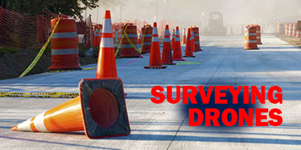
Now, the technology is disrupting the road construction industry, as well.
In recent years, it’s fair to say that drones have come a long way in terms of mainstream acceptance.
From the initial skepticism of both the ordinary public and commercial entities, drones moved beyond niche hobbyists to one of the most in-demand technologies.
Now, the technology is disrupting the road construction industry, as well.
 The race to develop vehicles powered by clean energy is well on its way. Currently, electric and hybrid cars are readily available on the market. As for drones, most already rely on "clean energy" in the form of lipo batteries, to operate.
Solar energy is one sector, however, where exploration is still in its infancy.
Recently, researchers from the Autonomous Systems Laboratory and Glaciologists from ETH Zurich collaborated on a special project: Sun2Ice. The goal? Develop a solar-powered drone and test its ability to monitor glaciers over the vast expanse of the Arctic.
Given the size and immensity of glacial landscapes, the challenge for scientists was designing a vehicle that offered extended flight times. To accomplish this, the team looked to harness the power of the sun.
The end result was AtlantikSolar, a UAV equipped with solar panels that allowed it to stay aloft for days.
The race to develop vehicles powered by clean energy is well on its way. Currently, electric and hybrid cars are readily available on the market. As for drones, most already rely on "clean energy" in the form of lipo batteries, to operate.
Solar energy is one sector, however, where exploration is still in its infancy.
Recently, researchers from the Autonomous Systems Laboratory and Glaciologists from ETH Zurich collaborated on a special project: Sun2Ice. The goal? Develop a solar-powered drone and test its ability to monitor glaciers over the vast expanse of the Arctic.
Given the size and immensity of glacial landscapes, the challenge for scientists was designing a vehicle that offered extended flight times. To accomplish this, the team looked to harness the power of the sun.
The end result was AtlantikSolar, a UAV equipped with solar panels that allowed it to stay aloft for days.
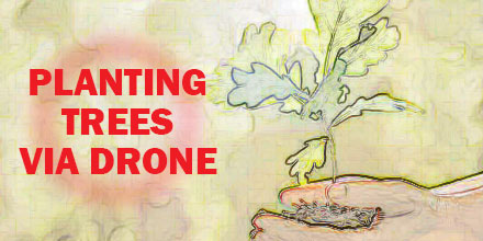 A former NASA engineer is harnessing the potential of drone technology for a very ambitious project.
The project? Ecosystem restoration.
More precisely, scaling reforestation projects to a size previously unimaginable.
The goal? Plant 1 billion trees every year...via drone.
Lauren Fletcher spent 20 years at NASA as an engineer before founding BioCarbon Engineering. The startup's entire focus is reforestation. More precisely, reforestation via the use of drones.
BioCarbon Engineering plans to combat deforestation and restore global forests with a unique solution. Their platform takes the best data available and enables local specialists to restore their landscapes both quickly and affordably.
A former NASA engineer is harnessing the potential of drone technology for a very ambitious project.
The project? Ecosystem restoration.
More precisely, scaling reforestation projects to a size previously unimaginable.
The goal? Plant 1 billion trees every year...via drone.
Lauren Fletcher spent 20 years at NASA as an engineer before founding BioCarbon Engineering. The startup's entire focus is reforestation. More precisely, reforestation via the use of drones.
BioCarbon Engineering plans to combat deforestation and restore global forests with a unique solution. Their platform takes the best data available and enables local specialists to restore their landscapes both quickly and affordably.
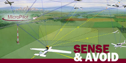 MicroPilot announced the successful integration of FLARM’s Sense and Avoid system with its autopilot.
This integration grants clients a reliable autonomous collision avoidance option for fully autonomous UAV operations.
With any form of autonomous vehicle, a primary concern is safely avoiding collisions with other craft...without the need for human intervention.
A sense and avoid system allows a UAV to do exactly that. Thus, it dramatically reduces operational risks and the need for human monitoring.
MicroPilot announced the successful integration of FLARM’s Sense and Avoid system with its autopilot.
This integration grants clients a reliable autonomous collision avoidance option for fully autonomous UAV operations.
With any form of autonomous vehicle, a primary concern is safely avoiding collisions with other craft...without the need for human intervention.
A sense and avoid system allows a UAV to do exactly that. Thus, it dramatically reduces operational risks and the need for human monitoring.
