In recent years, it’s fair to say that drones have come a long way in terms of mainstream acceptance.
From the initial skepticism of both the ordinary public and commercial entities, drones moved beyond niche hobbyists to one of the most in-demand technologies.
Now, the technology is disrupting the road construction industry, as well.
Drones and road construction
With the advancement in sUAS coupled with lowered cost, drones use continues to expand into more and more applications.
In most cases, drones offer improved efficiency in data collection. Plus, UAVs reduce operational costs by replacing manned aircraft needs and streamlining operations. In addition, drones access environments that may be inaccessible or dangerous for personnel.
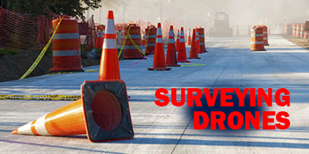
Now, drones are expanding into a new application: road construction and paving projects. This application expansion paves the way for greater efficiency and reduced costs for the industry. In addition, thanks to ever improving software, drones provide precise data collection, as well.
Detailed 3-D survey maps depicting topography, utility lines, drainage slopes, existing hazards -- plus, high resolution images and video -- efficiently secures the data required for building plans and blueprints.
This new tool-set may transform the industry.
The benefits
Cost reduction may be one of the biggest drivers for the wide spread adoption of drone use in the road construction industry.
After all, large infrastructure projects require tremendous sums of money. Any cost savings are welcome.
For instance, replacing manned survey aircraft with a properly equipped fleet of drones. Furthermore, drones offer capabilities such as lower flight altitudes, hovering functions, and more.
Additionally, training and licensing drone operators is less expensive and quicker than securing a pilots license.
The use of the technology is not limited to large multinationals and governmental agencies. Privately run construction companies benefit, too. Improved efficiency allows for faster project completion and the ability to move onto new ones.
Drone technology also helps improve the safety of construction sites. A drone can replace risky operations such as manned aircraft or abseiling crews.
Future application adoption
Drone use for road construction surveying is still in its infancy. And, though governmental legislation lags behind the technology, construction companies continue to adopt this technology. The future for survey drones is very bullish, indeed.
