Tag - UAS

PingStation makes its debut from manufacturer uAvionix

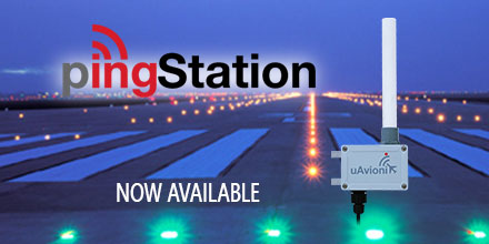
uAvionix Corporation, the leading Unmanned Aircraft System (UAS) avionics solution provider, recently announced the introduction of PingStation. PingStation is an all-weather, networkable ADS-B receiver for low and high altitude aircraft surveillance. Additionally, it is robust enough to permanently mount outdoors in harsh environmental conditions. It is also small enough for use as a mobile asset for roaming operations.

PingStation debut application

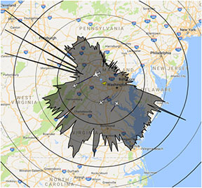
In its debut application, PingStation is a component in Phase 1 of Project UAS Secure Autonomous Flight Environment (U-SAFE). This program is part of a low-altitude Beyond Visual Line of Sight (BVLOS), Unmanned Traffic Management (UTM) corridor. This corridor extends from Griffiss International Airport to Syracuse, NY. A grant from Empire State Development Corporation provides funding for Project U-SAFE. Additionally, PingStation provides ADS-B receiver capability for the Gryphon Sensors Mobile UTM System – Mobile SkyLight.  

Features of PingStation

PingStation is a dual band (978MHz and 1090MHz), networkable ADS-B receiver with a Power-Over-Ethernet (PoE) interface enclosed in an IP67 rated protective enclosure. Integrated is the TSO certified uAvionix FYX GPS receiver for high-resolution time-stamping for critical applications. It provides ground, surface, or low-altitude ADS-B surveillance within line of sight of the antenna, with ranges exceeding 250NM depending on the transmission power. PingStation has multiple uses within the aviation industry:
  • Unmanned Traffic Management (UTM) systems
  • A component of UAS Ground Control Stations (GCS)
  • A component of UAS Detect and Avoid (DAA) systems
  • Airport surface and region situational awareness
  • FBO/flight school fleet tracking and management
Multiple subscription free software/data interface types allow easy integration directly into end applications such as UAS ground control stations, airport surface displays, or cloud-based situational awareness applications. Natively, PingStation provides integration into Virtual Radar Server, an open-source situational awareness mapping display system, the Kongsberg Geospatial IRIS UAS Airspace Situational Awareness Display, and INDMEX Aviation’s Airboss airport situational display suite.
PingStation Range Plot in Virtual Radar Server showing 50NM Range Rings.
“uAvionix is excited to add PingStation to our product line of ADS-B transceivers and receivers,” said Paul Beard, CEO of uAvionix. “Our customers informed us for the need of robust and low-cost surveillance solutions to complement the airborne equipment used in their operations.”   Shop uAvionix entire line of ADS-B products, including the PingStation, at Unmanned Systems Source.  

About uAvionix Corporation

uAvionix develops the world’s smallest, lightest and most affordable ADS-B transceivers, transponders, and GPS receivers. Based in Palo Alto, uAvionix has gathered a cross-disciplinary team of experts in embedded RF engineering, sUAS operations, avionics, hardware, software, and cloud services.

MicroPilot autopilot solutions now available at Unmanned Systems Source

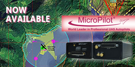
April 4, 2017 – Unmanned Systems Source is pleased to announce a new distribution partnership with MicroPilot, producers of full-featured UAV autopilots. “MicroPilot is a world leader in small autopilot systems for UAS,” said Drew Osbrink, Business Development Director for Unmanned Systems Source. "The MicroPilot product line is a great fit for customers looking for a reliable solution to manage complex autonomous behaviors for their UAS platforms,” said Osbrink. Introduced in 2004 and weighing only 28 grams, MicroPilot's MP2x28g2 raised the bar around the world for functionality and value in small UAV autopilots. Paired with this full-feature UAV autopilot, the MicroPilot HORIZONmp ground control software provides a user-friendly, point-and-click interface for mission planning, parameter adjustment, flight monitoring, and mission simulation. Building on the success of these proven innovations, MicroPilot now offers a series of autopilots, software, accessories, and customized UAV training and integration services.  

MicroPilot autopilot solutions

  • Small size without sacrificing functionality: 28 grams, 4 cm by 10 cm
  • GPS waypoint navigation with altitude and airspeed hold
  • Completely independent operation, including autonomous takeoff, bungee launch, hand launch, and landing
  • Powerful script language command set
  • Open architecture – all state fields fully accessible
  • Fully integrated with 3-axis gyros and accelerometers, GPS, pressure altimeter, pressure airspeed sensors, all on a single circuit board
  • Extensive data logging and telemetry capabilities
  • UAV configuration wizard and installation video simplify installation
  • Includes HORIZONmp ground control software
 

Seamless upgrade path

From the single-use autopilot (MP2x28xp) to the powerful VTOL autopilot (MP2128HELI), MicroPilot provides a seamless upgrade path. No other autopilot manufacturer offers this high degree of adaptable technology and range of autopilot options. Once an individual learns how to operate a MicroPilot autopilot, the knowledge translates across the product line. This makes MicroPilot the single-vendor solution for autopilot hardware, software, and accessory needs. MicroPilot’s line of autopilots allows customers to grow and adapt at a fraction of the cost offered by many competitors. Visit Unmanned Systems Source to learn more about MicroPilot's autopilot solutions.  

About MicroPilot

Incorporated in 1994, MicroPilot serves UAV manufacturers who maintain high standards for both the hardware they integrate into their systems and the software that drives them. MicroPilot customers require products that are reliable, scalable and customizable. They have a solid reputation that supplies consistent products, services and support. MicroPilot has maintained itself as the world leader in professional autopilots for UAVs and MAVs.

Apple May Harness Drone Technology To Improve Apple Maps Accuracy

Apple has supposedly begun work on a drone-powered alternative to keep their Apple Maps service up to date and faster that their current fleet of sensor and camera-outfitted vans and vehicles. According to a report by Bloomberg Technology, Apple intends to use drones to examine street signs and track changes to streets and roads. Additionally, the report indicates that monitoring construction projects is also a major goal of the project, which has not yet been fully approved by the FAA. While Apple usually does not respond to inquiries regarding future plans and technologies they will be using, there was an FAA exemption granted on March 22, 2016 for Apple to "operate an unmanned aircraft system to conduct data collection, photography, and videography". In the application, Apple stated they would be using many different drones from DJI, Intel, and Parrot, with data collection services managed by a company called Aibotix GmbH. In the application, Apple also addressed potential safety hazards of using the drones and how they intend to mitigate the risk:
The proposed operations do not create any hazard to users of the NAS or pose a threat to national security. The Aircraft are battery operated with a maximum flight time of less than 25 minutes. The Aircraft weigh less than 55 pounds. The Aircraft will be operated at or below 400 feet AGL within the visual line of sight of the pilot in command. UAS operations will be over private or controlled access property with the permission of the owner/controller or authorized agent.
You can read the full FAA exemption filed by Apple here. If Apple begins mapping efforts as intended, they may face some obstacles considering that current FAA exemptions still do not allow you to fly over people or roads. How Apple intends to navigate around these restrictions is still up in the air (no pun intended). Digital maps are essential to both the Apple and Google ecosystems, with consumers and developers alike both relying on the accuracy of the maps to travel to and from locations, and develop applications that use the map features. Accuracy is key, and if Apple can improve its current mapping efforts to match or beat Google, they will be well positioned for growth and user adoption.

Wildfire Operations & Temporary Flight Restrictions

wildfire_T"Know Before You Fly" Urges Operators to Stay Away from Wildfires, Adhere to Temporary Flight Restrictions 

WASHINGTON — The Know Before You Fly campaign today urged operators of unmanned aircraft systems (UAS) to respect temporary flight restrictions (TFRs) over and around wildfires as this year’s wildfire season makes an early start.

Wildfires or other hazardous conditions often lead to authorities putting in place TFRs, which allow first responders to do their jobs unimpeded and without danger to their aerial support.

Temporary Flight Restrictions

Violating the TFR may endanger the safety of the operation, and in some cases may ground search and rescue crews until the airspace is cleared, allowing the wildfire to spread. But TFRS do not just apply to wildfires.

For stadium events ranging from concerts to NASCAR races to the Super Bowl, model aircraft flights and unmanned aircraft operations are generally restricted. More information about the types of TFRs may be found here.

To check for TFRs in your area, visit the FAA TFR list at http://tfr.faa.gov/tfr2/list.html. Additionally, download the FAA’s B4UFLY app, available on the App Store or Google Play, to find up-to-date information on TFRs.

No one should be flying within a TFR that restricts UAS and/or model aircraft operations.

Standard flight guidelines for operators

At all other times when flight is permitted, Know Before You Fly would like to remind recreational flyers to follow these guidelines to keep the skies safe for all:

  • Fly no higher than 400 feet
  • Fly within visual line of sight
  • Stay well clear of other aircraft
  • Never fly within 5 miles of an airport without contacting airport authorities or air traffic control
  • Keep well away from emergency response efforts, such as fires
  • Beware of FAA airspace requirements (http://www.faa.gov/uas/tfr/)
  • Don’t fly under the influence
  • Register your device before your first flight (http://knowbeforeyoufly.org/register-your-drone/)

If you are flying for commercial purposes, please adhere to the FAA small UAS regulations, which can be found here.

Know Before You Fly was launched by the Association for Unmanned Vehicle Systems International (AUVSI) and the Academy of Model Aeronautics (AMA) in partnership with the FAA with the goal of spreading awareness about safe and responsible use of UAS. For more information on safe and responsible flying, visit KnowBeforeYouFly.org or follow @FlyResponsibly on Twitter.