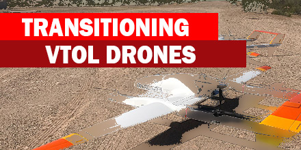
 Recently, MicroPilot announced that their autopilot now supports transitioning VTOL drones.
MicroPilot autopilots already fly a wide range of UAVs, including: fixed-wings, multi-rotors, helicopters and even tail sitters.
Now, manufacturers of transitioning UAV drones have the option of a professional autopilot known for its reliability.
Transitioning drones benefit from the many options that come standard with MicroPilot autopilots. The MicroPilot’s HORIZONmp ground station software features a built-in VTOL simulator. This simulator helps speed up the learning curve and provides an operator training mode.
The MicroPilot’s XTENDERmp software development kit also enables customers to differentiate themselves from other transitioning drone manufacturers. In addition, MicroPilot’s trueHWIL2, the highest fidelity simulator in the industry, also supports transitioning drones.
“I’m very pleased that we now have a solution for our customers that want to fly transitioning VTOL drones,” said Howard Loewen, President of MicroPilot. “As the industry matures, high reliability professional products are more important. Manufacturers of transitioning VTOL drones can now choose an autopilot designed with the professional in mind.”
Drone manufacturers choose professional grade autopilots to ensure high quality and reliability. MicroPilot’s professional grade autopilots are subject to 100% environmental stress screening. In addition, they also go through multi-point calibration and testing during the manufacturing process. This ensures that all of MicroPilot’s autopilots offer consistent performance and outstanding reliability.
By supporting transitioning drones, MicroPilot demonstrates its ongoing efforts to support a wide range of UAV. MicroPilot continues to adapt to the constant changes of an increasingly high-tech world. As new UAVs appear, MicroPilot works to ensure customers have the option of choosing a high-reliability autopilot.
Started in 1994, MicroPilot is the world leader in professional autopilots for UAVs and drones. An ISO 9001 certified autopilot manufacturer, MicroPilot markets single-board autopilots, enclosed autopilots, and a triple redundant autopilot. MicroPilot offers a family of lightweight UAV autopilots that can fly fixed wing, transitional, helicopter, and multirotor UAVs.
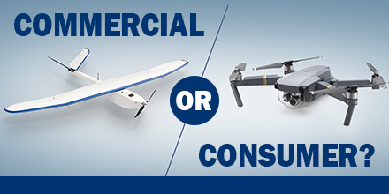 Is there a difference in the accuracy of survey data from a consumer “retail” system versus a commercial system? If so, what is that difference?
Over the Summer, the team at Altavian — manufacturer of the Nova F7200 — decided to find out.
For a variety of application, including aerial data collection, commercial UAV systems are believed to far exceed the capabilities of a retail drone. However, few surveyors have the luxury of comparing a commercial versus a consumer platform in a real-world environment.
So, the Altavian Team decided to run a data collection survey test between a DJI Mavic Pro and an Altavian Nova F7200.
The end result? The Nova F7200 produced data ten times more accurate than the Mavic in both horizontal and vertical deviation.
Establishing a reliable control for data comparison was a critical aspect of the experiment. The team decided on a traditional ground survey to serve as the data control baseline. Below is an overview of the ground survey.
Equipment used
Survey Description
This survey established ground control for comparing the survey accuracy of drone data collected by a DJI Mavic Pro and Altavian’s Nova F7200 equipped with an MP-22 payload.
Collection of Control
The rover was placed on both the South Points for four hours each. The resulting coordinate error are LAT error at .005 m., LONG error .009 m., and ELEV error .033 m. (point 1). For (point 2) LAT error at .006 m., LONG error at .021 m., and ELEV error at .042 m.
Survey Procedure
The survey points were 8’’ spikes driven through checked linoleum tiles. The points were shot using a Leica TCR405 total station. The elevations were collected using a Leica Sprinter.
Survey Results
The vertical survey ended with a misclosure of .0095 m.
Each aircraft collected two sets of data which the team compared to With previously established Ground Control Points (GCP) from the ground survey, there was a clear way to determine how the accuracy of consumer and commercial systems stacked up.
The team’s primary concern was to ensure that the smaller, consumer system had the same GSD as the Nova. To ensure this, the Mavic flew just shy of 60 m. to maintain a calculated GSD of 1.97 cm.
The Mavic Flight used 317 photos with a median of 51976 key points per image, and a median of 30452.2 matches per calibrated image. The total flight time for the Mavic was 25 minutes.
The data was processed in Pix4Dmapper Pro and then compared to the results from the ground survey. The result was the Mavic had a deviation from the GCPs at 1.9 m. horizontally and 1.22 m. vertically. Finally, the mean RMS error for the Mavic was 0.996 m.
Thet team equipped the Nova with their modular MP-22 payload carrying a DSLR Canon SL1 camera.
It flew at its standard 90 m. altitude maintaining a GSD of 1.97 cm. The Nova Flight used 238 images with a median of 40199 key points per image, and a median of 25492.3 matches per calibrated image. Total flight time for the Nova was 9 minutes. The data process using Pix4Dmapper Pro was identical to create a comparable data sets between the Mavic and Nova.
Once again, the team compared the data to the ground survey. They found that the Nova had a 0.19 m. horizontal and 0.17 m. vertical deviation from the GCPs. The mean RMS error for the Nova was 0.015 m.
When the team examined the two data sets against the accuracy of the ground survey, it revealed a clear winner. The Altavian commercial system thoroughly out paced the consumer system.
Now, the benefits of investing in a commercial system were measurable. Also measurable were the risks involved in selecting a consumer drone for such a task.
Though consumer drones are a great fit for a number of applications, there are risks involved when choosing such a vehicle for other endeavors. An off-the-shelf consumer drone offers an attractive price tag. However, that price tag also comes with limitations when it comes to the accuracy and fidelity of data that, ultimately, makes it more toy than tool.
The advantages of a commercial system like the Nova F7200 for accurate survey data are clear. In the long run, such systems are a safer long-term investment.
Commercial drones designed for survey accuracy cut workload down from weeks to days. Such systems enable users to complete projects faster and with more cost efficiency. And, such systems beat the pants off walking that survey line day in day out rain or shine.
Find out more about Altavian’s commercial line of solutions at Unmanned Systems Source.
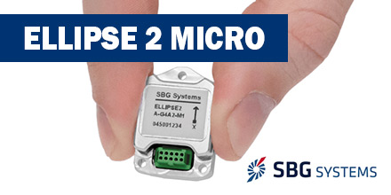 Recently, SBG Systems announced the releases the Ellipse 2 Micro Series. This new product line reduces the size and cost of high performance inertial sensors for volume projects.
“With the Ellipse 2 Micro, integrators benefit from SBG Systems high expertise in motion sensing and positioning in the smallest package,” said Alexis Guinamard, CTO of SBG Systems.
The new Ellipse 2 Micro is available as an IMU for calibrated sensor data, or as an AHRS/INS delivering accurate orientation and navigation using an external GNSS receiver.
Combining state-of-the-art MEMS-based gyroscopes, accelerometers, and magnetometers, it is establishing new standards in micro MEMS IMU accuracy and reliability.
Following the extensive SBG production process, the Ellipse 2 Micro Series is fully calibrated in temperature. This calibration process eliminates measurement errors such as: sensor bias, gain, linearity, alignment, and g-sensitivity. As such, it provides a constant behavior in all conditions.
Plus, the high-quality Ellipse 2 Micro benefits from a 2-year warranty.
SBG Systems has been manufacturing inertial sensors for more than 10 years. The company is especially recognized for the added value of the embedded algorithms.
The R&D team continues to adjust motion profiles to platforms (UAV, car, vessels, etc.) and specific conditions (vibrations, high dynamics, low motion, etc.) to reach the highest reliability.
Weighing only 10 grams, the Ellipse 2 Micro benefit from this high expertise. It provides a 0.1° accurate attitude and connects to external GNSS for navigation. It offers a remarkable weight/performance ratio to integrators.
Ellipse 2 Micro Series provides excellent navigation data when connected to an external GNSS receiver. The cost-effective Ellipse2 Micro INS fuses in real-time inertial and GNSS information to maintain the vehicle position in air, marine, or in land applications.
For automotive projects, the inertial sensor comes with CAN protocol and connects to odometer for an even higher performance in harsh environments (tunnel, urban canyons, etc.).
In addition, the Ellipse 2 Micro is the smallest sensor to provide Heave which automatically adjusts to the wave frequency.
With accurate orientation, navigation, and heave features, Ellipse 2 Micro Series is a remarkable sensor for motion monitoring, wave measurement, stabilization and orientation of onboard equipment (camera, antennas, side-scan echo sounders, etc.).
All Ellipse 2 Micro models are now available for order. Product and pricing information is available from Unmanned Systems Source.
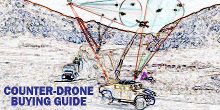 Department of Homeland Security’s SAVER program recently identified 13 counter-unmanned aerial systems that could be useful for emergency response.
To accompany this announcement DHS also issued a guide on their features to assist procurement.
National Urban Security Technology Laboratory (NUSTL) SAVER program conducted the market survey of counter-unmanned aerial systems to help emergency responders identify useful products.
The SAVER program is designed to help emergency responders make procurement decisions. SAVER conducts operationally orientated assessments of equipment and then releases the information.
Responders use that information to select, procure, use and maintain the equipment.
Its Counter-Unmanned Aerial Systems (C-UAS) Market Survey identified 13 such products and weighed their benefits and suitability for specific purposes.
A C-UAS can detect, track, mitigate or classify a SUAS (small unmanned aircraft system) that is in the area.
The use of SUASs for both legitimate and unauthorized purposes is on the rise, leading to a flurry of campaigns and new regulations from the FAA in recent years. The study states that most of the SUAS-related incidents reported to law enforcement involve the unintentional misuse of SUAS, and pose safety rather than security risks.
As such, the products described in the market survey offer responders the ability to track and/or mitigate SUAS that could pose a threat to public safety and critical infrastructure.
The 13 systems vary in price, ranging from $7,500 to $1.9 million.
At the top end of the scale is a 500-pound, anti-UAV defense system from Liteye Systems, which consists of a radar sensor, EO suite and a directional RF inhibitor. It can detect, track, classify and mitigate SUAS by selectively interfering with its C2 channels. The stationary variant attaches to a vehicle or a mast. It includes a thermal camera and a video tracker.
Closely behind in price is the Sky Tracker from CACI international. This fixed system covers large areas by networking several systems together. The Sky Tracker uses proprietary algorithms to track and classify SUAS. The system’s RF jammer emulates SUAS signals to hijack the command and control system. Thus, preventing communication with the pilot on the ground.
Additionally, there are also options for first responders who need C-UAS that detect and classify but don’t mitigate SUAS. The study outlines the features of the Elvira from Robin Radar Systems and the UAVX from Spotter RF.
The 183-pound Elvira costs in excess of $160,000. It combines detection and classification in just one sensor, using color-coded tracks overlaid on Google Earth and then layered on a customized map. No price is listed for the UAVX, which uses video tracking and tracks SUAS in real time.
At just $7,500, the least expensive product surveyed is the Excipio Net Gun from Theiss UAV Solutions and Carolina Unmanned Vehicles. Excipio Net Gun is solely for mitigating SUAS. It accomplishes this by launching a net to either ensnare the SUAS or launching it to another location.
Of the 13 C-UAS listed, eight can detect, track, classify and mitigate SUAS. Two are just for detection, tracking and classification and three are used to mitigate only.
Before making procurement decision, the report encourages responders to know the laws in their jurisdiction which may prohibit the use of certain C-UAS features.
Access the full guide here.
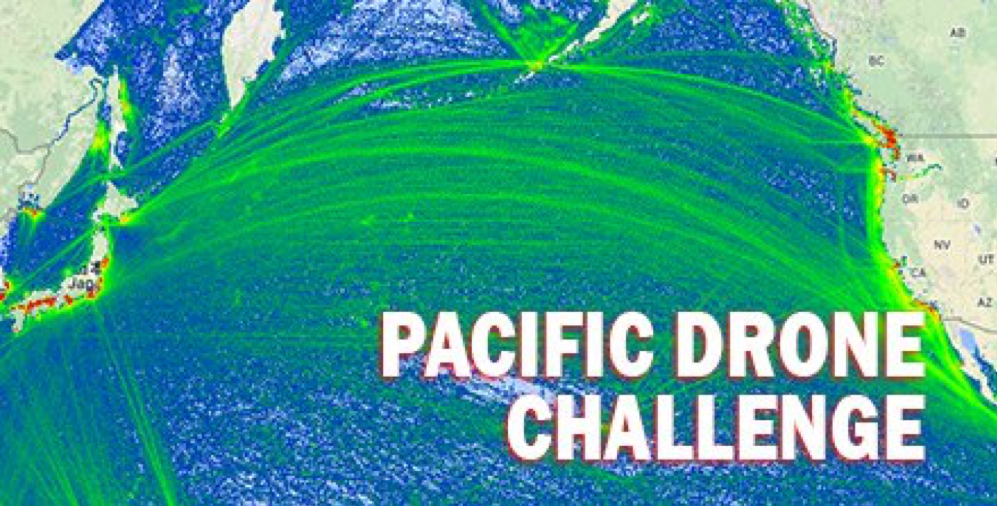 What lies between the Pacific coasts of Japan and Silicon Valley?
About 4,500 miles of ocean, of course! A distance easily traveled by commercial airlines but certainly beyond the reach of non-military drones.
But is that about to change?
Yes. If, that is, a winner emerges from the Pacific Drone Challenge.
This new competition challenges pilots and scientists around the world to fly a UAV from Japan to Silicon Valley, California. Furthermore, as the flight must be non-stop, there is no chance to refuel.
This event is a daunting 4,500 mile challenge for all technology innovators. And, though such a challenge seems beyond current capabilities, it is viewed as a way to extend possibilities and the reach of technology. Much as Charles Lindbergh’s historic flight across the English channel did for aviation.
The contest is open to participants around the world and there is no deadline. The winner is the first team to successfully take off from Japan and land safely in Sunnyvale, California.
Currently, the Pacific Drone Challenge is more of a “what if” question than a formal competition. The 4,500 distance extends well beyond the reach of current non-military drones.
As of yet, the competition is not offering any prize money for winning teams.
So far, competing teams include the Japanese tech company, iRobotics, and the American aircraft company, Sabrewing. Both are sponsors of the challenge
If a team successfully complete the challenge, the new technology developed for such an adventure may just benefit the entire industry. Certainly, a commercial drone — at a fraction of the size, weight and cost of other aircrafts – that can fly 4,500 miles non-stop offers significant benefits.
Find out more about the Pacific Drone Challenge.
 The past decade witnessed the explosion of drone technology and the widespread adoption of this technology for numerous applications.
The use of UAVs is varied — from construction and agriculture to videography and real estate — and applications continue to expand.
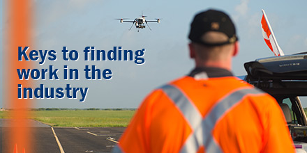
This burgeoning industry has left many wondering if a passion for flight could evolve into an exciting career.
However, the path to becoming a professional drone pilot takes diligence and planning. So, for an experienced drone pilot, how easy is it to set up business and watch the money roll in?
A Remote Pilot Certificate is vital. FAA approval is required if a drone is used for any business purposes. Operating without such certification can result in hefty fines.
A Remote Pilot Certificate, or “drone license”, allows a pilot to legally fly a drone for profit making purposes. The certification process differs between first-time pilots and those who are existing pilots.
First-time pilots must:
For a full list of requirements, visit the FAA website.
Existing pilots:
For a full list of requirements, visit the FAA website.
Of course, there are certain restrictions pilots must follow when operating a drone…even if it is for business purposes. Particular operation also require a 107 waiver – which can take weeks to clear.
Holding the proper certification and understanding the rules governing flight operations are vital.
As drone technology evolves, more and more niche applications arise. As such, a great starting point is to identify the niches that best suit a pilot’s interest and skill set.
Developing the knowledge and specialized skills needed for a particular sector — aerial cinematography, 3D mapping, precision agriculture — is one approach.
And though all involve the use of a drone, payload selection (camera, lens, etc.), information capture and post-processing software are unique to the application. Plus, selecting the right vehicle is vital — not all drones are capable of supporting each mission.
Specialization allows a pilot to gain the knowledge, experience — and optimal equipment — to operate as safely and efficiently as possible. All while producing exceptional results for the client.
Of course, specialization has drawbacks but it is one way a drone pilot can separate themselves from an increasingly populated market.
The number of industries using drones, of course, continues to grow. Some choose to keep all operations in-house while others are outsourcing all flight operations.
Outsourced pilot positions put a premium on pilot competency and tend to require higher levels of professional experience, certification and training.
Those interested in securing such work should place greater emphasis on gaining knowledge, expertise and the proper certifications. a professional reputation in order to be successful.
As UAV applications increase and drone technology improves, the number of opportunities within the market will continue to expand.
Of course, piloting UAVs as a career is an enticing prospect for many amateur drone pilots and enthusiasts. Ultimately, the quality of a pilot’s work is what will differentiate a professional from an amateur.
By Pamela
