Tag - FAA

Unauthorized Drone Operations and DOE Facilities

At the request of U.S. national security and law enforcement agencies, the Federal Aviation Administration (FAA) is using its existing authority under Title 14 of the Code of Federal Regulations § 99.7 – “Special Security Instructions” – to address concerns about unauthorized drone operations over seven Department of Energy (DOE) facilities. The FAA and DOE have agreed to restrict drone flights up to 400 feet within the lateral boundaries of these sites:
  • Hanford Site, Franklin County, WA
  • Pantex Site, Panhandle, TX
  • Los Alamos National Laboratory, Los Alamos, NM
  • Idaho National Laboratory, Idaho Falls, ID
  • Savannah River National Laboratory, Aiken, SC
  • Y-12 National Security Site, Oak Ridge, TN
  • Oak Ridge National Laboratory, Oak Ridge, TN
The airspace restrictions are shown in an FAA Notice to Airmen (NOTAM) and the details about where drone flights are restricted are here.  

Effective December 29

These UAS National Security restrictions are pending until they become effective on December 29, 2017. There are only a few exceptions that permit drone flights within these restrictions. Drone operators must seek exceptions from the individual facility and/or the FAA. To ensure the public is aware of these restricted locations, the FAA created an interactive map online. The link to these restrictions is also included in the FAA’s B4UFLYmobile app. The app will update within 60 days to reflect these airspace restrictions. Additional information, including frequently asked questions, is available on the FAA’s UAS website. Operators who violate the airspace restrictions may be subject to enforcement action, including potential civil penalties and criminal charges. This is the first time the agency has placed specific airspace restrictions for unmanned aircraft, or “drones,” over DOE sites. The FAA has placed similar airspace restrictions over military bases that currently remain in place, as well as more recently issued UAS flight restrictions over 10 Department of Interior facilities, including several large dams and iconic landmarks. The FAA continues to consider restriction requests from other federal security agencies for restrictions using the FAA’s § 99.7 authority to support national security and defense.  

NOTAM Notification

FDC 7/6429 FDC SECURITY SPECIAL SECURITY INSTRUCTIONS FOR UNMANNED AIRCRAFT SYSTEM (UAS) OPERATIONS FOR MULTIPLE LOCATIONS NATIONWIDE. THIS NOTAM SUPPLEMENTS THE UAS-SPECIFIC SPECIAL SECURITY INSTRUCTIONS DEFINED BY FDC 7/7282 AND IMPLEMENTED PURSUANT 14 C.F.R. 99.7 AND HAVE BEEN APPLIED TO AIRSPACE OVER ADDITIONAL NATIONAL SECURITY SENSITIVE FACILITIES. THE UPDATED LIST OF AFFECTED AIRSPACE AND ASSOCIATED PROTECTED LOCATIONS, AND OTHER IMPORTANT INFORMATION ARE PROVIDED AT THE FOLLOWING FAA WEBSITE: HTTP://UAS.FAA.OPENDATA.ARCGIS.COM. SEE FDC 7/7282 FOR COMPLETE INFORMATION ON THESE SPECIAL SECURITY INSTRUCTIONS. 1712290001-1902012359

FAA requests emergency fast-track of electronic drone authorization

It seems the Federal Aviation Administration (FAA) finally reached a breaking point with requests to access restricted airspace. Currently, it can take up to 90-days for an operator to get authorization to navigate controlled airspace. With more and more authorization requests pouring in, the logjam continues to get worse. As such, the speculation is that some operators decide not to wait and fly without authorization. This may explain the increase in the number of non-compliant operations, as reported by the FAA. It is estimated that there are over 250 drone-related safety reports each month.  

Access to restricted airspace

Under 14 CFR 107.41, “no person may operate a small unmanned aircraft in Class B, Class C, or Class D airspace or within the lateral boundaries of the surface area of Class E airspace designated for an airport unless that person has prior authorization from Air Traffic Control (ATC).” Since Part 107 launched, the FAA has received an extremely high volume of airspace authorization requests from UAS operations. From September 2016 to July 2017 the Agency received 20,566 authorization requests. Of these, the Agency processed 14,334. At any given time, there are up to 6,000 authorizations in the processing queue. Additionally, the number of requests continue to increase. The FAA expects the queue will exceed 25,000 pending authorizations within the next 6 months.  

Ongoing efforts by the FAA

The solution? Fast-track the electronic authorization of drone flights. The groundwork for this eventuality has been a work-in-progress for the FAA. The first step came when the FAA implemented Part 107 in August 2016. 
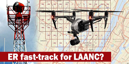
This year, the FAA – in collaboration with airport tower staff – developed and published a series of grids. These grids depict the maximum safe and permissible altitude for unmanned aircraft operations. The FAA published these maps online. The maps serve as the foundation for the Low Altitude Authorization and Notification Capability (LAANC) system. The goal is for LAANC to provide a quick and efficient response to airspace authorization requests.  

Real-time authorizations with LAANC?

When operational, the FAA believes LAANC will help the agency grant “near-real time" authorizations for the vast majority of operations. The FAA states that remote pilots certified under part 107, who submit requests that comport with the published limitations, can expect almost real-time, electronic approval. The system is also vital to the safety of National Airspace. The FAA expects LAANC to reduce “non-compliant” operations by at least 30 percent. Plus, once operational, it reduces distraction of controllers working in the Tower. The FAA’s recent request seeks to accelerate the implementation of LAANC, which was to take until the end of the year. “Due to the pressing safety consideration of reducing safety reports due to non-compliant UAS operations, the FAA cannot wait the normal 90 days of public comment,” the agency stated in the Federal Register notice Oct. 11. “Therefore, FAA is requesting Office of Management and Budget's (OMB) approval of this collection of information 7 days after publication of this Notice in the Federal Register. Upon OMB approval of its Emergency clearance request, FAA will follow the normal clearance procedures for the information collection associated with LAANC.”  

FAA Issues Drone Flight Restrictions Over Certain Landmarks

Recently, U.S. national security and law enforcement agencies made a request of the Federal Aviation Administration (FAA). The request? They asked the FAA to use its existing authority to address unauthorized drone operations over Department of Interior (DOI) sites. The FAA's authority comes from Title 14 of the existing Code of Federal Regulations (14 CFR) § 99.7 – “Special Security Instructions”.  

High profile DOI sites

The FAA agreed with the request. As such, in cooperation with the DOI, the FAA now restricts drone flights up to 400 feet within the lateral boundaries of these sites:
  • Statue of Liberty National Monument, New York, NY
  • Boston National Historical Park (U.S.S. Constitution), Boston, MA
  • Independence National Historical Park, Philadelphia, PA
  • Folsom Dam; Folsom, CA
  • Glen Canyon Dam; Lake Powell, AZ
  • Grand Coulee Dam; Grand Coulee, WA
  • Hoover Dam; Boulder City, NV
  • Jefferson National Expansion Memorial; St. Louis, MO
  • Mount Rushmore National Memorial; Keystone, SD
  • Shasta Dam; Shasta Lake, CA
 

Restrictions now in place

These new flight restrictions took effect October 5, 2017. As always, there are only a few exceptions that permit drone flights within these restrictions. Operators seeking exceptions must coordinate with the individual facility and/or the FAA. The FAA's online interactive map helps ensure the public is aware of the various restricted flight locations. Additionally, the link to these restrictions is included in the FAA’s B4UFLY mobile app. The B4UFLY app should update within the next 60 days to include the new restrictions. Additional information, including frequently asked questions, is available on the FAA’s UAS website. Operators in violation of these airspace restrictions may be subject to enforcement action, including potential civil penalties and criminal charges. This is the first time the agency placed airspace restrictions for unmanned aircraft, or “drones,” over DOI landmarks. The FAA placed similar airspace restrictions over military bases -- which remain in place. The FAA is considering additional requests from vaious federal agencies seeking restrictions using the FAA’s § 99.7 authority.

uAvionix tests dime-sized ADS-B for high traffic density drone operations

uAvionix tests dime-sized ADS-B January 30, 2017 - uAvionix Corporation based in Palo Alto, California continues to innovate within the ADS-B transceiver market. Today, uAvionix announced the development and test of a dime-sized transceiver weighing less than 1 gram. UAvionix worked under a Collaborative Research and Development Agreement with the FAA and other partners to test this prototype.  

Smallest transceiver to-date

This ADS-B module represents the smallest transceiver to date. Its small form factor is designed to integrate directly into professional and consumer-level drones with transmission power between 0.01-0.25 Watts. It could provide visibility to any aircraft equipped with ADS-B “in” avionics from 1-10 miles away. Currently, the product does not fall within current FAA standards due to its low power output transmission.  

Need for uAvionix dime-sized ADS-B

Recently, a study published in January by the MITRE Corporation’s Center for Advanced Aviation Systems Development (CAASD) envisioned a world of very high traffic densities of drones with on-board ADS-B. The study sought to understand the implications of such a scenario. It suggested that there is a nominal transmission power output between 0.01 and 0.1 Watts that, when coupled with limited drone traffic densities, can result in a compatible operation with the system as a whole. uAvionix believes this module is a step towards the future. “We developed this product to show the world the art of the possible,” said Paul Beard CEO of uAvionix. “We can’t yet sell this device because the standards that were developed for ADS-B did not take into account the value of air-to-air ADS-B communications between small drones or between drones and manned aircraft. It’s literally not legal to transmit at these low power outputs. We aim to lead the discussion and development of those standards and will work with any regulatory body to do so.”  

About uAvionix

uAvionix develops the world’s smallest, lightest and most affordable ADS-B transceivers and transponders, Ping. UAvionix’s Ping network system combines hardware, software, and real-time airspace mapping to enable companies to safely and reliably operate drones in the National Airspace System (NAS). Shop the complete line of uAvionix ADS-B products at Unmanned Systems Source.

B4UFLY app helps operators determine legal flight status

B4UFLY app helps operators determine legal flight statusDecember 19, 2016 – With all the new FAA regulations taking affect, many drone operators – professionals and hobbyists, alike – are asking a very important question: “Where can I fly my drone legally?” As you know, the FAA has rules defining where and when commercial operators and hobbyists can fly legally. The rules, of course, differ for each group. To provide clarity, the FAA developed the B4UFLY app to help operators quickly determine where they can fly legally. The app is offered for both iOS and Android systems.

How it works

The B4UFLY app uses the GPS in your phone or tablet to determine your current location on the map. It then uses this information to determine if it is safe and/or legal to fly. The FAA describes the app as, “providing model aircraft users with situational awareness by considering the user’s current or planned location in relation to operational restrictions to derive a specific status indicator.” The color coded status indicators inform operators if flight is prohibited, if action is required of the flyer, or if there are no FAA flight restrictions other than standard safe operation of the craft.

The app also features:

  • Heads-Up Status View for quick “at-a-glance” review of current status
  • Map Interface to plot nearby flight restrictions
  • Planner Mode which helps users “plan” for different flight locations and times
  • More Info which lists helpful links and additional FAA resources
The map function does not allow users to view flight status of locations other than where the device is currently. Though user ratings for the app are low, software updates may resolve some of the ongoing issues. If not, there are several apps available that provide similar information.

Valuable resources

As regulations continue to evolve, apps such as B4UFLY provide flyers with a valuable resource to help them quickly and easily determine if it is safe and legal to fly. Take a look at your options and consider downloading an app that helps you keep your flight time safe, fun and legal. Download the B4UFLY app: Google Play for Andoid or iTunes for iOS.

ADS-B Technology Solutions for Enhanced Aviation Tracking and Safety

What exactly is ADS-B and do I need it?

Automatic Dependent Surveillance – Broadcast (ADS-B) is part of the Federal Aviation Administration's NextGen air traffic control modernization mandate. This mandate requires all aircraft within US airspace to transmit “ADS-B Out” information to ADS-B ground stations and other ADS-B equipped aircraft by 2020. The transmitted information includes aircraft identification, altitude, speed, and velocity - thus, creating a new, real-time situational awareness and surveillance program. Additional system upgrades may allow aircraft to fly outside the typical strict air traffic corridors, thus, introducing more "bandwidth" by expanding into areas that were previously not utilized. Air traffic control towers may also expand into new areas since ADS-B data is available anywhere over the internet. Currently, several countries utilize ADS-B, including Canada and Australia, with Europe and Asia rolling out their own systems in the coming years. With the mandate looming, many pilots are looking for affordable ADS-B technology solutions they can integrate into their setup.  

How does it all work?

The ADS-B system is comprised of multiple parts, including ground stations and aircraft installed equipment.  The ADS-B equipment package installed on the plane includes a GPS unit for providing location information, processing hardware, and antennas for transmitting and receiving the ADS-B signals. ADS-B receiver ground stations pick up ADS-B information broadcast by aircraft flying over head. This information is used by air traffic controllers as a supplement to radar-based tracking. Airspace safety should improve by giving pilots and air traffic controllers additional information about the position of each aircraft in the system, which should help prevent mid-air collisions or close calls during takeoff and landing. As systems such as ADS-B come on-line, existing flight corridors should safely handle an increasing number of daily flights by adding accuracy and redundancy to the existing airline tracking systems.  

Simplified ADS-B Network Example

ADS-B Technology Solutions
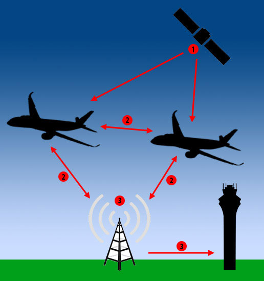
1. GPS satellites provide location information to ADS-B equipped aircraft. 2. ADS-B equipped aircraft transmit altitude, speed and velocity information to other ADS-B equipped aircraft and ADS-B ground stations. 3. ADS-B ground receive stations provide aircraft location back to other aircraft, as well as air traffic control centers. "ADS-B In" systems can be installed on any aircraft to display location information of other aircraft with ADS-B Out transmitters. Aircraft also transmit their location directly to other “ADS-B In” equipped aircraft within their transmit area. Thus, forming a long-range mesh network that shares real-time position information. For pilots flying with Visual Flight Rules cockpit-based ADS-B receiver displays provide earlier warning of aircraft in their flight area. This helps improve safety during inclement weather conditions.  

ADS-B Technology Solutions: Receiver Ground Stations

For operators of ADS-B ground stations, Southwest Antennas offers a high performance omni-directional antenna that operates at 1,090 MHz. This product was designed specifically for the ADS-B market; with a peak gain of 5.5 dBi which occurs 5 degrees above the horizon. This design offers long range performance for air-to-ground communication. It features an optimized horizontal pattern to help pull in signals from aircraft that are close to the ADS-B station or at high elevation angles. This antenna is designed for compatibility with any ADS-B receiver. As more aircraft fill existing routes, ADS-B helps air traffic controllers and pilots track active aircraft with more precision. These improvements not only increase safety but work to ensure the drone industry integrates smoothly and safely into national airspace.   Special thanks to Adam Krumbein of Southwest Antenna for allowing us to reprint this news item. Be sure to shop Southwest Antennas entire line to find affordable solutions for your next project!