Autopilots and advanced GNSS use types is an important piece to a UAVs functionality.
Obtaining the most accurate information about a UAV’s position and attitude — anywhere in the world and in all weather conditions — is fundamental.
Therefore, understanding the types and functions of advanced GNSS systems is essential.
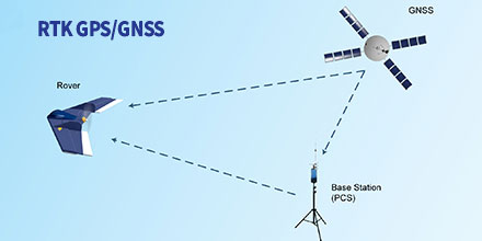
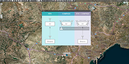
In Real-Time Kinematic (RTK) mode the UAV calculates its position in relation to the Base position location (GCS). In turn, the base station sends corrections to the GPS/GNSS air module.
This process improves the relative accuracy between both devices; eliminating errors introduced by the atmosphere and other factors.
With RTK positioning activated the relative accuracy improves to the centimetre scale.
Depending on operational needs, operators can activate RTK positioning for the flight duration. Or, operators can automate the function so the drone receives RTK corrections during critical flight phase.
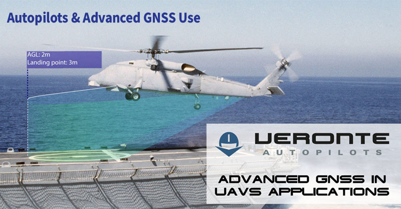
The landing phase is an example. RTK corrections ensure centimetre accuracy at touchpoint time (fixed-wings), landing on an exact point (multi-rotor) or activate in advanced modes (landing on a network or moving vehicle).
One drone application that takes advantage of RTK mode is photogrammetry.
Photogrammetry with drones makes possible to model a 3D surface, create plans and perform measurements. As such, achieving high accuracy is vital.
Drone camera positions with RTK calculate in real-time. This allows correcting camera positions of a few precision centimetres, both vertically and horizontally.
With this method, a moving vehicles attitude and orientation is estimated without the use of a magnetometer or other sensors sensitive to electromagnetic interference.
For this, a minimum of two GNSS antennas (GPS, Glonass & BeiDou) provide a known relative position between them.
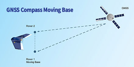
The reference station and mobile receivers can move while calculating a precise vector between the receiver antennas. They calculate the position and the attitude of the vehicle based on the GNSS signal.
Helicopters frequently use this model in order to achieve magnetometer redundancy.
An example of loss orientation is in the vicinity of high voltage towers. Since the electromagnetic interference presence interferes with the magnetometers measurement.
In this model, a fixed base station provides the corrections for the platform orientation.
Plus, the UAV’s avionics system can use previously measured coordinates of the antenna position at the base. This guarantees a better absolute drone position.
Knowing the two vectors between the base and each UAV antennas, the avionic system calculates the vector between the two air antennas.
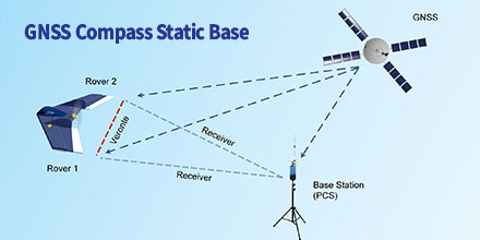
Uses include landing on mobile platforms such as ships.
As such, the accuracy of the mobile platform is much greater when communicating orientation corrections through the fixed base.
Veronte Autopilot incorporates all these types of GNSS use without the need to integrate any additional hardware.
A double GNSS sensor (GPS, Glonass & BeiDou) — on the ground and in the air — can activate from Veronte PIPE software. The activation is done in a simple way with the wizard created for the different scenarios.
At Embention, our team of Engineers continuously incorporate the latest technology into our autopilots.
Veronte Autopilot features a navigation system that — regardless of location and weather — provides high accuracy information about the position and attitude of the drone.
