Description
The VN-300 is a miniature, high-performance Dual Antenna GNSS-Aided Inertial Navigation System that combines MEMS inertial sensors, two high-sensitivity GNSS receivers, and advanced Kalman filtering algorithms to provide optimal estimates of position, velocity, and orientation.
By utilizing two separate GNSS receivers and antennas, the VN-300 enables accurate heading measurements without reliance on vehicle dynamics or magnetic sensors, providing unmatched performance under both static and dynamic conditions.
Key Benefits
- 0.3° GPS-Compass Heading
- 0.3° Dynamic Heading
- 0.1° Dynamic Pitch/Roll
- 5°/hr Gyro In-Run Bias (typ.)
- 800 Hz IMU, 400 Hz Navigation Data
- ±16 g Accelerometer Range
- ±2000˚/sec Gyroscope Range
- Thermal Calibration
- Made in the USA & ITAR-Free
Small Form Factor
SMD and Rugged Packages
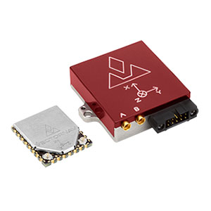
The VN-300 is available in two different packaging options: the surface mount device (SMD) and the “Rugged” module.
VN-300 SMD
The VN-300 is the first and only Dual GNSS Antenna Inertial Navigation System in a single surface mount package. At the size of a postage stamp, the VN-300 SMD requires only a single 3.2-5.5V power supply, and can be directly embedded into a user’s electronics. Interface with the VN-300 SMD is made easy by using either the serial 3V TTL (UART) or the Serial Peripheral Interface (SPI).
Size: 24 x 22 x 3 mm
Power: 185 mA @ 3.3 V
Mass: 5 g
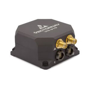
VN-300 Rugged
The VN-300 Rugged is the “plug and play” version of the VN-300 SMD. Enclosed in a clamshell precision anodized aluminum enclosure, the VN-300 Rugged offers additional protection of the internal MEMs sensors, GNSS receivers and electronics. The use of precision CNC milled aluminum parts ensures that the axis alignment provided by our factory calibration process is maintained during installation in its final configuration. Interfacing with the module is made through a locking 10-pin connector, as well as two MMCX connectors for external active GPS antennas.
Size: 45 x 44 x 11 mm
Power: 250 mA @ 5 V
Mass: 30 g

Dual GNSS-Compassing Algorithm
The VN-300 provides the ability to accurately estimate true heading (azimuth with respect to True North) in both static as well as dynamic conditions without any reliance on magnetic sensors.
This is accomplished by utilizing GPS interferometry techniques, which measure the heading of the vehicle or platform without any assumptions regarding the vehicle dynamics (RTK moving baseline technique).
This is a crucial feature for applications that require an accurate heading at startup, or in situations where insufficient motion is present to perform dynamic alignment.
Key features of VectorNav’s GNSS-Compass algorithms include:
- Magnetic independent
- Automatic transition between AHRS, INS and GNSS-Compass
- Adjustable GNSS antenna baseline lengths for shorter start-up times or increased heading accuracy
- Heading accuracy between 0.15° and 1.2° (RMS)
- Start-up in under 2 minutes
- Raw pseudorange, Doppler & carrier phase outputs
Inertial Sensor Calibration
MEMS inertial sensors are subject to several common sources of error: bias, scale factor, misalignments, temperature dependencies, and gyro g-sensitivity. To ensure the highest level of accuracy, all VectorNav sensors undergo a rigorous calibration process to minimize these error sources. Compensation parameters calculated during these calibrations are stored on each individual sensor and digitally applied to the real-time measurements.
The VN-300 undergoes this calibration process over the full thermal operating range of the sensor (-40°C to +85°C). Unlike the VN-100 and VN-200, the VN-300 is not available in a standard room temperature calibration.


GNSS/INS Kalman Filter
The VN-300 incorporates the latest advancements in aerospace-grade Extended Kalman Filter (EKF) inertial navigation algorithms specifically tailored to solve problems typically faced by industrial users.
The VN-300 utilizes the onboard EKF to optimally combine high bandwidth inertial sensor measurements with high-accuracy, low bandwidth GNSS measurements to provide high-accuracy, low latency position, velocity, and attitude measurements.
Key features of VectorNav’s INS algorithms include:
- Automatic filter initialization & dynamic alignment
- Real-time gyro & accel bias tracking & compensation
- GPS delay compensation
- Synchronized to GPS time
- Automatic transitioning between AHRS & INS modes
- Operates as a True Inertial Navigation System – no mounting restrictions or velocity alignment assumptions
10-Axis MEMS IMU
Utilizing the latest advancements in MEMS technology, the VN-300 incorporates an assortment of inertial sensors, including a 3-axis accelerometer, 3-axis gyroscope, 3-axis magnetometer, and a barometric pressure sensor.
The VN-300 has been designed to achieve the highest performance possible by filtering out common error sources, such as sensitivity to supply voltage variations and temperature dependent hysteresis.


High Sensitivity GNSS Receivers
The VN-300 incorporates two onboard high-sensitivity 72-channel, L1, GNSS receivers. Two U.FL (VN-300 SMD) or MMCX (VN-300 Rugged) connectors are provided for connection to external active GPS antennas.
Receiver Type: 72-channel L1 GNSS
Update Rate: 5 Hz
Sensitivity: -159 dBm Tracking
Time-to-First-Fix (Cold/Warm Start): 26 s
Time-to-First-Fix (Hot Start): < 1 s
Additional Options for VN-300
SMD Development Kit:
- Development board with pre-installed VN-300 SMD
- (2) micro USB to USB cables (2 & 3 m)
- (1) 1.8m (6ft) DB-9 Serial Cable
- (2) GPS Antennas
- (2) Coin Cell Batteries
- DIP stick
- CD with software development kit
- Product documentation
- Carrying case
Rugged Development Kit:
- VN-3oo Rugged Module
- (1) RS-232 Serial Adapter Cable
- (1) USB Adapter Cable
- (2) GPS Antennas
- Cable Connection Tool
- CD with software development kit
- Product documentation
- Carrying case
VN-300 Cabling & GPS Antenna
Custom Interfacing Cables and GPS Antenna: Custom cables of varying lengths and/or with certain pins broken out and certain variations of the GPS antenna are available upon request. Prices and lead times on such custom cables
and GPS antennas vary. Contact us to order.
Connectors: The VN-300 Rugged uses Harwin 10-pin locking connectors. The part numbers for these connectors are: Harwin M80-5001042: male connector on the VN-300 Rugged and Harwin M80-4861005: female connector used on VN-300 Rugged cables.
Product Variations Available:
- USB Cable Rugged
- RS-232 Cable Rugged
- Pigtail Cable Rugged
- VN-300 GPS Antenna (Tallysman 2412)
About VectorNav
VectorNav Technologies is a leading developer and manufacturer of high performance inertial navigation systems using the latest in MEMS sensor and GPS/GNSS technology. Since its founding in 2008, VectorNav has provided systems integrators in the Military, Aerospace, Marine, and Robotics industries with inertial navigation solutions with best-in-class price to performance ratios. VectorNav Technologies is headquartered in Dallas, Texas, USA and is an AS9100 certified company.