NEXUS 800 Powered by HYPACK
NEXUS 800 powered by HYPACK is a full end-to-end solution that represents a new paradigm in UAV data collection by seamlessly harmonizing LIDAR data with photogrammetry.
View cart
- Description
- Specifications
Description
NEXUS 800 powered by HYPACK is a full end-to-end solution that represents a new paradigm in UAV data collection by seamlessly harmonizing LIDAR data with photogrammetry.
The Nexus 800 is a turnkey system that tightly integrates hardware and software to provide a cutting-edge solution for LIDAR survey planning, data acquisition, post processing and analysis, and product creation.
Features:
- Complete GNSS aided inertial navigation system
- Single/Dual LIDAR return with a 360 degree field of view
- LIDAR and Photogrammetric data acquisition
- Real-Time Image and Point Cloud viewing
- Correlation of Point Cloud and georeferenced imagery via postprocessing
- On-board Windows® PC for rapid data processing and product creation
- Volume computation and data analysis
- Full flight and software training and support
The Nexus 800 multi-sensor design philosophy tightly integrates hardware and software delivering functionality required for critical projects demanding accuracy and efficiency.
Key Capabilities:
- LiDAR and Photogrammetry mapping UAS
- Data Collection, Processing, Real Time Data Visualization aboard aerial platforms
- Complete GNSS aided inertial navigation system
- Single/Dual LiDAR return with a 360-degree field of view
- Real-Time Image and Point Cloud viewing
- Correlation of Point Cloud and geo-referenced imagery via post processing
- On-board Windows® PC for rapid data acquisition
- Hypack software provides volume computation and data analysis provides the user with powerful tools to produce high quality datasets through a full featured point cloud processing modules that allow the user to edit, manipulate, and produce industry standard product outputs such as LAS or XYZ
- Highest wind resistance of any LiDAR UAS so you stay on schedule and fly when you need to fly
- Redundant safety features
- Full waypoint navigation
|
Software Planning, Acquisition, Synchronization & Processing: HYPACK-HYSWEEP® provides the tools necessary to design your survey, collect and process your LIDAR and photogrammetric data, calculate your volume quantities, generate contours, and export data to XYZ, DXF, LAS, etc |
|
|
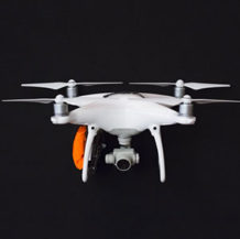
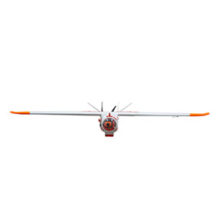
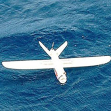
UAV Platform:
|
|
|
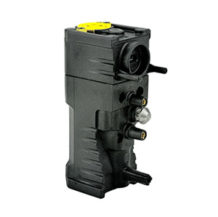
INS/GNSS Motion Compensation and Geo-referencing: Ellipse-D provides unmatched heading, attitude, and position accuracy in real-time and postprocessing. This is the ideal sensor for cost-effective survey.
|
|
|
LIDAR Point Cloud Acquisition: Velodyne’s new Puck LITETM sensor is the smallest, newest, and most advanced product in the Velodyne 3D LiDAR product range.
|