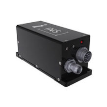
Ellipse2-D: Dual Antenna RTK INS
A compact INS with integrated dual-antenna, survey-grade RTK GNSS receiver.
View cart
- Description
Description
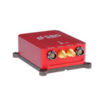
Ellipse2-D: Dual Antenna RTK INS is a compact Inertial Navigation System with integrated dual-antenna, survey-grade RTK GNSS receiver for accurate Heading and Position.
It provides Roll, Pitch, Heading, Heave, Velocity, and Position in real-time and post-processing.
New version: lower power, full constellations, raw data for post-processing in standard.
High Accuracy for Such a Small Sensor
- 0.1° Roll and Pitch over 360°
- 0.2° Heading (Dual Antenna RTK GNSS)
- 5 cm Real-time Heave, adjusted to the wave period
- 2 cm RTK GNSS Position (option)
- Post-processing with Qinertia PPK Software
- Full development kit available
Key Features
- Very Low Noise Gyroscopes – we have selected state-of-the-art MEMS sensors, especially very low noise gyroscopes
- Efficient Vibrations Handling – high quality accelerometers with internal FIR filters coupled with Coning & Sculling integrals to provide efficient vibration rejection
- Robust Position during GNSS Outages – for the INS models (E, N, D), the internal Extended Kalman Filter fuses in real-time inertial and GPS data for enhanced position and orientation measurements in harsh environments (urban canyons, tunnels, etc.)
Ellipse2 Series by SBG Systems

Applications
UAV
Inertial Navigation Sensors for UAV Navigation and Payload Stabilization & Orientation. An Inertial Navigation System (INS) provides Roll, Pitch and Heading information which are fused with GNSS data for real-time, robust navigation — even in challenging conditions, near building or power lines for example.
UAV-Based Survey
Real-time and post-processing LiDAR stabilization and Point Cloud Georeferencing. An INS delivers motion and position information. It is used to synchronize and stabilize camera and LiDAR precisely while mounted onto the UAV. It is also used for accurate data geo-referencing in real-time or at the office using the post-processing software.
Gimbal Camera
IMU for Camera Stabilization, AHRS for Camera Orientation. Low latency between physical motion and output is critical in this type of application, additionally is high bandwidth and precise synchronization.
The Ellipse sensors show a total latency of less than 3 ms between motion and output. Furthermore, these units are carefully designed with signal conditioning and FIR filtering to provide very low latency and high bandwidth while protecting the measurement from vibrations.
Finally, we also pay attention to the gyroscopes and accelerometers synchronization to achieve the best accuracy.
Development Kit
SBG Systems has designed a powerful and easy-to-use Development Kit. In just a few seconds, you start evaluating and configuring your inertial sensor and integrate it in your system.
Qinertia INS/GNSS Post-processing Software
Qinertia is the SBG Systems in-house post-processing software. This full-featured software enhances SBG inertial navigation systems performance by post processing inertial data with raw GNSS observables.
Learn more about Qinertia.
About SBG Systems
SBG Systems is a fast growing supplier of miniature, high performance and innovative motion sensing systems. They offer a complete line of inertial sensors based on state-of-the-art MEMS technology such as Attitude and Heading Reference System (AHRS), Inertial Measurement Unit (IMU), Inertial Navigation Systems with embedded GPS (INS/GPS).