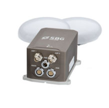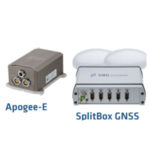
Apogee-E: Versatile Inertial Navigation System
A highly accurate Inertial Navigation System that connect to a SplitBox GNSS or any survey grade external GNSS receiver for optimal navigation.
View cart
- Description
- Specifications
Description
Apogee-E is a highly accurate Inertial Navigation System that connect to a SplitBox GNSS or any survey grade external GNSS receiver for optimal navigation.
The ITAR Free Apogee-E is the most accurate and versatile INS based on the robust and cost-effective MEMS technology.
High Accuracy:
- 0.008° Roll & Pitch (RTK)
- 0.025° GNSS-based heading (4m baseline)
- 1 cm Position (Depends on GNSS receiver)
- Post-processing with Qinertia INS/GNSS PPK Software
- 5 cm Real-time Heave
- 2 cm Delayed Heave
Apogee-E embeds:
- The latest MEMS gyroscopes and accelerometers
- A Web Interface for Easy Configuration
- A 48h Internal Data Logger for Post-processing
Apogee Models Available

Positioning with an External GNSS receiver
The Apogee-E connects to any survey grade GPS/GNSS receiver to provide navigation data. GNSS information is fused in real-time with inertial data to provide the best performance. It features a unique GNSS error model to take into account every receiver specific behaviors.
Positioning with a SplitBox GNSS
The SplitBox GNSS integrates the latest generation tri-frequency GNSS receiver that supports RTK and Precise Point Positioning (Marinestar, TerraStar, Veripos, OmniSTAR, etc.). It also provides raw data for Post-Processing. The SplitBox GNSS embeds a Dual Antenna receiver for highly accurate and robust heading in every dynamic conditions.
Extensive Heave Calculation
The Apogee provides a real-time heave accurate to 5 cm. For more simplicity, the user doesn’t have to enter the wave frequency; the Apogee automatically detects it and constantly adjusts to it.
Apogee comes also with a unique delayed heave feature with no additional software nor user action. This specific algorithm allows a more extensive calculation, resulting in a heave accurate to 2 cm displayed in real-time with a little delay.
Applications
Marine
Apogee-E combined with the SplitBox GNSS is the perfect solution for hydrographic applications, from shallow to deep water. Easy to install, Apogee is already compatible with Hypack and QINsy software. Use the Delayed Heave feature to survey in the worst sea conditions. Combined with an available PPP services (Marinstar, TerraStar, Veripos), it provides a 10 cm position accuracy.
Land
The Apogee-E can be connected to your own GPS/GNSS receiver and access RTK and Precise Point Positioning (PPP) services through your receiver or through the SplitBox GNSS (TerrasStar, OmniSTAR). It delivers reliable position thanks to its tight integration of Inertial Sensors, GNSS and Odometer data.
Aerospace
Apogee-E has been designed to be integrated in a new or already existing aerial mapping system. It can either use your own GNSS receiver, or the one embedded in the SplitBox GNSS, to deliver unmatched position and orientation accuracy. Thanks to its very low noise gyroscopes, it provides extremely accurate data for advanced LiDAR data georeferencing.
Complementary Equipment and Software
Connection, Synchronization and Software
The SplitBox provides a simplified interface for easy connection and synchronization with external equipment such as odometer, differential corrections, computers, or survey instruments. The SplitBox with integrated GNSS receiver additionally delivers navigation data with a large choice of positioning services (Marinestar, TerraStar, etc.).
Qinertia INS/GNSS Post-processing Software
Qinertia is the SBG Systems in-house post-processing software. This full-featured software enhances SBG inertial navigation systems performance by post processing inertial data with raw GNSS observables.
Learn more about Qinertia.
About SBG Systems
SBG Systems is a fast growing supplier of miniature, high performance and innovative motion sensing systems. They offer a complete line of inertial sensors based on state-of-the-art MEMS technology such as Attitude and Heading Reference System (AHRS), Inertial Measurement Unit (IMU), Inertial Navigation Systems with embedded GPS (INS/GPS).
Physical Characteristic
| Weight | < 690 grams / 1.52 pounds |
| Dimensions (L x W x H) | 130x100x58mm / 5.12×3.94×2.28 |
| Consumption | < 3 W |
| Supply | 9 to 36 VDC |
Interface
| Aiding Sensors (input) | 2x GNSS; RTCM; Odometer; DVL; Depth; USBL*** |
| Protocols | Output: NMEA; ASCII; Binary; TSS; Simrad |
| Input: NMEA; Trimble; Novatel; Septentrio | |
| Hemisphere; Veripos; Fugro; PD0; PD6 | |
| Output rate | 0.1 to 200 Hz |
| Logging Capacity | 8 GB or 48 h @ 200 Hz |
| Serial RS-232/422 | Model N/D – 2 outputs / 4 inputs |
| Model A/E – 3 outputs / 5 inputs | |
| Ethernet | Full Duplex (10/100 base-T) |
| CAN | 1 CAN 2.0 A/B bus up to 1 Mbit/s |
| Pulses | Inputs: PPS; Event marker up to 1 kHz |
| Outputs: SyncOut; Trigger; PPS | |
| 5 inputs / 2 outputs |
Sensor Performance
| Accelerometers | Accelerometers | Gyroscopes | |
| Measurement range | 2g | 10g | 100°/s |
| Bias in-run instability | <2µg | <15µg | <0.08°/hr |
| Random Walk | <15µg/√Hz | <75µg | < 0.012°/√hr |
Environmental
| IP rating | IP68 |
| Specified temperature | -20 to 60 °C / -4 to 140 °F |
| Operating temperature | -40 to 71 °C / -40 to 160 °F |
| MTBF (computed) | 50000 hours |
| Operating vibrations | 20 Hz to 2 kHz as per MIL-STD-810G |
| Accelerometer 2 g: 1 g RMS | |
| Accelerometer 10 g: 8 g RMS |
Full specifications can be found in the Apogee Series leaflet here.