Airborne Hyperspectral Imaging Systems
Resonon’s Airborne Hyperspectral Imaging Systems contain all hardware and software necessary to acquire and analyze georegistered hyperspectral data.
View cart
- Description
Description

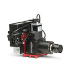
Airborne Remote Sensing System
Resonon’s airborne systems are completely integrated turnkey solutions. They include all the hardware and software necessary to acquire georegistered hyperspectral data.
Systems can fit most of Resonon’s hyperspectral imaging cameras, covering the 400 – 1700 nm spectral range.
Airborne systems can mount on both manned and unmanned aerial platforms. Payload weights begin at 1.6 kg.
System Components
- Data Acquisition Unit
- Post Processing & Analytical Software
- System Control Unit – for onboard data collection and storage
- GPS/IMU – to record sensor position and orientation
- Georectification Software – to correct for GPS/IMU information
- Radiometric Calibration
- System Mount for UAV’s or Piloted Aircraft
- Calibration Target
- Protective Travel Case
- Downwelling Irradiance Sensor (Optional)
- Emlid RTK Base Station and Compatible
Radio (for centimetric positioning and
increased orientation accuracy) (Optional) - Training Services (Optional)

Complete System Weights

Power Requirements
12 – 24 V; 13 – 16W operating, 23W peak
Calibration Options

GPS/IMU Options

About Resonon
Founded in 2002, Resonon is located in Bozeman, Montana in the heart of the Rocky Mountains. We provide the industry’s most affordable turnkey hyperspectral imaging systems, as well as custom solutions for complex hyperspectral and optical applications. Our hyperspectral imaging cameras are lightweight, easy to use, have low stray light, low distortions, high SNR, and excellent image quality.